P
lease understand this is just the day-by-day itinerary. Please refer to the parent article for a more general description, map, links to other useful guides etc. You’ll find that parent article here: The Best Self Drive Plan for Iceland.

Two weeks in the summer in Iceland in a 4WD car is the absolute best way to see all that this beautiful country has to offer.
This trip will show you everything that is most interesting and leave you with very, very few places that you’d have to come back to later. You will also find easy ways to extend or cut short the plan by a day or two. Happy driving!
It’s a good idea to keep this plan with you when you’re on the road. So you might want to download it as a PDF file here: 15-day self drive itinerary – Iceland in a 4×4 vehicle (746 kB, PDF).
Arrival at Keflavik airport. Transfer by coach to Reykjavik. Walk around the city, have dinner on the waterfront or in the center. If you have time – visit one or two attractions from the next day’s plan. Alternatively: a visit to one of the city’s hot pools. Stay overnight in an apartment or hostel. Pick up your rental in the morning.
If you arrive in Iceland in the morning / before noon, you best start right from day 1 – that is: skip “day zero”. In this case, it would be a good idea to pick up your car right away at the airport – usually there is an additional charge, but the bus ride to Reykjavik is also approx. 50 EUR per person. Besides, picking up your car at the airport usually takes much less time than at ‘depots’ in the city itself.
If you arrive in Iceland in the evening or afternoon, however, it’s probably best to take a bus (comfortable coaches) to Reykjavik that day, stay for the night in the city, and set off around the following morning. And don’t worry that you won’t see all the interesting places in Reykjavik. You will have a chance to see it again and honestly – the attractions of the capital pale in comparison with what the rest of the island has to offer. You definitely don’t want to spend too much time here.
If you do have a good half-day to see the city, the places that you want to visit are those that will inform your further sightseeing. That will help you understand Iceland in all it’s aspects. Hence these are what we’d prioritise:
car pick-up – Thingvellir – Kerid – Seljalandsfoss and Gljufrabui – Thorsmork
200 km / 125 mi, 4h drive, 4h sightseeing
Driving in Iceland, unfortunately, you have to start by picking up the car and shopping. Unfortunately, because all tourists starting their trip that day want to pick up the car as early in the morning as possible, and practically in every rental company this creates quite a traffic jam.
It is worth contacting your rental company the day before and try to arrange, for example, to pick up the car the previous evening. If it is ready, the rental company may agree to it, because this morning traffic jam is also a problem for them.
If that doesn’t work – well, you have to decide whether to show up at their place 15 minutes before opening and try to be the first in line, or let go of 2-3 hours of the worst crowd and arrive around 10 or even 12.
Picking up an ordinary car can be pretty quick, while picking up an RV is always at least half an hour – after all, you have to familiarize yourself with the car (operation of the stove, heating, 4×4 drive and locking differentials – all very important things).
After picking up the car, we head to the supermarket to get groceries for the first few days. We write more extensively about this in the article Grocery Shopping in Iceland: Prices and Store Opening Hours. You’ll probably spend about 2 hours on this, too (don’t get overly optimistic).
All in all, it’s difficult to realistically hit the road before noon on that first day, but of course on the scale of a 2-week trip it doesn’t make that much difference.
The first point on the route will be Thingvellir National Park (Þingvellir). This is a very important place for the history of settlement in Iceland. This is where the first local parliament convened and this is also where condemned witches were drowned… The entire park is also a beautiful presentation of the continental rift, emerging here from the ocean floor to the earth’s surface. To a certain approximation, we can say that we walk here between two tectonic continental plates: the North American and the European. There are few places in the world where you can take such a walk….
You can read more about Thingvellir park itself and all its attractions in the article Thingvellir – the Mid-Atlantic Ridge on the Surface.
On the other hand, if you want to better understand the phenomenon of the spreading of continental plates and the geological history of Iceland, take a look at our series of geological guides, starting with this article: How Has Iceland Formed – Its Geology in a Nutshell.
If you have some time, you can go down and east of the main park to the Silfra rift, where dives are organized for those willing to dive into the flooded part of one of the rift crevasses. You can read more about this attraction in this article: Silfra – Diving in the mid-Atlantic Ridge.
From Thingvellir you drive southeast, but if you’d like to relax in the hot springs or see how traditional Icelandic rye bread is baked in the volcanic sands, drive straight east to Laugarvatn Fontana first (full description of the place: Laugarvatn Fontana – Hot Pools, Baths and a Bakery – a 3 in 1).
The pools are open from morning to night, but the presentation of traditional baking only takes place at 11:30am and 2:30pm – make sure you make it in time.
How much time you spend there is entirely up to you. The demonstration of baking traditional bread alone is about 1 hour.
This is perhaps the most famous volcanic crater, as it has a nice, distinct cone, a beautiful lake inside the crater, and the whole thing is close to Reykjavik and easy to get to. You can find a broader description of Kerid (Kerið) here: Kerid – Volcanic Crater Lake.
There will be a few more craters like this on our route, but it’s a shame to miss it if you’re already driving this way, especially if it’s sunny and the colors of the crater show up in all their glory.
These are two beautiful waterfalls and very popular, as they lie just off Highway 1. In summer, there is a paid parking lot and a small store and restrooms at the first one (the one where you can walk behind the water column). At the second one – the one hidden in a rock crevice – you can park for free. The walk between the waterfalls is about 15 minutes (500 m) one way. Read more about them here: Seljalandsfoss and Gljufrabui – Two Beautiful Waterfalls.
We have devoted several separate articles to visiting Thorsmork. It’s a beautiful area, but one that requires a more extensive description. You can find all the relevant information and links to more in-depth or detailed articles here: Thorsmork – the Legendary Thor’s Wilderness.
Remember that driving into Thorsmork, requires crossing several glacial streams. In a good off-road vehicle and with a little caution and luck, getting to Basar Hut should not be a problem. Be sure to read the previously indicated article about Thorsmork before you decide to drive here.
Stakkolstgja is a massive canyon in the Thorsmork region, on the way to Basar Hut. It’s worth stopping by and going inside, although it will probably take about an hour to get to the tighter, back part of it. Read more and see photos here: Stakkholtsgja – a Picturesque Canyon in Thorsmork.
Even if you skipped Laugarvatn Fontana today, you will probably reach Basar Hut around 9 p.m. Therefore, nothing more is planned for this day.
However, if you managed to save some time on the way, take a short evening hike to the small peak towering above the campground – the Basar Circle route to Bolhofud Hill. You can read more about sleeping and trekking around Basar Hut in this article: Basar Hut – Camping and Shelter in Thorsmork.
Thorsmork is a magical place, but also risky (road F249 is most likely excluded from your car insurance). If you decide not to drive there or the weather does not permit it, head straight to Skogar campground.
You will then have a chance to enjoy the sunset over beautiful Skogafoss, some time to trek along the beginning of the famous Fimmvörðuháls trail and time to walk to Kvernufoss. You can also leave your car for 2-3 days in Skogar and enter Thorsmork via Fimmvörðuháls for a few days of trekking. Unfortunately, returning to Skogar from Thorsmork by bus is a bit difficult. You can get out to Bru Base, near Seljalandsfoss, but you’d have to hitchhike the rest of the way. You can read more about it in the articles about Thorsmork.
Additionally, on your way to Skogar you can have a look at one of the oldest hot pools in Iceland, the extremely photogenic, although not very hot, Seljavallalaug.
Hiking tours from Basar Hut.
The area around Basar Hut offers many very interesting hiking routes. Although I suggest spending only 1 day here (because there is a whole Iceland waiting to be explored), you can spend much more time in the area. You can read all about the trails and attractions around Basar Hut in the article: Basar Hut – Camping and Shelter in Thorsmork.
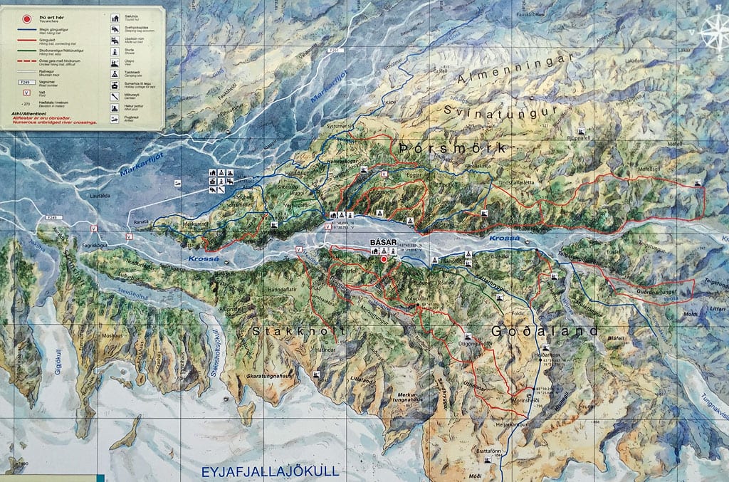
Tourist map of Basar Hut area
There’s a couple of options to fill your hiking day:
Depending on weather, trails condition and your appetite for hiking your can combine any of the above ideas freely.
All of these trails are beautiful, picturesque, spectacular and amazing. Which ever you choose, you won’t be disappointed. But if we must put them in some order, to make it easier to decide: in our opinion the long southern trail is the most demanding, but also the most spectacular one. While the short northern trails being perhaps the easiest, but also slightly less rewarding (albeit Valahnukur – if open – is absolutely top class).
Speak to the warden, check the forecast, consider if you’d rather take one longer hike or two shorter ones and be sure that whatever you decide, you’re in for a full day of landscape greatness.
You spend one more night in Basar Hut. Unfortunately the huts and hostels on the north bank of Krossa are easy to reach by foot, but difficult and dangerous to get to by car. Please don’t attempt that.
Skogafoss – Reynisfjara – Fjadrargljufur – Skaftafell (Svartifoss).
230 km / 145 mi, 4h drive, 6h tour
Skogafoss is a beautiful and powerful waterfall. It’s neither the biggest nor the strongest, but it’s certainly very photogenic, especially since it can be viewed both from below – going practically right up to the cascade itself – and from above.
The waterfall itself certainly looks most interesting from below, but the panorama of the area from the viewing platform above the cascade is also worth seeing.
If you have more time, the area offers several interesting and beautiful hiking trails including a short, but very rewarding hike to a beautiful waterfall Kvernufoss. Read more about this area here: Skogafoss – a Spectacular Waterfall on the South Coast.
The pool is located in a beautiful place and in pictures it can look very interesting, but in reality it is simply neglected. The water is warm at best (about 20 ºC / 70 ºF), and you have to spend at least an hour just to get there back. Read more about it here: Seljavallalaug – One of the Oldest Swimming Pools in Iceland.
Reynisfjara is one of the black beaches, quite common on the south coast of Iceland. This one is special, however, because it is decorated with beautiful basalt pillars, there is a small but interesting cave right next to it, and the beach offers beautiful views of rock needles protruding from the sea. It is definitely worth coming here, although the place is usually swarming with tourists. Be sure to watch out for the ocean waves, too. You can read more in this article: Reynisfjara – a Beautiful but Dangerous Black Beach.
Optional extras:
Fjadrargljufur Canyon is an absolutely beautiful place. Not very large, but surrounded by beautiful greenery it is deservedly popular. Unfortunately, much of this popularity – and its alternative name – is due to Justin Bieber, who shot some of the footage for one of his music videos here and drew crowds of tourists to the canyon. You can read more about this beautiful and popular place here: Fjadrargljufur – Justin Bieber’s Canyon.
Optional extras:
If you have one day free (or at least half a day) and are willing and able to take it out of your entire itinerary, then instead of returning from Fjadrargljufur on Route 1, consider going further north. Alternatively, consider staying overnight in nearby Kirkjubæjarklaustur and hiking to Laki the following day.
The road to Laki volcano is strewn with fords and heavy rocky sections, so it’s very slow going (especially if you carefully inspect each ford before you drive into it), but there’s no denying its beauty. Unfortunately/unfortunately, it’s a closed loop and once you reach the northern end and go around the small loop there, you’ll have to take the same road back.
The scenery along the F206 road is beautiful, and the Laki volcano itself is famous for its huge 1784 eruption, so it’s worth the trip. A short hiking trail at the end of the road leads right through the middle of one of the craters. However, on the other hand, you will see quite similar landscapes still around Askja and Landmannalaugar, so you can also survive without seeing this corner. In the end, I put this place on the list of options rather than on the main route probably mainly because I terribly dislike “retracing my steps” – going back and forth along the same road 🙂
Along the way you can also see the quite nice Fagrifoss waterfall.
Skaftafell is a very nice and interesting area. The biggest attraction is the Svartifoss waterfall. Equally interesting are two glaciers lying in the immediate vicinity and several hiking trails leading through the surrounding hills.
The main waterfall and the smaller ones on the way to it are actually a ‘must see’. Also, the glaciers are really worth approaching, because although walking on the glacier is of course very dangerous, you can approach them in safety here. And just listening for a moment to how such a living glacier crackles and creaks is absolutely unforgettable.
You can find hiking routes, maps and more detailed information here: Svartifoss – a Beautiful Waterfall in Skaftafell.
Optional extras:
Today we suggest an overnight stay at Skaftafell Camping. It’s a popular and even somewhat besieged campsite, but it offers good facilities and gives you the opportunity to go up to the mountains for sunrise or sunset… Just make sure the grounds are not soaking wet, when you arrive.
If the excess of tourists and general noise exceeds your endurance, you have seen the waterfall, and you do not intent to go for a sunrise over Skogafoss (in summer sunrise is as early as 3 AM), then not far away southeast you’ll find Svinafell Campground. It also offers good facilities, and it’s sure to be quieter and more peaceful.
360 km / 225 mi, 5:30h driving, 4h sightseeing
Today is a longer drive – we need to go around a large part of the Vatnajokull Glacier, so that on the next day we will have enough time to drive through the wild and absolutely beautiful area to Askja. We will see beautiful glaciers, waterfalls and an unusual “diamond” beach. We will also already enter East Iceland – a region much less popular with tourists, as it is already 100% out of reach of 1-day tours from Reykjavik.
Also, the road itself winding through the slopes of the fjords is quite an attraction; and if you decide to take the 939 shortcut you will also see a rather rare “Caution road with 17% slope” sign. 😮 Well, and you will have the opportunity to drive on just such a narrow, winding and really steep road… A great experience 🙂
Optional: glacier and Fjallsarlon bay, cruise on Jokulsarlon bay (and/or Fjallsarlon), Hofn town, Hvalnes lighthouse, Djúpavogskörin hot spring, Egilsstadir town, Vok pools (Vök Baths).
Jokulsarlon is an absolutely unique place and definitely one of the must-see “sightseeing points” of Iceland. The bay, where icebergs from the calving glacier float is a truly remarkable sight. On my first visit here – in 2005 – the glacier was much, much closer to shore. But even now the icebergs flowing slowly into the ocean are very impressive. To see the bay and the icebergs, you can drive up to where the bay cruises depart from, or stop earlier, at one of the scenic parking lots. If you don’t plan to take a cruise, the views from around the parking lot are in no way inferior to those from the tourist center.
If you have more time you can take a cruise on the bay, between the icebergs – the mountains seen up close are very impressive, but still, such a cruise is at least +2h to the tour time. More about the bay can be found here: Jokulsarlon Lagoon and the Diamond Beach.
Diamond beach (Breiðamerkursandur) is a sort of a “by-product” of the Jokulsarlon glacier. Fragments of the glacier that have reached the ocean are drifted here by the current and thrown ashore on the beach. They form beautiful, though impermanent “ice sculptures.” Definitely worth seeing. Read more in the Jokulsarlon article above.
Stokksnes is a peninsula from which, with the right light (time of day and year), the nearby mountain – Vestrahorn – looks beautiful. Photographers lucky enough to have light (or the patience to wait for it) can “hunt” the most beautiful shots of the whole trip here…. There is also a cafe and a small Viking village built for a film set. Stokksnes – a Beautiful Cape Near Hofn.
If the weather is nice you have a chance for some of the most beautiful Iceland photos here. The descent from the main road is only about 5 km (one way) or less than 10 minutes. Be warned, however, that if the weather is nice, you can spend an infinite amount of time at the site, especially if you have a photographer in tow 😉
Hengifoss and neighboring Litlanesfoss are some of the prettiest waterfalls in Iceland. They cut through beautiful layers of colorful rock and flow among magnificent basalt columns. They require about a 2-hour hike (round trip), but are definitely worth it. You can read more about them here: Hengifoss and Litlanesfoss – a Beautiful Pair of Waterfalls.
Optional extras:
Today’s day ends at the gate of the interior. Less than 30 km away, the asphalt ends and the 910 road turns into its mountain version: F910.
Laugarfell is a very nice, albeit small mountain chalet, or rather: guesthouse. Located in a beautiful setting, providing access to sanitary facilities, a restaurant and a charming semi-wild hot spring.
If you have the time and desire – you can take a walk to the surrounding small waterfalls. The hostel staff will show you the way.
You can read more about this place here: Laugarfell Mountain Hotel – Eastern Gate to Iceland’s Interior.
Today before you is a long, but perhaps the most wonderful day of the entire trip. Strewn with extraordinary places, beautiful views and one-of-a-kind experiences. Suffice to say: you’ll have a chance to bathe in a warm lake inside a volcano crater… 😮
But also the road itself will be unusual, diverse and, in popular opinion, the most beautiful in the entire interior, even though not all of it is on Google Maps 🙂 There are quite a few kilometers to drive, and you will drive slowly on the F910 and F905 roads (even slower on the F88, if you choose to take it). So don’t underestimate the distance and don’t set yourself up for a fast “flight”. Pick any additional attractions carefully, be selective about it.
Hafrahvammagljúfur is a beautiful and powerful canyon. It can be seen from the dam at the lake, but having driven a little further north, we can approach its edge directly, or even descend and view it from below. Unfortunately a trip to the canyon floor would take at least 3 extra hours, so you have to settle for views from above.
You can reach the parking area at the beginning of the scenic path by a 4×4 vehicle by continuing north on the F910 road and turning right, east, at the first intersection.
If you do not have a 4×4 vehicle, you can also get there on foot along the path directly from the parking lot at the dam.
You can read more about the canyon and trips to it, and how exactly to get to the parking lot at the beginning of the path, etc., in this article: Hafrahvammagljúfur – a Massive and Beautiful Canyon in the East of Iceland.
East of Askja, the saying that the road is the destination becomes a reality. We rarely recommend the road itself, but it’s a necessity here. The F910 in this eastern section is simply beautiful. It leads through a great variety of landscapes – pumice deserts, lava fields, glacial streams (2 usually shallow fords and a big river crossed by a bridge); the road leads through fairly freshly solidified lava, but also through one already somewhat overgrown with moss. F910 east of Askja is definitely the most beautiful mountain road in Iceland. Perhaps it is second only to its western part, but that one is really difficult, inaccessible and demanding.
Askja crater is one of the iconic places in Iceland. A broader and in-depth description can be found in this article: Askja – a Volcano With a Swimming Pool. Very popular among Icelanders and – given its inaccessibility – also among tourists. Askja itself is beautiful and huge, but its treasure, or “cherry on the cake”, is the neighboring, much smaller crater – Viti. If there is no snow in the area and the descent to the interior of Viti is not closed, this is probably the only place in the world where you can bathe directly in the volcano crater … The water in the crater lake is not too warm (20-25 ºC / 70-75 ºF), but a bath in such a place is absolutely mind-blowing.
The walk from the parking lot at the nearby Vikraborgir lava field to Viti (about 2.5 km) is also very interesting in itself. Apart from the initial slight ascent, basically the whole way runs flat and takes no more than 45 minutes, and yet it’s a walk through a lava field – it feels a bit like walking on the moon….
Optional extras:
Dettifoss is Iceland’s most powerful waterfall and is impressive enough. Really powerful and very loud. It is definitely worth seeing, even if you have already seen many other waterfalls. More about the waterfall itself and whether it is better to view it from the east or the west (in my opinion, from the west) in this article: Dettifoss – Iceland’s Mightiest Waterfall.
Optional extras:
Asbyrgi is a huge horseshoe-shaped canyon. Everything about its construction, the legend of its creation, trekking and accommodation options can be found in a separate article dedicated to this place: Asbyrgi – a Scenic Horseshoe-Shaped Canyon.
Note that there is a very nice campground on site, and the trails in the canyon allow for short and longer hikes. A basic walk to the pond by the canyon wall is only 30′, but longer trails can keep you hiking a whole day. Definitely worth visiting.
We end the day at a beautiful campsite at the gates of a beautiful canyon. If you have a bit more time, you can spend the next day hiking the local trails. Park guards will certainly help you choose the most interesting option, but also in the aforementioned article about Asbyrgi you have a full list of these trails 🙂 If you don’t have all day, go to the Botnstjorn lake and the characteristic “iron” in the middle – Eyjan. You can also spend a few hours trekking tomorrow morning, so don’t push yourself too hard in the evening.
Alternatively, if Asbyrgi is very busy and you would prefer a quieter and more peaceful place, there is a campsite about 40 km (0:30 h) to the northeast – Camping 66.12 North. Beautiful ocean view, large grassy field, extremely nice owner and modest but well maintained facilities. And much closer to Husavik, and completely on the way. Highly recommended.
This day absolutely revolves around whales. It is best to call Husavik the day before to find out about the situation with whale watching cruises. Sometimes it is known that, for example, a storm is coming or has barely passed, and therefore morning or afternoon cruises are canceled or the organizers recommend a cruise 1-2 days earlier or later. These tips are worth considering.
If the cruises are completely canceled or the organizers advise a cruise in a day or two for other reasons, go to Myvatn first (here: Day 7), and you will easily go to Husavik in 2 days. It’s really worth figuring this out ahead of time.
If you are not drawn to the hot Geo Sea pools in Husavik, you can start the day with one of the longer hikes in Asbyrgi. In the following article you will find all the tips, descriptions of trails and suggestions for trips: Asbyrgi – a Scenic Horseshoe-Shaped Canyon.
Alternatively, you can also drive down to Dettifoss on a side you haven’t seen yet.
Or – e.g. if the weather is not conducive to walking at all – go to Husavik in the morning for a cruise (and possibly a spa), and in the afternoon reach Myvatn and start exploring that area.
Whale watching cruises are a wonderful thing if you actually manage to find and meet a whale. Therefore, we recommend cruises on RIBs / zodiacs. They sail further out into the bay and can go much faster, and therefore closer, to any mammal that can be spotted. We write extensively about the specifics and conditions of the cruises in this complete guide: Whale Watching in Iceland – All You Need to Know.
Optional extras:
This campsite offers fine amenities, but the cooking and dining area strongly underinvested. Still, it’s beautifully located and enjoys very low competition, so it’s OK to stay here for 1 night.
If you arrived at Myvatn relatively early, you can immediately see some of the attractions near the campsite – according to the plan for the next day (e.g. Eldhraun or Storagja) or go further and see the Leirhnjukur and Namafjall Hverir. You can also go shopping in the evening or go to Myvatn hot pools. Everything at your discretion 🙂
Every day in Iceland is filled with different attractions, but this one will be special. Just look at how long the list of main and additional attractions for today is (can you read all them names?)…
We start with a lot of very interesting and diverse volcanic and geological attractions around Lake Myvatn, and end with a drive along the famous Sprengisandsleid or F26, back to the south of the island. Amazing, epic, breath-taking.
350 km / 220 mi, 7:30 h driving, 4 h sightseeing
Leirhnjukur is one of the most beautiful lava fields and geothermal areas in Iceland. Colorful rhyolite rocks and volcanic lakes lie between fresh lava sheets. The directions of lava flow and successive stages of overgrowing with moss and lichens, as well as various forms of lava are clearly visible. Read more about it in an article about the local volcano system here: Krafla – a Huge Volcano Near Myvatn.
The whole area is quite large, but within 1 hour you can easily walk around it, at least on the main path. In key places, the path runs on wooden platforms – they protect tourists from twisting their ankles, and delicate mosses and lichens from being trampled. A similar place, although without such extensive lava fields, is the nearby Námafjall Hverir located right at the exit of road 863 to road 1, which is the next stop on today’s route.
Hverir in Icelandic literally means “hot springs”. Therefore, this word can be found quite often when traveling around Iceland and it means not only hot springs where you can bathe, but also ones like this here – completely unsuitable for bathing. Due to the nearby mountain – Namafjall (or Namaskard) – the full name of the place is Namafjall Hverir or Namaskard Hverir. However, signs indicating the turn to the car park on road no. 1 and the popular Google Maps describe the place simply as Hverir, so these full, exact names lose some meaning.
The area itself is full of very picturesque volcanic lakes and ‘chimneys’ (exhalations – sulfatars). There is a convenient viewing platform next to the car park, but it is definitely worth a walk between the bubbling mud lakes and hissing, smoking sulfatars – the experience is truly extraordinary. Shoes and pants dirty up to half calf with brick mud, unfortunately practically guaranteed 🙂 More on this: Námafjall Hverir – a Geothermal Science Fiction Landscape.
As of 2023 the parking lot is a paid one – 650 ISK per car.
Optional extras:
Hverfjall is a beautiful black volcano. It has an unusual structure, because its creation was quite unusual (see: Hverfjall – a Volcano Like no Other).
With the right lighting, it looks almost magical, and there are also beautiful views of Lake Myvatn from the top. That’s why you absolutely have to come here and climb the crater rim. Walk to the volcano from the car park takes no more than 20 minutes, and the walk around the crater takes about 1 hour.
A separate article devoted to the structure and formation of various types of volcanoes can be found in this guide: How Iceland’s Volcanoes Work.
Optional extras:
The Dimmuborgir lava field is literally next door to the Hverfjall volcano. After the main road (848) we will drive a little bit (about 1 km) and we will go east again. Dimmuborgir is a beautiful lava field shaped both by the magma outflows themselves and by the direct presence of the lake and groundwater. We described its creation and curiosities separately in the article Dimmuborgir – the ‘Black Fortress’ Lava Field.
It is a very popular place and the destination of many coach trips. Both the parking lot and the cafe, as well as the lava field paths themselves can be really crowded.
Nevertheless, you just have to see at least a few rock windows, caves, chimneys and other various forms created here. The most interesting walk is probably a combination of the yellow route and the red and blue route. All in all it’s about a 2km walk and even with frequent stops it shouldn’t take more than 1 hour.
The Skutustadagigar pseudo crater field (Skutustadagigar – Unique Pseudo-Craters) is located on the southern shore of Lake Myvatn. This place is absolutely unique not only on an Icelandic, but probably on a global scale. On a small peninsula, we have a cluster of several smaller and larger pseudo craters, which were formed thanks to the explosion of steam, not lava …
You definitely need to take a shorter route past Stakhólstjörn cove – it’s a walk of about 1 km and at least 10 craters along the way. It will take you no more than half an hour. The longer route – around Stakhólstjörn – is about 2 km and a few craters more. If you have time – it’s definitely worth it, but it’s not necessary and you can absolutely skip that.
Godafoss is one of the larger and prettier waterfalls in North Iceland (although of course it can’t compare to the mighty Dettifoss). It owes its name – the Waterfall of the Gods – to a legend from the time when Iceland was adopting Christianity. You can read this story in the article about the waterfall: Godafoss – Gods’ Waterfall.
The parking lot exit from road 1 is right next to the gas station on the east side of the Skjálfandafljót river. After a comfortable and short walk (approx. 500 m) you can reach the very foot of the waterfall.
The further route – to the F26 road – requires driving to the west bank of the river. Therefore, along the way, it is certainly worth going to the western parking lot and the viewpoint and seeing the waterfall from there. From the vantage point, you can practically see it en face – completely straight ahead and this is probably its most beautiful side. However, it is impossible to go down here, so we only see the waterfall from above here.
You can absolutely skip the smaller Geitafoss waterfall lying nearby – a bit closer to the bridge on the river. You can see it from road 1 and I think that everyone will agree that on an Icelandic scale it is nothing particularly interesting.
We return to the interior and at its gate we are greeted by perhaps the most beautiful waterfall in Iceland – Aldeyjarfoss (Aldeyjarfoss – One of Iceland’s Most Beautiful Waterfalls). It looks beautiful in the pictures, but in reality it is also no worse.
Parking is right next to the waterfall viewpoint. How much time you spend here is of course entirely up to you 🙂
If you’re not driving a 4×4 car, you should leave your car just before the last driveway and cover the end of the route on foot.
Nyidalur is a good stop half way through the wilds of Iceland. There is a small mountain shelter and a kind of campsite. The immediate area can be seen quite well directly from the windows of the car, but if you can afford it, you can go hiking on one of several routes from here or drive up to the beautiful, though slightly hidden Vornaskard lava field. Just confirm with the guard that the road is passable and open.
You can read more about the whole place in the article dedicated to it – Nyidalur – a Valley in the Icelandic Highlands.
Landmannalaugar is absolutely one of the top sightseeing spots in Iceland. Half a day is enough to cover the most important and beautiful routes, but if you can stay here for two nights, you will be able to get around all the routes and you will not regret it.
We devoted a whole, large, separate article to this beautiful place: Landmannalaugar – Fairytale Rainbow Mountains. Go through it to find out everything important about both the campsite and the hiking trails in the area.
Optional extras:
Getting to the campsite requires (at the very end) crossing two fords. Sometimes these are fairly deep, but most often even the smaller cars can cope with them (although a 4×4 drive is of course absolutely necessary).
The campsite has a fairly large shop, a hostel restaurant (in a surplus bus), quite good showers and toilets, and the icing on the cake is a natural hot spring available to everyone.
You can also stay in the hut, but know that it is one of the most expensive ones in this type (11,000 ISK per night, per person, own sleeping bag) and you need to book it well in advance (even 6 months in advance).
Landmannalaugar is one of the most interesting and beautiful places you can visit in Iceland. Learn all there is to know about it here: Landmannalaugar – Fairytale Rainbow Mountains.
In the basic plan you spend about half a day here in the rainbow mountains and head west through the Thjosardalur valley towards the town of Fludir in early afternoon. On the way you’ll see the picturesque F225 road (Landmannaleid), visit the foot of the mighty Hekla, see more beautiful waterfalls, a museum and an open-air museum from the Viking era, and finally larger or smaller hot springs. It will be a beautiful day and an action-packed one.
As said before: we’ve devoted a whole, large, separate article to this beautiful place: Landmannalaugar – Fairytale Rainbow Mountains. There you will find quite detailed information about all hiking trails starting at the campsite, as well as great places you can reach by a car.
In total, you can easily spend 6 hours or more on trekking in the rainbow mountains (the shortest route is 1 hour).
Hekla (Hekla – the Queen of Iceland’s Volcanoes) is a mighty mountain and a famous volcano. It can be seen from a distance for many kilometers, and it looks most impressive from the stop at the junction of F225 and road 26.
Haifoss is a beautiful, high waterfall, accessed by a gravel road, steep in places. It’s definitely worth a visit, and you can read all the details about how to get there and how to stay safe (sic!) in a separate article: Haifoss – a Beautiful Waterfall Off the Beaten Track.
Thjodveldisbaerinn is a small open-air museum showing life in Iceland in the times of the first settlers. It is worth stopping here, if only to diversify the constant multitude of landscape impressions with cultural element 🙂 Iceland is certainly not all about museums, but perhaps you will find it worth your time to reflect on the quality of life of people who colonized Iceland several hundred years ago … (Stong and Thjodveldisbaer – a Taste of Viking Life)
Gamla Laugin (literally: old lagoon) is a place between the typical, tiny hot springs and the popular large Blue Lagoon bathing / SPA areas. This very interesting historical place is basically based on one rather large swimming pool with hot water. It is complemented by an interesting path through the nearest hot springs and good quality sanitary facilities and a restaurant. It’s a popular spot for 1-day Golden Circle tours from Reykjavik, so it tends to be crowded in the afternoon. You can read more about it here: The Secret Lagoon in Fludir – the Oldest Pool in Iceland.
Optional extras:
The Fludir campsite is quite large and divided into sections for every type of traveler. It offers a lot of greenery, comfortable pitches with electricity for the motorhome, decent quality sanitary facilities, wifi and even the possibility of discreetly hiding the tent behind a tree or bushes.
In the town itself, we have several shops (including Samkaup and Vinbudin), restaurants, a gas station, hotels, etc. (Fludir – a Green Basin in the Golden Circle)
An interesting place worth visiting (provided you get to the opening hours: 11-17:30) is Litla Melabudin (literally a small market) – a place where you can buy vegetables, fruits, bread or meat directly from local farmers.
About 10 km to the north-west there is a wonderful restaurant Fridheimar (Friðheimar) (Fridheimar Restaurant – an Unusual Place for Gourmet Tomatoes) based on local products, largely from the adjacent greenhouses. It is open daily, but unfortunately only from 12 to 16, so it’s quite difficult to “squeeze” it into the schedule of the day :-/ (and you need to book a table for specific hour well in advance).
Today we will see one of the most interesting places of the so-called Golden Circle and one of the most beautiful places in all of Iceland. We will also spend most of the day on beautiful mountain roads between glaciers and extinct volcanoes. The ride will be rather slow, but the views: epic!
Geysers are a rare and unusual phenomenon. And those that, like Strokkur, regularly strike every few minutes, are a complete rarity. Visiting this place is an absolute must. Although the geyser eruptions themselves can of course be seen in the pictures on the Internet, it is worth experiencing this waiting for the eruption and seeing what signs the geyser gives just before the eruption and how it behaves right after it.
In the same area, apart from Geysir and Strokkur, there are several dozen other hot springs (also muddy ones), fumaroles and other attractions (including Blesi). After seeing a few Strokkur explosions, it’s worth taking a walk around the park, and in particular, climb a little higher to enjoy the view of the whole area.
More about these geysers and how geysers are created and work in general can be found in these articles:
Gullfoss is a beautiful, large waterfall with a complex cascade. It is definitely one of the biggest attractions of Iceland and one of the key points of the so-called Golden Circle. It is worth remembering that while the parking lot for coaches and the restaurant are located on the upper “floor”, access for people traveling by car is much better from the lower parking lot. The distance to the waterfall is the same (or even smaller), and we don’t have to climb quite large stairs. More about the waterfall itself here: Gullfoss – a Waterfall Full of Gold.
Hveradalir is a beautiful geothermal area, with boiling muds, boiling streams and smoking exhalations right on the mountainsides of the Kerlingarfjoll region. Some say (us included!) that this place is even prettier and even more unusual than the rainbow mountains of Landmannalaugar. It is the number 1 attraction in all of Iceland. Can we advertise this place even more? We couldn’t…
The region is described in a separate article: Kerlingarfjoll – Steaming Colorful Mountains. There’s also detailed information on how to get there, what camping options are available, the hiking trails and attractions in the area and more.
Optional extras:
After a walk in Hveradalir and lunch in Asgardur, we must cross to the other – western – side of the huge Langjokull glacier. Therefore, from the Asgardur shelter (aka Kerlingarfjoll Mountain Resort) we take the F347 road, back to road 35 (in Google Maps: F35), and turn south, back in the direction from which we came in the morning.
However, before we reach Gullfoss, after approx. 55 km (35 mi) and 1:30 h of driving, we turn right (west) into the F338 mountain road. After some time, we pass road 337 going south and after another 50 km (“at the second intersection”) we turn north, to the right, onto road 550 (often marked as F550, though it’s not officially an F road). We drive along this beautiful road for about 40 km (about 1 hour) to the Kalmanstunga region, where we turn left onto road 518 and after a while (2.5 km) we are already in Husafell to prepare for tomorrow’s sightseeing.
Husafell is one of the villages in the Kalmanstunga region with a campsite, hotel, petrol station and hot pool. The pool is more modern and fun – slides, jacuzzi, etc. – so children love it, but it’s not necessarily a romantic place lost in the Icelandic wilderness 😉 In addition, it’s only open until 7 pm, so those who want to have to hurry up during the day.
There are a lot of very interesting attractions in the area, but you’ll probably get here late enough that it’s better to leave them for the following day (apart from the pool, of course).
30 km further west lies SPA Krauma (Krauma – Natural Geothermal SPA), open until 9 pm. It is a much more elegant or exclusive place – modern and very nice, but also a bit expensive. However, if driving on mountain roads gave you a hard time, a visit to Krauma can certainly bring back the joy of life 🙂 And by the way, you will also watch Deildartunguhver (Deildartunguhver – the Highest Hot Spring in Europe) and you will have one less thing to see tomorrow…
Today is another day filled with very interesting attractions. Waterfalls, volcanoes and hot springs, which may have become somewhat commonplace, will now be joined by caves. For a moment we touch with civilization again, only to escape it the following day into one of the most inaccessible corners of Iceland – the Westfjords peninsula. Today a little more driving on good asphalt, but still lots of beautiful views.
Since you want to transport a car, it is absolutely necessary to buy your ferry ticket for tomorrow’s ferry crossing well in advance (like weeks minimum, months – better). If possible: collect the tickets from the ticket office of the carrier in advance, too. The ferry sails 2 times a day (noon and 6:30 PM). Please contact the operator in advance to ensure that the cruise will run as scheduled. Tickets and up-to-date information can always be found directly on the Baldurs Ferry website.
Vidgelmir Cave (Vidgelmir – Iceland’s Most Popular Cave) is probably the most popular and most visited cave in Iceland. It can be visited only in a guided group. Tickets can be purchased online or – if available – at the entrance (see the aforementioned article for details). Comfortable wooden platforms have been arranged in the cave, stairs and lighting installed, and visitors are equipped with helmets and flashlights. The guide shows you around the cave, pointing to the most interesting fragments and explaining how the cave formed and what can you see on its walls. If you can visit only one lava cave on Iceland, Vidgelmir should be that one.
Both caves are equally beautiful and interesting. Surtshellir allows for a relatively quick tour and it’s crude as crude can be. Which also means “a bit dangerous”, but you might prefer to see such a cave with no civilization included. Just make sure you have a powerful light source with you and be careful about where you step. Vidgelmir on the other hand is civilised just enough to show you more of the cave clearly and to do so in a quite safe manner. It’s always best to see Vidgelmir, and if you feel like it you can always go and check out the Surtshellir after that.
two small waterfalls about 5 km west of Husafell (Hraunfossar and Barnafoss – Inconspicuous Remarkable Waterfalls); the curiosity of Hraunfossar is that the waterfall flows from between the rock layers on an exposed mountain slope; the walking loop to both waterfalls from the nearby car park is no more than 1 km total;
Deildartunguhver is an absolutely remarkable hot spring. It has been a source of energy for the entire region for almost 100 years and is the strongest and highest hot spring in all of Europe, and perhaps in the world. You can read more about this unusual place in the article Deildartunguhver something something there.
The springs left on the surface look very spectacular, but you only need a moment to see them. There’s a small restaurant on-site that operates in high season.
Grabrok (Grabrok – Volcanic Crater Surrounded by Houses) is a small volcano that you can climb quite easily and look at the surroundings. From above you can see very nicely how the lava flowed from the volcano and how Icelanders adapt to it by building their houses. In a few days on the Snaefellsnes peninsula we will see a similar volcano (Saxholl – the Easiest Crater on the Snaefellsnes Peninsula), but it is also worth stopping at Grabrok, especially since it is absolutely on our way.
A good campsite, with a hotel and restaurant on-site. The hellulaug hot spring is in a walking distance from here, too. So overall a very good place to stay for the night.
Optional extras:
Alternative routes:
The plan is to see all the major attractions of Westfjords and get on the 6 PM ferry to Snaefellsnes. In between you’ll have plenty time to either do some hiking around Dynjandi, spend extra time on puffins at Latrabjarg, have a stroll on Raudisandur golden beach or soak in hot water at one of the hot springs in the area. It’s a beautiful Westfjords day.
Another series of the most beautiful places in Iceland awaits you at Snaefellsnes, after you get off the ferry, but today you will only be able to see the very first few of them.
Dynjandi (also known as Fjallfoss) is the largest waterfall in the Westfjords peninsula and one of the most interesting waterfalls in all of Iceland. Its unusual appearance is due to the fact that the water basically flows down the slope of the mountain instead of falling of a cliff. So rather than a single huge cascade, we have a dozen or even several dozen tiny cascades here. The whole waterfall, however, looks not only powerful, but beautiful as well. There’s quite a lot of turists saying that this is the most beautiful waterfall on Iceland, so it’s definitely worth seeing with your own eyes.
The beautiful and mighty cliffs of Latrabjarg are known for their huge colonies of puffins which can be observed here during the season. With a bit of luck and with good binoculars, you can also occasionally spot dolphins or whales swimming in the coastal waters. An absolutely spectacular place.
a beautiful, golden, sandy beach – a rarity in Iceland. The small river Mabergsa flows into it, but the beach is also flooded by the ocean tide. It looks beautiful from above, but of course it is also worth going down, seeing a small church (Saurbæjarkirkja) and taking a stroll – preferably with bare feet – on this unusual, golden, but coarse-grained sand. Just be careful the tide doesn’t cut you off from your car!
If the weather permits, the crossing can be a very nice trip. It abounds in beautiful views of the countless islands in this bay and small bays off the coast of Iceland. With a bit of luck you can also see some whales here. It certainly is a welcome respite from driving for hours on end. If you can’t make it for the ferry, the drive around Breiðafjörður is (only) about 1 hour longer than the ferry.
Absolutely beautiful and quite fresh lava field. We pass through it in ravines created by folds of lava and we can conveniently stop at several places to look around or walk up any interesting hill. Exit to the field by a clearly marked road a little (300-400 m) west of the intersection of roads 54 and 56. Return to road 54 west of Hraunsfjardarvatn bay. Details: Berserkjahraun – a Drive-Through Lava Field.
The small town of Grundarfjordur (Grundarfjordur – a Charming Town Under the Kirkjufell Mountain) is known primarily for its towering mountain: Kirkjufell. The mountain is one of the symbols, or even icons, of Iceland and certainly only the Matterhorn itself can measure up to its popularity.
If you arrive in time (as you should), you can watch it in the rays of the setting sun. Right next to the campsite, there’s a nice hot-water pool (type of a regular swimming pool, only outdoors and with warm water; plus 2 or 3 jacuzzis and small pools). In the city, a port restaurant with a view of Kirkjufell is definitely worth visiting: Bjargarsteinn Mathús. Some say that it is even better than the Michelin-starred places in Reykjavik, so book a table in advance and don’t expect pre-Covid prices…
The campsite itself offers the bare minimum – there is no canteen or kitchen on it, and the toilets are maintained in a famous mountain style, which gives another reason to visit the neighbouring pool. An alternative is the Setberg campsite a little further north of the town. It offers an interesting view of Mount Kirkjufell, but technically it is also more of a lawn with benches than a proper campsite.
Today is all about exploring the Snaefellsnes peninsula. It is sometimes called “Iceland in a nutshell”, because on a relatively small area there is a lot and very diverse attractions, representing (almost) all the types of places you want to see in Iceland (i.e. mountains, volcanoes, a glacier, a lava field, a black beach, rock needles in the ocean and granite walls on shore, a canyon, of course some waterfalls, a picturesque small church, a beach with seals and another one with a shipwreck… the list goes on…).
Not a lot of driving, but plenty of stops and short hiking trips – be prepared to constantly get in and out of the car today.
Kirkjufell is by far the most famous mountain in Iceland. You can read about its unusual history, interesting structure and old, completely different names in the article Kirkjufell – Iceland’s Celebrity.
In the car park by the waterfalls, or rather in two car parks, there is usually a lot of crowds, but you can also park on the other side of the bridge and the cove. You have to walk a bit from there (250 m?), but you can also take a photo of the top from another interesting profile. Climbing to the top of the mountain is possible, but it takes about 2 hours and can be dangerous (seriously; there’s been fatal accidents). Most tourists see the mountain from the perspective of the waterfalls and the town. Details of the route in the article mentioned above.
A small volcanic crater just off the main road. Comfortable stairs make it easy to get to the top. Nice views from the top. It may not be a miracle of nature, but it’s a pity not to stop 🙂 More: Saxholl – the Easiest Crater on the Snaefellsnes Peninsula.
Optional extras:
A very nice, although quite typical beach for this peninsula – more black gravel and stones than sand, but it has its undeniable charm. The beach is particularly famous for the remains of a shipwreck from 1948. All information about the beach, the wreck and the village that used to be located here can be found in the article Dritvik Djupalonssandur – Remnants of a Ship on a Black Beach.
Arnarstapi is a small town on the south coast of the Snaefellsnes peninsula. We have a gas station here, several restaurants and street-food stalls and probably the most beautiful part of this volcanic coast. The town is particularly famous for its beautiful granite columns on the cliffs of the coast and a rather unusual statue of the mythical giant Bardur.
You can find a detailed description of these attractions in the following article: Arnarstapi – Picturesque Cliffs on the Snaefellsnes.
Optional extras:
Raudfeldsgja canyon (or fissure?) is quite long and extremely narrow and high rock crevice. Except for the small entry chamber, you can touch both sides of the canyon if you only stretch your hands. Definitely not a place to be missed.
If you want to go deeper into the crevasse, be sure to take shoes that grip well on slippery, wet rocks, and if you want to go all the way to the very end, reserve more time and be prepared to get wet – the route requires you to force a small waterfall upstream.
You can find a separate article with all the details here: Raudfeldsgja Gorge – a Beautiful Rock Crevice.
Beautiful, classic Icelandic church (Budakirkja – Iceland’s Most Beautiful Church). What distinguishes it from dozens of others on the island is the uniform, black color scheme, combined with the contrasting white of the doors and shutters, in other words: the lack of a popular red roof. With good light, the angle of the shot and the lack of tourists in the frame, you can create absolutely beautiful shots here.
Right next to the church – a small cemetery, and the ocean shore nearby. If you really want to look for the best photographic shot – reserve more time for this stop 🙂
Ytri Tunga is a small farm on the southern coast of the peninsula, famous for its seal colony. You can read everything about it in the article: Ytri Tunga – a Seals’ Beach. It’s really worth stopping here, and for lovers of wild animals it’s a must stop! Just be careful if you go up the rocks into the sea so that the tide doesn’t cut you off from the beach!
Another simple, but very green and nicely located campsite. Importantly – the start to tomorrow’s trekking to Glymur is only a 30-minute drive away, so you will be able to go to the mountains early in the morning.
Alternatively you can go to the Fossatún Camping Pods campsite not far away. The pods themselves are usually fully booked well in advance, but even if you just stay on the camping grounds, you can use the kitchen, hot pools and the restaurant there (pre-book meals).
You can also decide to spend the night at Snorrastadir Farm and head for the sunset and/or sunrise to the top of Eldborg (but you’ll have more driving in the following morning).
Today will be different than the others, because most of it will be spent hiking. First to the highest waterfall available to tourists in Iceland – Glymur. Although you need to devote almost a whole day to it, it is worth it, because the road itself is picturesque and varied.
As a reward at the end of the day, you go to an unusual hot stream in a suspended valley. So today is a hiking day – but it’s a very happy hiking day!
A trip to Glymur is actually the only such a long mountain trip in our plan. On an island where almost everywhere can be reached by car, Glymur is an exception. It can only be reached on foot (approx. 3-4 hours total). Both the waterfall and the road to it are really very attractive and it is absolutely worth taking this trip. A detailed description of the route and the waterfall can be found in the article Glymur – Iceland’s Highest Tourist Waterfall. When going to the mountains, of course, do not forget to protect yourself against changing weather and take enough snacks and water. You will however be able to replenish water on the way without any problems.
Reykjadalur (Reykjadalur – a Hot Bath in a Mountain Stream) is an absolutely unique and extraordinary place. Quite a large mountain stream that runs hot water and is flowing in a high, suspended mountain valley. An amazing place in itself, but when you can actually bath in it – it’s just out of this world.
You can’t really swim in the stream – it’s only about knee deep and with rocky bottom. So you can rather wade through or find a nice place and sit down. You can sit higher in the stream – where the water is hotter (even above 40 ºC / 105 ºF) – or lower down – where it’s nice and mild 30-35 ºC (85-95 ºF). For the convenience of tourists, piers, stairs and a kind of open changing rooms have been built here. There is no other/major civilization or amenities here. Around and along the way beautiful bubbling and smoking springs and ubiquitous sheep.
After visiting Glymur you’d be excused to think you’ve had enough hiking for the day, but this here is pure relaxation. The hike itself is rather short (you will cover it in under 30 minutes, if you’re a quick hiker) and bathing in hot water does wonders to tired legs 🙂 Feel free to bring along your lunch and beers – this is a popular picnic spot and you’re sure to enjoy it.
Head for the capital city for the night and go for an evening walk (yes, more walking) to one of the matholls (see more below and in our guide for foodies: Iceland for Foodies – What’s Worth Trying and Where). Reykjavík Campsite is your go-to place (swimming pool and bus stop right next to it), but there’s plenty others around (see a few recommendations here: Reykjavik – Weather, Transport, Accommodation).
Alternatively, if you prefer to stay in a quiet places, you can stay for the night just outside Reykjadalur – in Hveragerdi. There is a campsite and numerous hotels and guesthouses. You can go for a walk to the geothermal park Hverasvaedid, to the Sundlaugin Laugaskarði swimming pool, take a walk around the town or go to dinner in one of the many restaurants.
If the trip to Glymur took you more than expected and you arrived in Hveragerdi late, please postpone the trip to Reykjadalur valley until the following morning and take a rest in the city or at the campsite today. Don’t worry – half day tomorrow is going to be enough to see Reykjavik.
Today you get to stroll down the streets of Reykjavik, get to know the city and it’s food scene and history. You’ll find a list of the top places to visit below, but a more comprehensive idea for a walk through Reykjavik and things to see on the way, you’ll find in this guide: Sightseeing Reykjavik – Top Things to See and Do.
Additionally, especially if you are in Reykjavik for a full day or more, you might be interested in our selected topical guides:
You can also get on a whale watching cruise, go back to see some parts of the Golden Circle if you haven’t had enough the first time around, or go south and see the Reykjanes peninsula. For an extensive list of available tours and activities head here: Reykjavik Tours and Activities.
If you’re flying out today in the evening or tomorrow early morning, spend half of your day in Reykjavik and go to Blue Lagoon in the afternoon (or evening). Half day should be plenty to see all the top spots in Reykjavik. And yes – Blue Lagoon is still the best…
If you have a full day to spend and intend to visit museums, you’re best off commuting by buses. They go everywhere in and around the city and work great! In this case it’s worth buying a city card (Reykjavik City Card – https://visitreykjavik.is/reykjavik-city-card). It entitles you to free bus rides for a whole day (or 2, or 3, if you buy this option) and free admission (or discounts) to many museums and exhibitions. You can buy this card in many museums and hotels – while walking around the city just look around for places selling it – there are really quite a few.
choose according to your interests and available time; you’ll find descriptions of these place in the article mentioned above: Sightseeing Reykjavik – Top Things to See and Do.
Traditional Icelandic dishes and the peculiarities of the local cuisine is a topic for a separate, large article. You can find it here: Iceland for Foodies – What’s Worth Trying and Where. In there you’ll read all about these most distinctive dishes and the restaurants serving them. It’s a really interesting, though sometimes challenging, subject, and although you may not expect it when going to the “island of fire and ice,” local food, just like volcanoes and waterfalls, can give you vivid memories for many years….
We certainly recommend you go through the aforementioned article, but the top places to consider are probably these:
Today we visit the last attractions between Reykjavik and Keflavik Airport. Depending on when your flight departs and what the weather’s like, you can shorten the day plan a bit or extend individual trips or spend half a day in the Blue Lagoon.
Most of the places for this day you’ll find described in more detail in this article: Grindavik Surroundings – Top Things to See in the Reykjanes Peninsula.
Krusyvik (sometimes referred to as Seltun) is a small, but interesting geothermal area. It somewhat resembles a miniature Hveradalir from Kerlingarfjoll or Namafjall Hverir from around Myvatn.
Blue Lagoon (Isl. Bláa Lónið) is absolutely the best known and most popular complex of swimming pools and SPA in Iceland. It also offers the widest range of services and sells cosmetics from its own line. This place tends to be a bit crowded and expensive, but definitely worth visiting. And if you are looking for luxury at the highest world level, then certainly the hotels at this complex are your #1 choice. More about Blue Lagoon in this article: Blue Lagoon – the #1 Geothermal SPA in Iceland.
As the whole day schedule is dictated by the time of your return flight, we do not provide a specific route here. These are just the reasonable ideas to fill the day. Choose as many as you like.
Again: most of the places above are described in more detail in the article about Grindavik: Grindavik Surroundings – Top Things to See in the Reykjanes Peninsula. You’ll find a useful map there, photos etc.
In Grindavik itself you can also be tempted for the last taste of Iceland. Try Cafe Bryggjan – contrary to the name, it’s more of a restaurant, serving great seafood; Papas’ Restaurant – perhaps best known for its pizza, although it serves a variety of dishes; and Salthusid – a more traditional Icelandic place. They are all within walking distance (500-800 m, i.e. max. 15 minutes) from each other.
Alternatively: the Blue Lagoon restaurant (Lava restaurant) serves a good selection of very tasty dishes, both local and international.