


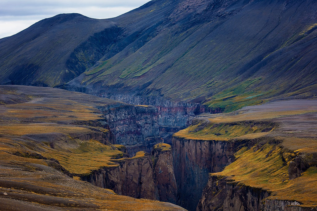
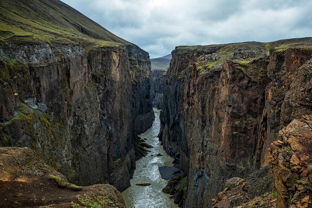
Hafrahvammagljúfur Canyon in the eastern part of Iceland is one of the most impressive canyons on the island. It is more than 200 meters (660 ft) deep and stretches for about fifteen kilometers (9 miles) along the valley of the Jökulsá á Dal River. And you can get there in any car!
How Hafrahvammagljúfur Canyon was formed
The canyon was cut by water erosion into the Kárahnjúkar ridge, which is built of volcanic tuff. The work was done by the Jökulsá á Dal River, and the canyon walls clearly show the successive layers of sediment and volcanic rock the river sliced through. It is up to 200 meters (660 ft) deep, but in places no more than 20 meters (65 ft) wide – massive and yet strikingly narrow. Seen from the viewpoints it looks truly spectacular, and even the view from above, from the parking lot by the dam, is beautiful.
The southern part of the canyon – the stretch closest to the Kárahnjúkastífla Dam – has recently been given a separate name on official maps: Dímmugljúfur. Google Maps does not show it, however, and you will rarely come across the name anywhere else.
Towering over the whole area, southeast of the dam, is Snaefell – a mountain with a name confusingly similar to Snaefellsnes and Snæfellsjökull – a peninsula and a glacier-capped mountain, both at the exact opposite, western end of Iceland.
The dam, artificial lake and hydropower plant in the Hafrahvammagljúfur area
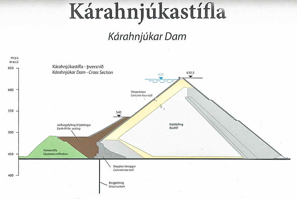
Kárahnjúkastífla Dam cross section
Since the mid-2000s, the Hafrahvammagljúfur Canyon has been closed off to the south by the Kárahnjúkastífla Dam and the artificial Hálslón Lake. Built between 2003 and 2006, the dam is 198 meters (650 ft) high – the tallest dam in Iceland and, according to its operator Landsvirkjun, the tallest concrete-faced rockfill dam in Europe.
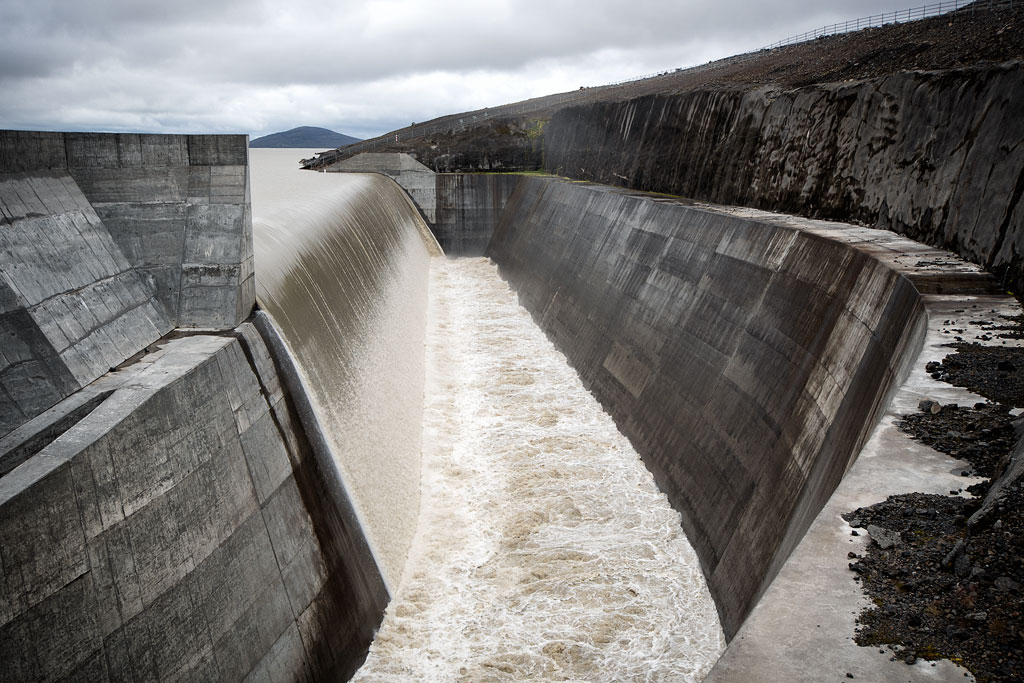
Power plant overflow sill
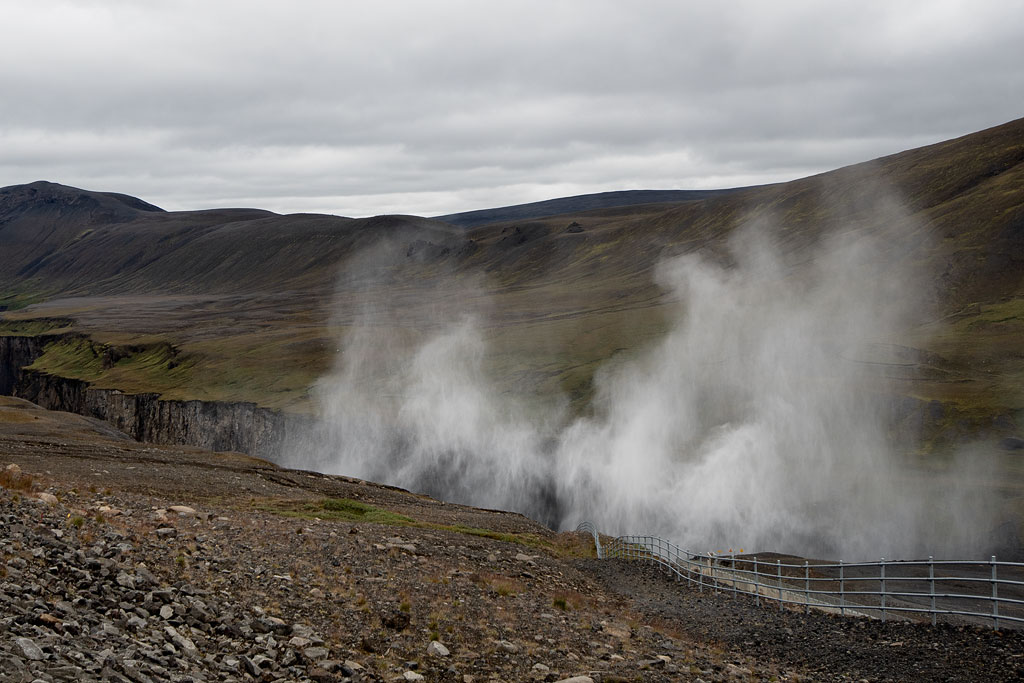
The dam has an outlet at its base that does NOT discharge into the canyon, but when the Hálslón reservoir is full enough, water is also released over a special upper spillway at the western end of the dam. It drops into the canyon as Hverfandi, a waterfall 90-100 meters (300-330 ft) high, with a misty cloud of spray floating above it. A road runs along the crest of the dam, with a beautiful view of the canyon (no stopping on the dam!).
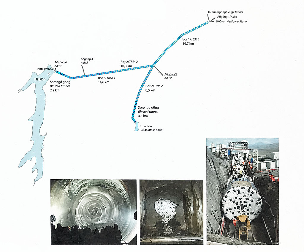
Tunnel diagram of Fljótsdalsstöð power plant
Powered by water from the reservoir, the Fljótsdalsstöð hydroelectric power station sits about 40 km (25 miles) east of the dam, in a hall carved deep inside a mountain. It is also fed from two other nearby reservoirs, again through underground tunnels. The whole tunnel system is about 72 km (45 miles) long, and the station’s capacity is 690 MW, which makes it the largest power plant in Iceland. Almost all of that output goes to an aluminum smelter in Reyðarfjörður, another 40 kilometers (25 miles) to the east.
Hiking trails in the Hafrahvammagljúfur area
The beautiful surroundings of the canyon provide great hiking, and the canyon itself certainly looks most stunning up close.
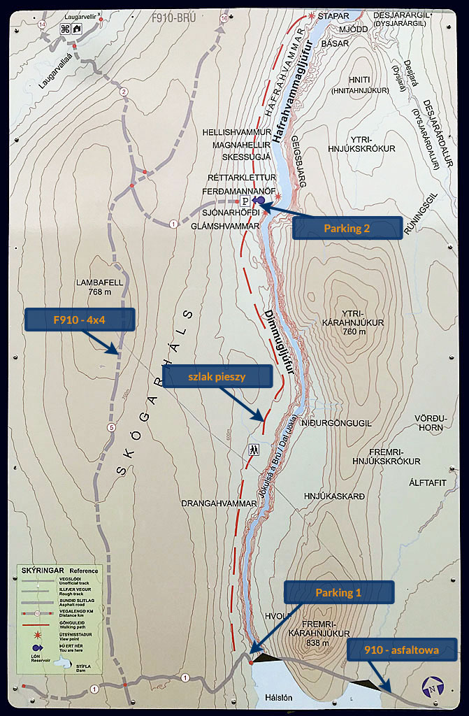
Map of the Hafrahvammagljufur area
The main trail is marked and easy. It starts right at the dam and leads north along the west side of the canyon. On the way it passes the small Magnahellir cave and several beautiful viewpoints. The most popular of them – Ferðamannanöf (literally, Place of Travelers) – lies about 500 meters (550 yards) from the second parking lot, which is about 5 km (3 miles) north of the dam.
The whole trail is about 7 km (4.5 miles) long, but unless someone picks you up at the second parking lot, you obviously have to cover that distance twice.
Visitors are strongly urged not to climb down to the bottom of the canyon. Iceland is tectonically active and small local earthquakes are an everyday event here. Apart from the risk of being hit by rocks loosened by a tremor, there is the risk of a flood wave from the dam nearby – both from water spilling over the top and from a possible need to release water from the artificial lake.
How to get to Hafrahvammagljúfur
Getting to the southern end of the Hafrahvammagljúfur canyon is very easy. From Egilsstaðir in the eastern region you drive southwest on road 931 and then on road 910. Road 910 carries on southwest and west all the way to the parking lot at the Kárahnjúkastífla Dam and the southern end of Hafrahvammagljúfur. The distance from Egilsstaðir itself is about 100 km (60 miles) and the drive takes about an hour and a half. This part of the road is fully paved, and as long as there is no snow or ice on it, any car can make it.
There is also a shelter along this road, the best base for exploring this part of the interior: Laugarfell Shelter – the eastern gateway to Iceland’s interior.
If you want to drive on to the parking lot by the viewpoints, you will need a 4-wheel drive car. From the parking lot near the dam you climb a serpentine road and continue about 1 km (0.6 miles) west, to where the road turns into the gravel F910 (and the road to the power station buildings branches off to the south). From there you head north for about 4 km (2.5 miles) to a junction, where you turn east onto the access road to Hafrahvammagljúfur itself. That road has the status of a mountain road (F) and is fairly narrow and gravelly, but there are no particular difficulties on it, so any 4×4 will handle it. Bear in mind that the F-roads here are usually open only for the summer, roughly from July to the middle of September.
Coming from the crater of Askja, you reach the canyon on the F910, turning south off the section that links the F905 and F907. Until 2019, a long stretch of this road – the part running along the canyon – was missing from Google Maps. It was added in 2020, and hopefully it will stay there 🙂
The area’s biggest attractions are certainly the crater of Askja mentioned above and the small but charming Studlagil Canyon – one of Iceland’s hidden treasures. In summer you can drive from one canyon to the other through the interior, without going back to the Ring Road – on mountain roads and in a 4×4 only. East of the canyon, already outside the interior, do not miss the waterfalls of Hengifoss and Litlanesfoss on the way to Egilsstadir – the capital of eastern Iceland.

I am planning to visit the canyon in the second week of October, weather permitting. However, I only have a normal campervan, which is not allowed on F-roads.
From your post, I gathered that there is a path from the dam along the west side of the canyon that leads to parking lot 2. The path is probably unofficial and not signposted. Is it difficult to get to parking lot 2 this way? I also wanted to visit Magnahellir, which can be reached from parking lot 2. How many kilometers is it to the cave and back to the dam?
I had also considered driving to the junction of the track to parking lot 2, parking at the intersection, and walking down the track. Is the gravel road to the intersection along the F910 really so bad that you shouldn’t try it with a normal vehicle? If you drive slowly, concentrate, and pay attention, it should be doable. Or do you absolutely need high ground clearance?
so this path is indeed a bit “undecided”; from Parking 1 you “just” need to see it and get on it, likely by overstepping a road railing; and then it’s not very well marked, clearly not cared for too much; but then once you get to Parking 2, there’s (or at least was in 2024) a large board showing and describing this trail… So it’s there, you can use it (if it doesn’t snow by then, as snow might make it slippery and potentially dangerous);
as to getting to Parking 2 in a regular car… well, parking at the intersection is the worst option – you should not do that; but actually getting to Parking 2 should not be difficult in a regular car, especially if you’re being careful; it’s an F road, so you will probably be outside of your insurance regulations, but it’s one of the only F roads that are currently marked (by road.is) as ‘easily passable’, which generally means you can drive it in any car; and yes, it’s a “dirt road”, but personally I can’t remember any obstacles on this road that would make it unaccessible for a regular car – just be mindful of the gravel, potential holes and mud;
it’s about 5km (3.5 mi) each way from the parking lot at the damn to the cave; but I’m not sure if the cave is worth your while, esp. in October – there’s plenty of much larger and more interesting caves in Iceland (see Vidgelmir – Iceland’s Most Popular Cave)