


For geologists, an active volcano is one that has had at least one eruption in the last 10,000 years. But in Iceland we even observe ones that had their last eruption only 10 or 20 years ago. That’s why Iceland is a great place to learn about volcanoes and the effects of their life.
Volcanism is the totality of processes involved in the eruption of magma, gases and steam onto the Earth’s surface. The effects of volcanism that are easy to observe in Iceland are mainly volcanic mountains, lava fields, exhalations, geysers and thermal springs. Earthquakes and glacial floods are effects of a slightly different kind. In this article we will look at all of them.
Lava and lava fields
Volcanic ash is a very important product of volcanic eruptions. It is what paralyzed air traffic in 2010 (after the eruption of Eyjafjallajokull). What stays with us far longer after an eruption, though, is lava.
Lava is divided into two large groups depending on its chemical composition: acidic lava and basic lava. Depending on the viscosity of the magma and its gas content, we also distinguish so-called block lava and pahoehoe lava.
Acid lava versus basic lava
Acidic lava is very rich in silica (SiO2) and viscous. It flows lazily down slopes and often carries away much of the rock material it meets. The rocks that form from it are light and usually brightly colored – rhyolites and porphyries, such as the ones we can see in Landmannalaugar or Kerlingarfjoll.
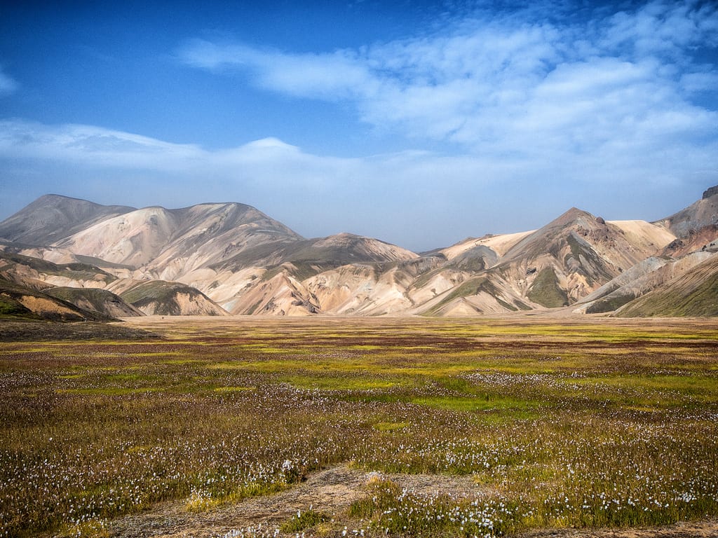
Rhyolite rocks in Landmannalaugar
Basic lava, on the other hand, has a much lower silica content, but much more iron and magnesium. As a result, the rocks that form from it are dark, dense and heavy. Typical examples are basalts and tephrites. Basic lava is much less viscous, which also makes it more mobile: it spills in many directions, flows quickly and drains far from the volcano, so it can cover huge areas with a fairly thin layer. Iceland’s largest lava field – Odadahraun (Ódáðahraun) north of Vatnajokull – is as large as 3,684 km2 / 1,422 sq miles (and, according to some sources, almost twice as large – depending on where you draw the boundaries of the field).
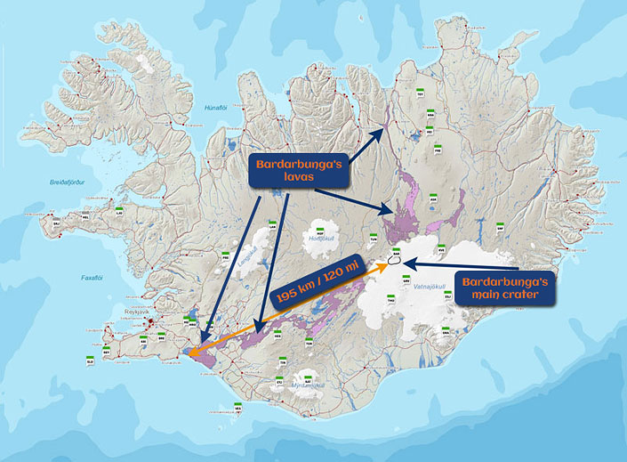
Bardarbunga volcano lava extent [13]
In contrast, lava from the Bardarbunga eruption 8,600 years ago flowed into the ocean as far as 200 kilometers / 125 miles from the source of the outflow. The crater of that volcano lies in the Vatnajokull massif, and the lava reached the ocean near Eyrarbakki and Stokkseyri, south of today’s Selfoss [11]. Viscosity is of course not the only thing that affects how fast lava flows. The amount pouring out of the volcano matters just as much, and so do the altitude and the slope of the mountainside.
Block lava and pahoehoe
Gases that failed to escape from the lava leave behind characteristic bubbles. They make the lava light, rough and prone to crumbling as it cools. This is block lava – apalhraun in Iceland, aa in Hawaii. If the lava does not have that many gas cavities, it is smooth and shiny: pahoehoe lava, helluhraun in Icelandic.
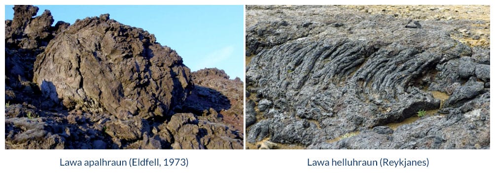
Examples of lava apalhraun and helluhraun (Fraedrich, 2018)
Pumice
Pumice is another characteristic rock that forms when a volcano erupts. It solidifies out of ejected lava that is hot but also very rich in gases, which is exactly why pumice is so light: its structure is full of empty space. Pumice is heavier than ash, so it falls first and always accumulates at the bottom of ash layers. What makes it remarkable is that thanks to its porosity it floats on water. That is why pumice from Japanese volcanoes sometimes drifts all the way to Hawaii!
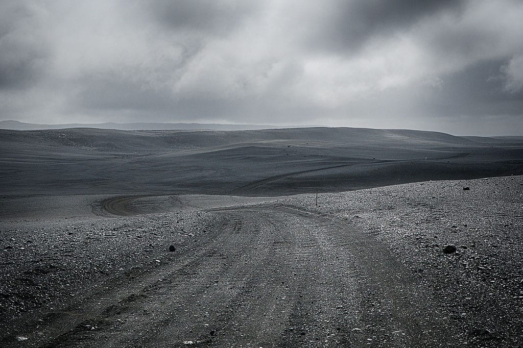
Pumice landscape on the F26 road (full color photo!)
Obsidian
Another interesting form that lava sometimes takes is a glaze that looks almost like black glass – this is obsidian. This unusual form of lava needs very special conditions: the lava must cool extremely fast and must not have time to crystallize. That happens, for example, when hot lava meets water. Obsidian has a glassy luster and a characteristic conchoidal fracture. It is a rock intriguing enough to keep appearing in fantasy literature. In Game of Thrones it was known as dragonglass and was the best weapon against the White Walkers and the undead… In The Lord of the Rings, obsidian was the material of the indestructible tower of Orthanc in Isengard, where Saruman lived.
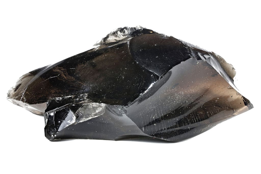
Obsidian
Obsidian is relatively common in Iceland, but it is usually covered by a layer of other rock. In the mountains and the highlands you can also find bare fragments, usually as black stones among other rocks. Without expert knowledge it is often hard to recognize, because natural erosion leaves obsidian looking quite inconspicuous in the wild. Many souvenir stands sell jewelry and pieces of natural Icelandic obsidian, and that is probably the easiest place to see it at its most beautiful.
Basalt columns
Another very interesting and extremely impressive form of lava solidification is so-called columnar (thermal) jointing. Its characteristic product is basalt columns, looking as if the rock was divided into regular vertical columns of polygonal (six-, five- or four-sided) cross-section. This form develops in the last stage of lava cooling. Cracks are formed perpendicular to the cooling surface due to tensile stresses, which in turn are created by the shrinkage of the lava during solidification. They form best when the cooling is uniform, very slow, and the lava is homogeneous (that is, usually basaltic). Such columns can be found quite often in Iceland – for example, on the beach of Reynisfjara, by the rocks of Borgarvirki, at the canyon Studlagil or by the waterfalls Litlanesfoss, Svartifoss or Aldeyjarfoss. Such columns were also the inspiration for the shape of Reykjavik’s largest church – Hallgrimskirkja.
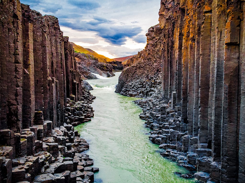
Basalt columns in Studlagil Canyon
Hot exhalations
Volcanic activity is inevitably accompanied by fumes of gases and vapors called exhalations. They are emitted not only during the eruption itself, but also before and after it. There are three such forms: fumaroles, solfataras and mofettes, and the main criterion that tells them apart is the temperature of the escaping gases and vapors. During an eruption fumaroles form closest to the volcano, then solfataras and, at the very end, mofettes.
Video: Fumaroles in Hveravellir.
Fumaroles
Fumaroles are the hottest, and can range from 200 °C (390°F) to as much as 1,000 °C (1,830°F). Their main products are steam, carbon dioxide, iron, chlorine and sulfur. Their “fumes” often also contain hydrogen sulfide (a noxious gas with the characteristic smell of rotten eggs), hydrogen chloride (which combines with water to form hydrochloric acid) and hydrogen fluoride (which forms hydrofluoric acid, very dangerous to humans). Fumes of this type occur near the craters of active volcanoes. Being anywhere near exhalations carrying such harmful products is very dangerous for most living organisms, humans included.
Solfataras
Another type of exhalation is the solfatara. The name comes from Italian, where solfa means sulfur – a reference to the fact that solfataras can produce so-called native sulfur. Solfataras are fumes of moderate temperature, from 100 °C (212°F) to 200 °C (390°F). Their main products are superheated steam and small amounts of hydrogen sulfide and carbon dioxide. Because their temperature is no longer that high, they occur near dormant or extinct volcanoes.
Mofettes
Mofettes are the coolest of the exhalations, with temperatures below 100 °C (212°F). They consist mainly of carbon dioxide and occur farthest from the craters of dormant or extinct volcanoes, where the ground is no longer that hot.

Scientists while measuring the mass of steam from a small exhalation (Fridriksson, 2006)
Geysers
Geysers are also a spectacular but quite rare manifestation of volcanism. These are springs that periodically eject water, steam and sometimes rock material into the air. They are typical of very young volcanic activity and are known mainly from Iceland, the American Yellowstone, New Zealand and Kamchatka. Some of them erupt once a year or less often, others every few to several dozen minutes. The “godfather” of all the world’s geysers is Geysir, about 75 km / 47 miles as the crow flies from Reykjavik.
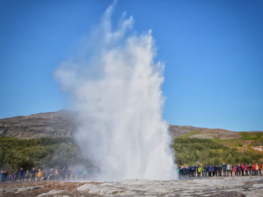
Strokkur geyser eruption
The mechanism of a geyser is quite simple, but it needs very specific natural conditions, which is why geysers are so rare. In an active geyser the water in the channels below the surface is heated by volcanic activity. In the lower part, where it is hottest, the water reaches more than 100 °C (212°F), but it does not boil, because the high pressure raises the boiling point – in some geysers the water deep down gets as hot as 180 °C (355°F).
Despite the increased pressure, the steadily high temperature of the volcanic rocks eventually pushes the water past its boiling point and bubbles of steam form in it. The small bubbles merge into larger ones and lift the water column slightly, throwing part of the water out. That causes a sudden drop in pressure at the bottom of the geyser, and with it a drop in the boiling point. Water that has been heating up to, say, 150 °C (300°F) suddenly finds itself where the boiling point is “only” 110 °C (230°F) or 120 °C (250°F). As you can easily guess, at that moment a huge amount of water boils extremely rapidly. Huge amounts of steam are released, and the water above the exploding steam flies high into the air.
Today Geysir itself erupts irregularly and low, but in the 19th century eruptions were recorded in which it threw water as high as 120 meters / 390 feet. Tourists in Iceland today tend to watch the slightly smaller geyser Strokkur, right next to Geysir, which only reaches 15-20 m / 50-65 ft, but does it regularly every 8 to 10 minutes… The sight is absolutely mind-blowing 🙂
Video: How the Strokkur geyser works (and how it explodes!).
Thermal springs
Another companion to volcanic activity are thermal springs, also known as hot springs or thermae. They occur in areas of active or recently extinct volcanic activity. Hot springs are formed from surface water that seeps deep into the ground through permeable layers or fissures and warms up at a certain depth. It then looks for the easiest way out, most often a fault, and comes to the surface under pressure. The term covers every spring whose water is warmer than the annual average temperature in the area, and every spring that stays above 20 °C (68°F).
In Iceland there are a great many bathable thermal springs, that is, those where the temperature at the outflow does not exceed 35 °C (95°F). Where a spring is hotter than that, people usually find a way to mix it with cold water and get a pleasant hot bath. Landmannalaugar and Hveravellir are good examples. In large pool and spa complexes, such as the Blue Lagoon, everything is of course under the careful control of technology. Given the Icelandic climate, a hot spring is a very welcome change and a chance to relax during the day or at the end of it.
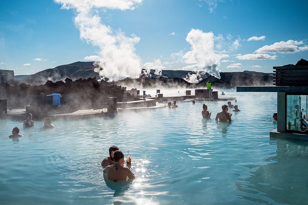
Thermal pools and SPA: Blue Lagoon
Interestingly, Iceland’s capital Reykjavik owes its name precisely to its hot springs: the name translates as bay of steam, or smoky bay.
Earthquakes
Tectonic and volcanic processes never stop in Iceland, and one of their effects is seismic: earthquakes. These are tracked by the Icelandic Meteorological Office (IMO), the national weather service – but given the nature of the country it also tracks volcanic eruptions, lava flows, earthquakes, volcanic floods and the other effects of the island’s volcanism.
There is no need to worry, though – the vast majority of them are very weak. Their strength, the so-called magnitude, is below 1.0, and often given as 0.0. These are tremors only specialized instruments can detect, caused for example by lava moving through the underground chambers of volcanoes. Tremors people can feel – those above magnitude 3 – happen in Iceland “only” about once a month. Most of them take place in uninhabited areas, some even in the ocean around the island, so as a rule nobody feels those either.
Strong quakes – above magnitude 6 – usually occur about once a decade [12]. The most recent one struck on May 29, 2008, near the town of Selfoss in the south of the country. The tremor was clearly felt in Reykjavik as well, 50 km / 31 miles away. Nobody was killed, but 30 people were injured and many farm buildings around Selfoss were damaged.
Statistics suggest that since that last strong quake happened back in 2008, and such quakes come on average every 10 years, another one could happen soon. Then again, while two strong quakes sometimes occur in the same year (2000, for instance), the gap between them can just as well be 40 years (1929 – 1968). So there is no point postponing a trip until “after the next big earthquake” – it might just as well come later this year as in 20 years or more. It is simply that going to Iceland takes a bit of luck 🙂
Glacial floods
Any flood is of course a natural disaster and almost always causes a lot of damage. Compared with a volcanic eruption, though, it may seem an unlucky event rather than a dramatic one. Its special case – a glacier flood – does not sound particularly terrible either, and neither the technical name GLOF (glacial lake outburst flood) nor the Icelandic jökulhlaup carries any particularly frightening emotional charge.
Nothing could be further from the truth. Glacial floods can be a massive disaster, the force of which is hard to imagine.
A glacier flood owes its catastrophic character to the fact that in the first phase the outflow of water is usually held back by natural barriers – a wall of ice that has not melted yet, a moraine or another earth embankment. Lava pouring out of the volcano melts the ice, but the meltwater does not run off straight away. It gathers in a natural reservoir, and only when the walls of that reservoir give way does the water pour out. And then it does not do it slowly – such a flood is absolutely catastrophic.
The most recent example of such a flood in Iceland is the jokulhlaup of the Grímsvötn volcano in 1996.
In early October 1996, an eruption on the Vatnajökull glacier melted about 3 km3 of ice. The resulting water collected in a subglacial reservoir in the Grímsvötn caldera, the surface of which was about 1,500 meters [4,900 feet] above sea level.
On November 4, 1996, at about 9:30 PM, the ice wall of this reservoir began to crack. At 7:20 AM the following day, a flash flood occurred 50 km [31 miles] away at the eastern face of the Skeiðarárjökull outflow glacier. […] In the later hours of that day, the flood gradually covered more areas to the west, along the glacier front located at an altitude of about 100 meters [330 feet] above sea level.
By 3:40 PM floodwaters were leaking from almost the entire 20-kilometer [12-mile] stretch of the glacier front. […] The two main channels through which the flood waters flowed – Gígjukvísl and Skeiðará – at their peak reached flow rates of 33,000 m3/s and 23,000 m3/s, respectively.
Fifteen hours after the flood began in the glacier’s headwaters, the combined maximum flow velocity exceeded 50,000 m3/s [about 65,500 cubic yards per second], making these rushing streams of water the second largest river in the world at that point.
Beyond the glacier, an area of 750 km2 [290 sq miles] was flooded. The shoreline advanced as much as 800 meters [880 yards] from the mouth of the Gígjukvísl River. This created a new land area of about 7 km2 [about 3 sq miles].
The jökulhlaup on Skeiðarársandur…; Oddur Sigurðsson et al.; [10]
On Road 1, about 5 km / 3 miles southwest of Skaftafell and the waterfall Svartifoss, we can still see the remains of the bridge over the Skeiðará River, which stood there until that flood… The bridge’s huge iron girders, bent like plasticine, give a very vivid idea of the power of a glacial flood. Lava is not the only mighty “weapon” of the volcanoes…

Skeidara River bridge destroyed in the 1996 glacial flood
More on Icelandic volcanoes
If the effects of Iceland’s volcanoes are your thing, be sure to also read our articles on how volcanoes form and function: Iceland’s Volcanoes, on which eruptions we count as the biggest volcanic eruptions in Iceland and why, and on how Iceland itself was formed in the first place and why it has so many volcanoes: How Iceland was formed – the geology of the island in a nutshell.
If you want to see the most interesting volcanoes that are easy to see on a trip to Iceland, take a look at the index of sites on the subject: Iceland’s most interesting volcanoes.
Bibliography
- Czechowski, L. 1994. Tektonika płyt i konwekcja w płaszczu Ziemi (Plate tectonics and convection in the Earth’s mantle, in Polish). Wydawnictwo Naukowe PWN, Warsaw
- Fraedrich, W. 2018. Iceland from the West to the South. Springer International Publishing (27-92)
- Fridriksson, T. 2006. CO2 emissions and heat flow through soil, fumaroles, and steam heated mud pools at the Reykjanes geothermal area, SW Iceland. Elsevier
- Jaroszewski, W., Marks, L., Radomski, A. 1985. Słownik geologii dynamicznej (Dictionary of dynamic geology, in Polish). Wydawnictwa Geologiczne, Warsaw
- Książkiewicz, M. 1979. Geologia dynamiczna (Dynamic geology, in Polish). Wydawnictwa Geologiczne, Warsaw
- Lamur, A. et al. 2018. Disclosing the temperature of columnar jointing in lavas. Nature
- Pożaryski, W. 1977. Islandia w świetle tektoniki płyt (Iceland in the light of plate tectonics, in Polish). Przegląd Geologiczny
- Stanley, S. M. 2002. Historia Ziemi (Earth System History, Polish edition). Wydawnictwo Naukowe PWN, Warsaw
- Thordarson, T., Larsen, D. 2006. Volcanism in Iceland in historical time: Volcano types, eruption styles and eruptive history. Elsevier
- Oddur Sigurðsson, Páll Jónsson, Árni Snorrason, Skúli Víkingsson, Ingibjörg Kaldal and Svanur Pálsson. The jökulhlaup on Skeiðarársandur in November 1996: Event, discharge and sediment. (PDF, 11 KB) National Energy Authority, Grensásvegi 9, Reykjavík
- Volcanic system: the Bárðarbunga system. Edited by: Gudrún Larsen and Magnús T. Gudmundsson; Institute of Earth Sciences, University of Iceland; August 25, 2014
- Earthquake Track
- Directory of Icelandic Volcanoes – icelandicvolcanoes.is
