According to classical climatic definitions of the seasons, winter is the period in which the average daily air temperature falls below 0 °C (32°F), and summer is the period in which the average daily air temperature exceeds 15 °C (59°F). [Source: Wikipedia – winter, Wikipedia – summer]. In this sense, in Iceland there is neither winter nor summer – all year round there is a peculiar sort of spring-autumn…
Iceland’s climate has grown a thick crust of myths and misconceptions. So here – precisely and practically, based on the best statistical data and our own experience – we describe what weather to expect when you come to this beautiful island.
Iceland weather – READ THIS FIRST
Iceland is actually a small island located in the middle of the vast and cool Atlantic. Therefore, regardless of the season, its weather always has several distinctive features. Here are the most important basic features of Iceland’s year-round weather:
- Anything can happen
Regardless of the weather typical for a particular season or month, Iceland can quite easily experience storms and several days of completely extreme weather (please see the ‘storms and natural disasters‘ section below). For example, the average daytime temperature in May is 10.3 °C (50.5°F) and more than half (56%) of May days actually have a maximum daytime temperature close to this average – between 8 °C and 12 °C (46 – 54°F). But the warmest day reached as much as 18.5 °C (65.3°F; May 9, 2006), and the coldest only 1.9 °C (35.4°F; May 1, 2013). The coldest May night had a temperature of -5.9 °C (21.4°F). “Expect the unexpected,” one might say… - Cold weather is year-round
Winters are mild – the average daily temperature in January is 3.3 °C (37.9°F) – but, as is typical of a maritime climate, the summers are “middling” as well. The daily temperature exceeds 15 °C (59°F) only in July, and only symbolically at that – exactly 15.1 °C (59.2°F). So the winter (in this respect) is fairly mild, but the summer is noticeably colder. - It always blows hard
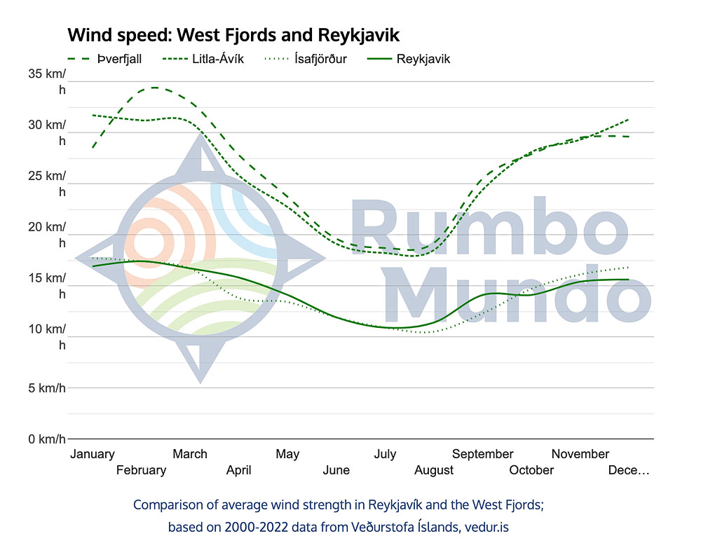
The impression of year-round cold is compounded in Iceland by strong winds. In the windiest regions, there has yet to be (at least since 2000) a winter without winds above 100 km/h (62 mph). Particularly windy are the West Fjords and the interior, but strong wind is a constant visitor in Reykjavik and along the south coast too, at any time of year. - Days are not much warmer than nights
Strong winds, heavy cloud cover, direct proximity to the cold ocean and a location just below the Arctic Circle mean that the sun is unable to warm the air even in summer, when the day lasts more than 20 hours. The minimum night temperature and maximum daytime temperature on average differ by no more than 6 °C (11°F). So, unlike a continental spring, it rarely happens that a cool morning turns into a really warm afternoon. Usually the morning is cool, and the day stays cool too… - Summer is the least rainy season
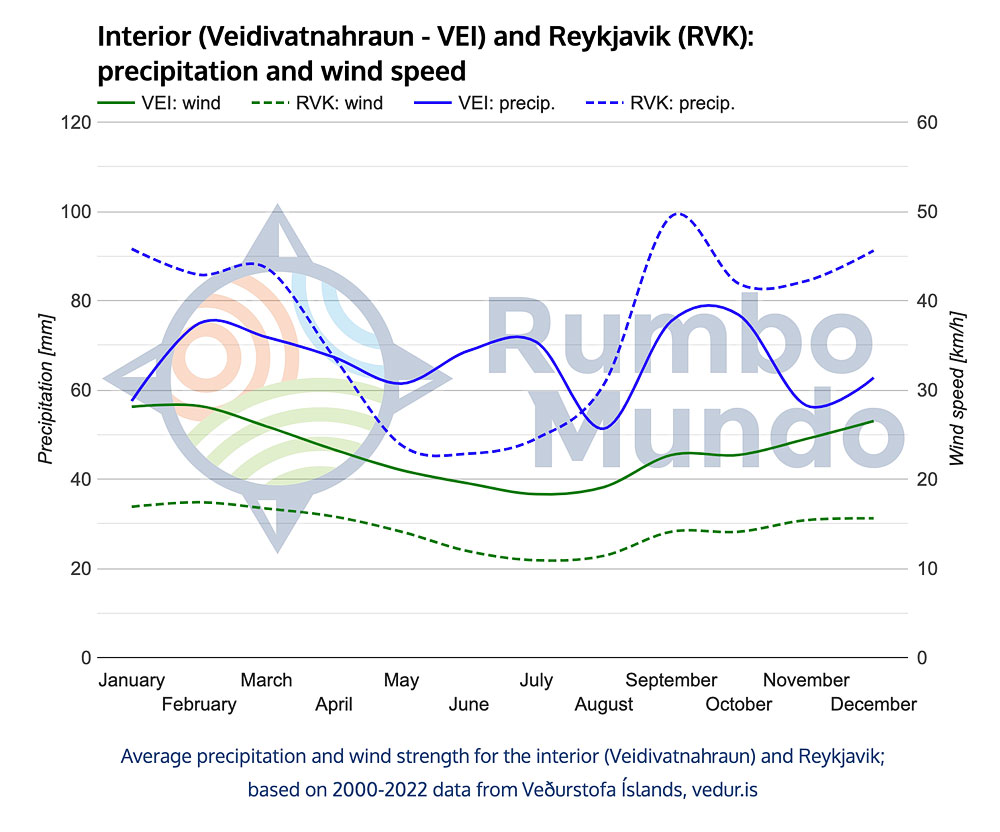
Unlike mainland Europe, Iceland records its lowest rainfall in early summer – from May to July. Monthly precipitation totals are then up to half those recorded from September to March. Unfortunately, in summer too, the rain tends to come as prolonged drizzle or light rain rather than a concentrated 15-minute downpour. So it’s hard to get completely soaked, but it’s also hard to wait out the rain. - Regional differences are relatively minor
Iceland is a small island, so the statistical differences between its various parts are small. The central highlands, known as the interior, stand out: they are noticeably cooler and windier than most of the country. To some extent they are matched by the far northwestern West Fjords. These are also the regions where snow lies longest. Eastern Iceland is the rainiest, while the south has the relatively mildest climate. - There is a fairly pronounced warming of the climate
Comparing the data for 1977-1999 and 2000-2022, it is clear that Iceland has become noticeably warmer and less windy. The average maximum daytime temperature has risen in some months by as much as 2 °C (4°F), and the lowest nighttime temperature is now fully 5.5 °C (9.9°F) higher! Average wind speed, meanwhile, has fallen by 30%. So Iceland’s weather has in a sense become friendlier – but, as every guide will confirm, the glaciers are retreating extremely fast. - Weather is also created by volcanoes and glaciers
An additional element in the unpredictability of Iceland’s weather is its volcanoes. While eruptions are rare, when they do happen they can turn the entire tourist world upside down. And the non-tourist one, too, of course. Note that a volcano doesn’t have to erupt to mess with our plans. The largest of them are covered by ice caps, and all it takes is for lava rising towards the surface to warm such a glacier a little, and a so-called glacial flood can close all the roads in the area… The possibilities are indeed many.
Unless we state otherwise, all the information in this article refers to the weather in Reykjavik and is based on an analysis of weather data collected by Veðurstofa Íslands (Iceland’s national weather service) for the years 2000 – 2022. Reykjavik is a good representation of the weather for Iceland as a whole. Regional differences in weather are small (we describe them in a separate article: Weather in different regions of Iceland).
Sunrise and sunset times (and similar data) are taken from Photo Pills.
Sunrise and sunset times (and similar data) are taken from Photo Pills.
Iceland’s climate – temperature, wind, precipitation
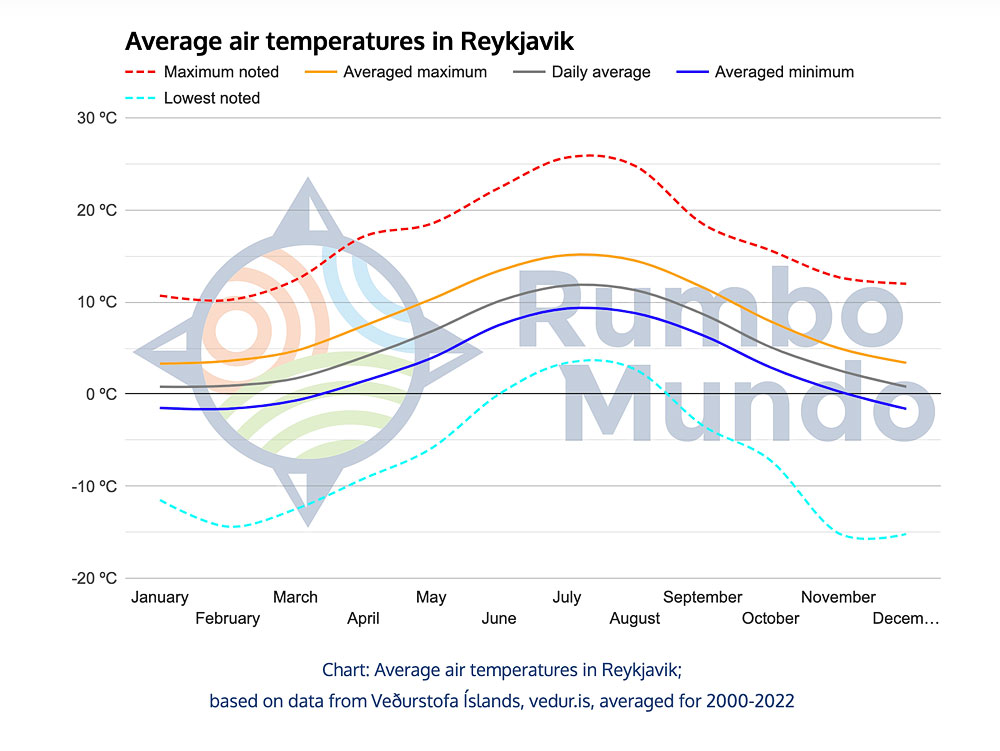
The typical (and unusual) weather for each month in Iceland can be read from the charts below. Hover over a chart with your cursor to see the exact data for the selected month.
based on data from Veðurstofa Íslands, vedur.is
Reykjavik, averaged for 2000-2022
But you should also be prepared for extremes – the temperature, unfortunately, can approach both the dashed red line (the highest temperature recorded in a given month) and the dashed aqua line (the cold record for a given month). Importantly: the graph shows data collected in the standard way, i.e. 1 m above the ground. Temperatures near the ground are often much lower. For longer trips, the chance of encountering weather extremes clearly increases.
The high tourist season lasts from May to August in Iceland not only because of the relatively high temperatures, but also because of longer days, more sunshine, less rainfall and lighter winds.
In the chart below – probably even better than the temperature chart – you can see why the high tourist season lasts in Iceland from May to August. All weather factors line up favorably then.
based on data from Veðurstofa Íslands, vedur.is
Reykjavik, averaged for 2000-2022
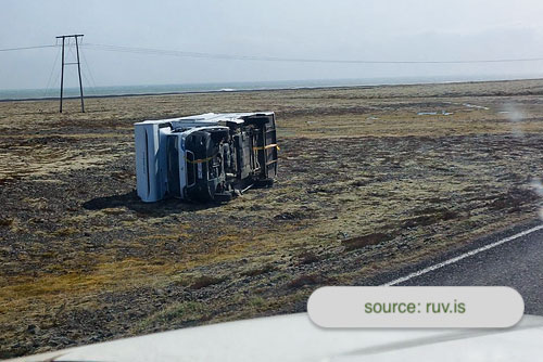
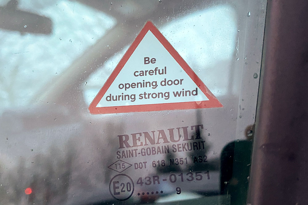 Always be careful when getting out of the car! Even if (officially) there is no storm and no weather alert is declared, very, very strong winds (especially in temporary gusts) can blow in many places in Iceland. With a bit of bad luck, if you’re not careful when you get out, the wind can rip the door out of your hand and break its hinges. It is actually a fairly common insurance claim in this country.
In a separate article we cover how the weather affects visiting Iceland, when the best time to go is, what to watch out for and how to plan your trip for the season you choose: When (and how) to go to Iceland. There you will also find ready-made route suggestions and itineraries for every season.
Storms and natural disasters in Iceland
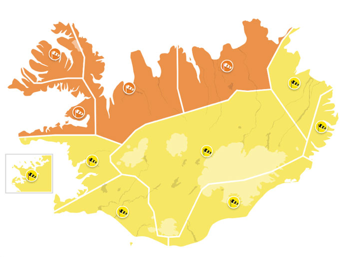
Storm weather alerts
Iceland, as an island in the middle of the Atlantic, is highly vulnerable to storms. They can put a stop to sightseeing and to daily life on the island, and even to flying in or out of it. Winter storms also often cause huge snowfalls – then travel around Iceland can be difficult in places for another 2-3 days.
A major storm can happen in any month, of course, but they are most frequent from September to March. In autumn (as the statistics and charts more or less show), spells of bad weather last longer but are somewhat milder. At the beginning of the year, by contrast, storms tend to take a more violent form, though perhaps more often “interspersed” with periods of beautiful, sunny weather. Except that in December and January the sun rises above the horizon for only a few short hours a day.
Heavy, devastating storms are truly dangerous, but not very frequent. And they are always preceded by an appropriate – yellow or red – weather alert from the Icelandic Met Office (albeit the alert sometimes comes hours, rather than days, in advance). So don’t let the danger scare you away from Iceland. Just stay alert, follow the weather reports, always be mindful of the wind, drive carefully and – if needed – don’t go to the affected areas or leave them BEFORE the storm arrives.
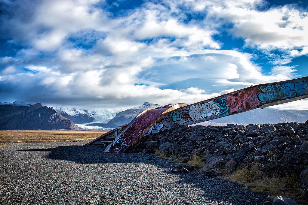

Remains of the bridge over the Skeidara River, destroyed by the 1996 glacial flood
An additional threat specific to Iceland is volcanoes. The eruption of Eyjafjallajökull in early 2010 paralyzed air travel throughout Europe. In 1996, a glacial outburst flood – known here as a jökulhlaup – completely destroyed Route 1 on the south coast and the bridge over the Skeidara River. In contrast, the latest eruption – known by three names: Fagradalsfjall, Geldingadalir and Meradalir – was purely a tourist attraction and disrupted neither road nor air traffic.
Several volcanoes in Iceland are constantly active. The Icelandic authorities monitor this activity and issue warnings when necessary. These are not common events (from a tourist’s perspective), but they do happen.
Do keep at the back of your mind that your plans can also be thwarted by a volcanic eruption, a glacial flood or a major landslide – rare, but real.
Winter weather in Iceland
By the classical criteria quoted above, there is essentially no winter at all in the south of Iceland, as the average daily air temperature here stays above 0 °C (32°F) in every month. On the other hand, from November until March there is fairly uniform weather, which can hardly be described as anything other than just winter.
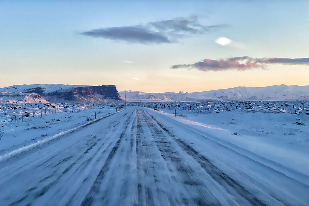
Icy Road 1 in winter
Average maximum daytime air temperatures (in the south) from November to March range from 3 °C to 5 °C (37 – 41°F), and average lowest nighttime temperatures from 0 °C (32°F) to -2 °C (28°F) (in November it is 0.3 °C / 32.5°F, but let’s not split hairs). During this period we also have few hours of sunshine (less than 3 hours a day except in March, when it is a bit more), high rainfall (more than 85 mm a month) and really strong wind. The average wind speed throughout this period (in Reykjavik) is more than 15 km/h (9 mph), but the average gusts exceed 30 km/h (19 mph) in each month, with the strongest gusts reaching up to 90 km/h (56 mph).
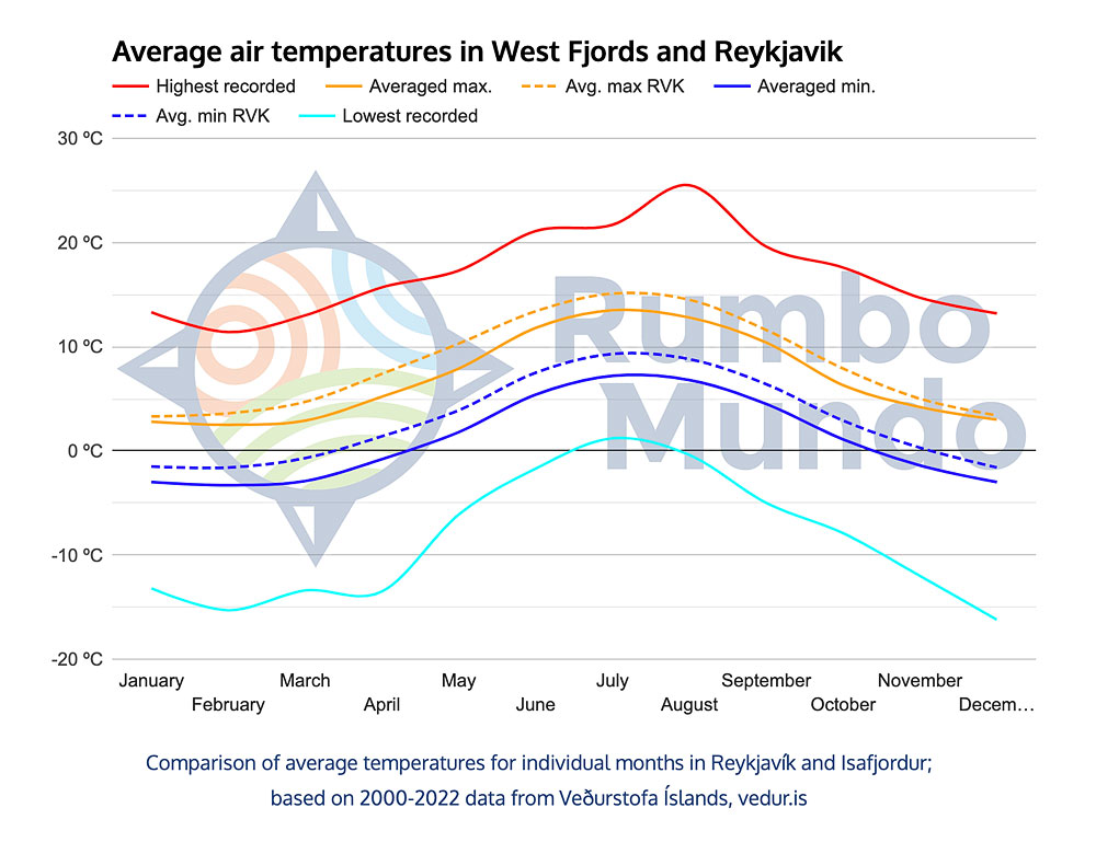
In the north – in Akureyri and Isafjordur – pronounced winter also lasts just from November to March, but it is slightly colder there. Average daily air temperatures then fall between -1 °C (30°F) and +1 °C (34°F), average lowest nighttime air temperatures drop below 0 °C (32°F), though they stay above -4 °C (25°F), and maximum daytime temperatures are (on average!) between 2 °C (36°F) and 5 °C (41°F). As in the south, this is also the period of the strongest winds and high rainfall.
Remember that statistical averages are not everything. As we pointed out at the beginning of the article, in Iceland individual days very often deviate quite far from the averages. That’s why, for example, winter temperatures of -20 °C (-4°F) are not unusual in Iceland.
The lowest temperatures recorded in Reykjavik from November to March fall below -10 °C (14°F), and in the north even to -15 °C (5°F). By the way, this is the temperature measured according to the world standard, so 1 m above the ground. Meanwhile, temperatures at the very ground drop to -20 °C (-4°F) and beyond during this period, including on the southern coast. Strong winds further intensify the sensation of cold and sharply reduce the so-called “feels-like” temperature.
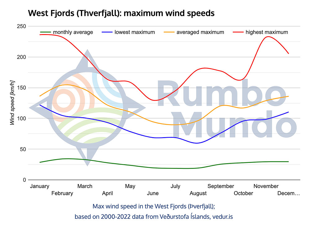
Hills above Isafjordur are not representative of Iceland as a whole, but as a matter of interest we can report that between 2000 and 2022 in every December, January, February and March the weather station on Þverfjall hill recorded winds of more than 100 km/h (62 mph) at least once. And in November at least 98.6 km/h (61.3 mph). The wind, of course, loses that hurricane-like force further inland, but strong winds can occur anywhere.
From November to March Iceland sees plenty of storms and, as a rule, snow just about everywhere. In the north the snow cover persists throughout the winter, in the south it tends to “appear and disappear”. Even in the south, though, a strong snowstorm can cut off large parts of the country for several days.
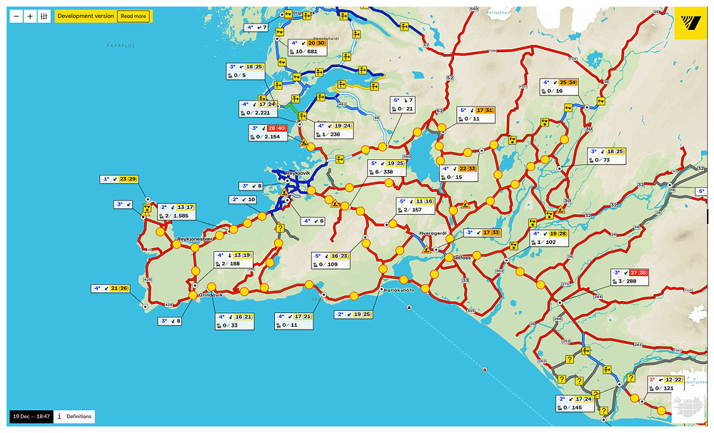
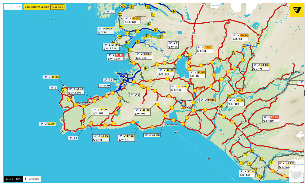
Closed roads in southwest Iceland; December 19, 2022
A snowstorm in December 2022, for example, immobilized the entire southwestern part of the country for as long as three days. Just before Christmas, Keflavik Airport not only stopped operating – it was not even possible to get to or from it. Tourists were also “stranded” in Reykjavik itself and at the famous Blue Lagoon, among other places. All roads in the south of the island were then completely impassable for 2 or even 3 days in places. For the Reykjavik area it was an exceptionally extreme snowstorm, but in the north of the country, locally, such situations are not some wholly exceptional rarity…
A typical Icelandic winter is quite mild and not very cold. But when an “Arctic vortex” sets in, winter in Iceland can be very tough and dangerous. You can read about how to organize a trip to Iceland in winter and how to prepare for it in this article: Winter trip to Iceland – a complete guide.
Weather in Iceland in November
We usually think of November as autumn, but in Iceland it is actually the first winter month. This is especially true in the north of the country. The average daily temperature – even in the north – is still above 0 °C (32°F) (but below 5 °C / 41°F), but many days – and especially nights – are already really cold. The average night-time temperature there drops below 0 °C (32°F), and the strongest frosts reach -10 °C (14°F).
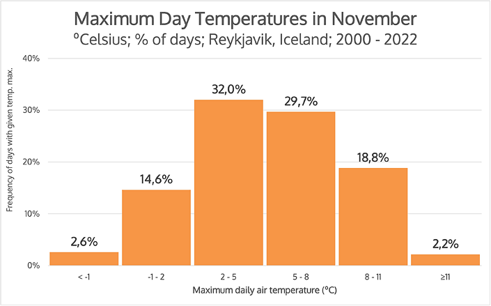
Number of days with a given daily temperature in November.
(max daily temp, Reykjavik, 2000-2022)
In Reykjavik and on the south coast, daytime temperatures hover around 5 °C (41°F) and more than 60% of days have temperatures between 2 °C (36°F) and 8 °C (46°F). Roughly one in five days (21%) has a temperature of 8 °C (46°F) or higher, but at the same time as many as 15% of days (that is, about 1 in 7) have a temperature of about 0 °C (32°F) and frosty days are already appearing. Admittedly, those account for less than 3% of days, but they do occur. The coldest November night since 2000 saw temperatures of -15.1 °C (4.8°F), and -18.5 °C (-1.3°F) at ground level.
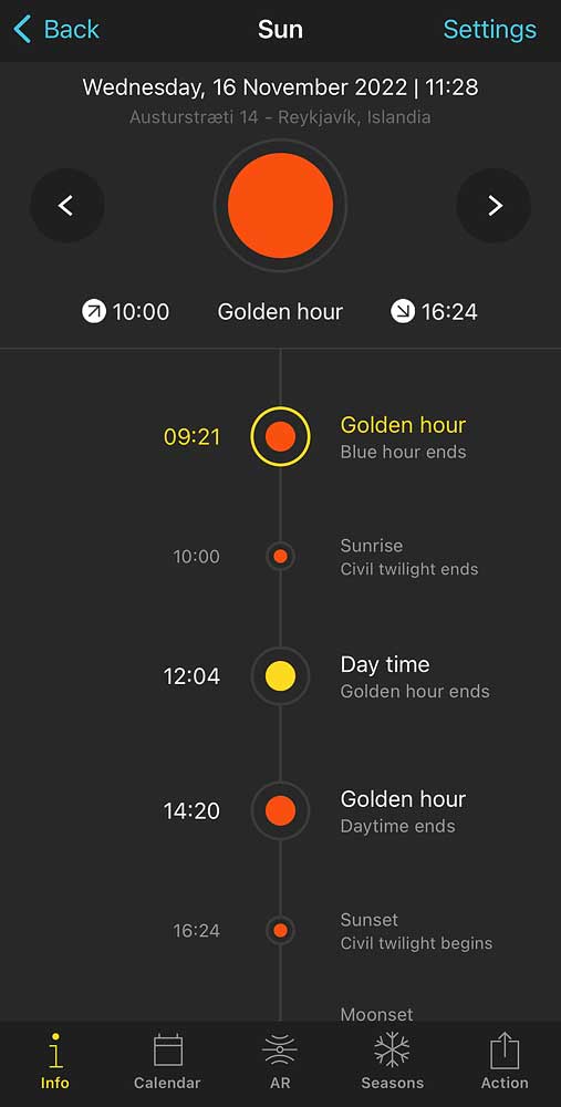
Sunrise and sunset in November
The day also becomes noticeably shorter. In the middle of the month – on November 16 – the sun in Reykjavik emerges from behind the horizon as late as 10 a.m., and sets as early as 4:20 p.m. The sun is reasonably high – a full 6° above the horizon – only from about noon to 2 p.m. If there are no clouds at the time, it is “reasonably” light from about 8 a.m. to 5 p.m., but it is usually cloudy, so it is fairly dark anyway.
Precipitation stays at the high level it reached back in September. However, now – combined with low temperatures – snowstorms are also already appearing.
Wind speed is rising too. The strongest winds will not come until February, but the November average – 15.4 km/h (9.6 mph) – is clearly higher than October’s, and it will not fall back until April.
Although snow in November is not yet a regular visitor, especially in southern Iceland, a November completely without snow would be rather strange.
Like September and October, November is a stormy, disagreeable month – and on top of that the frosts have begun, so conditions for sightseeing in Iceland turn genuinely unpleasant.
Weather in Iceland in December
The end of the year is cold, windy and snowy (or rainy), like all winter, but the most important feature is the super-short days. The average number of hours of sunshine in December in Reykjavik drops to 0.5 hours (yes – only half an hour a day, on average for the whole month!), and in the north, in Akureyri, simply to zero. At the winter solstice – December 22 – the sun in Reykjavik begins to rise at 11:23 a.m., but never rises fully – it slides straight into a sunset that ends at 3:30 p.m.
Naturally, it is also colder than in November. The average temperature drops to a maximum of 3.4 °C (38.1°F) by day and a minimum of -1.6 °C (29.1°F) at night.
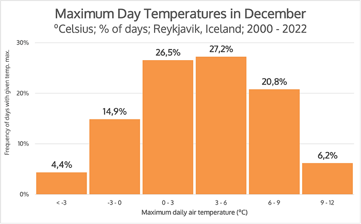
Distribution of daily temperatures in December
(% of days with a given max. daily temp., Reykjavik, 2000-2022)
As you can see on the graph, almost three-quarters (74.5% to be exact) of December days have daily temperatures between 0 °C (32°F) and 9 °C (48°F), and just over a quarter (27%) between 6 °C (43°F) and 12 °C (54°F). Typically, or most often, December in Iceland is thus NOT very cold, although nighttime temperatures almost always drop below freezing.
These relatively warm days are offset, in a way, by days that are few but very cold. For example, on December 30, 2022, the maximum daytime temperature was only -8.2 °C (17.2°F), and the minimum at night was a record -15.2 °C / 4.6°F (this was the lowest temperature recorded since 2000). Even lower are the temperatures measured near the ground – here the record belongs to December 2, 2019 and is -20.3 °C (-4.5°F).
It was also in December 2022 that the aforementioned snowstorm occurred, which cut off all of Reykjavik and Keflavik Airport, among others, for 2 days.
Combined with persistently high precipitation and strong winds, this makes the “feels-like” temperature in December really low.
By way of “consolation”, let us point out that the highest December temperature recorded in Iceland since 2000 was 12 °C (54°F) – on December 6, 2002. So it varies 🙂
Weather in Iceland in January
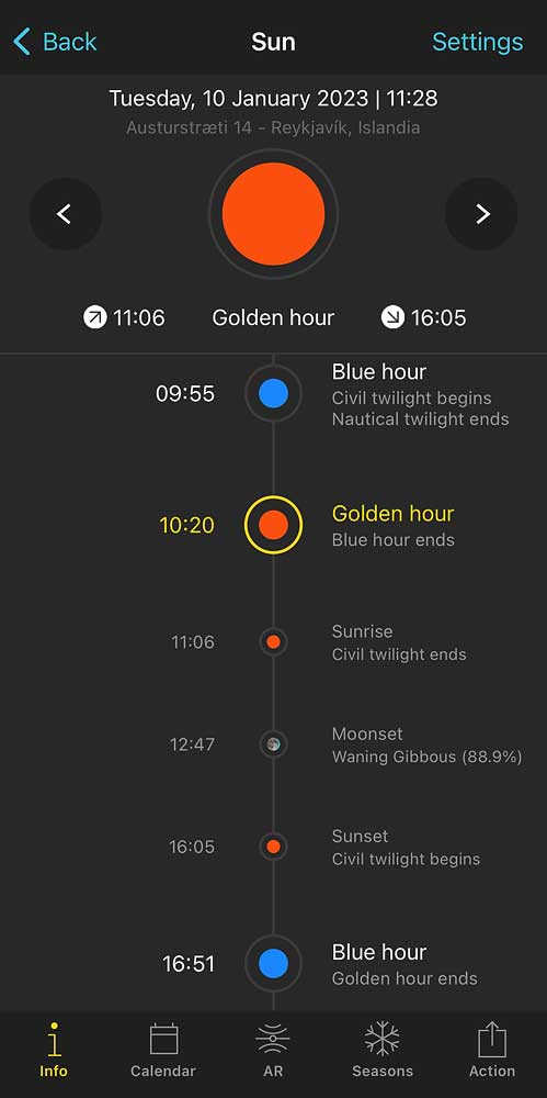
Sunrise and sunset in January
The beginning of the year is of course (still) the middle of winter. What strikes you immediately is the super-short day. The sun doesn’t appear above the horizon until after 11 a.m., but it never rises above 6° and just after 4 p.m. it disappears completely below it again. It is relatively bright between 10 a.m. and 5 p.m., but only “relatively” and only if there are no clouds.
January is also a month of very strong winds. The average wind speed in Reykjavik is 16.9 km/h (10.5 mph), but gusts reach up to 76 km/h (47 mph). On the West Fjords peninsula, it was in January that the strongest winds were recorded – the record reading was as high as 236.2 km/h (146.8 mph)!
January is also one of the months with high precipitation totals. If that precipitation meets a low temperature – and at night it easily does – snowstorms can break out across the island, even cutting parts of it off from civilization (usually for the night and morning, but sometimes even for 2-3 days).
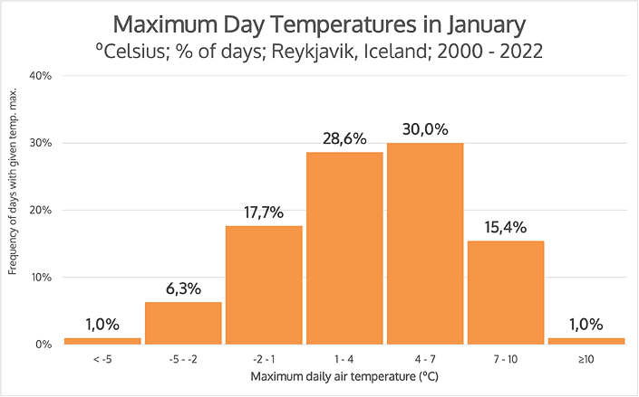
Distribution of daily temperatures in January
(% of days with a given max. daily temp., Reykjavik, 2000-2022)
Typical daytime temperatures for January range between 1 °C (34°F) and 7 °C (45°F) (that’s almost 60% of the days), and on only about 2% of days does the temperature drop below -5 °C (23°F) or rise above 10 °C (50°F). However, it should be remembered that at night the temperature near the ground sometimes drops as low as -20 °C (-4°F).
Average temperatures in Iceland are rather mild, but extreme conditions can be truly extreme. Therefore, in January, expect a mild winter, but be prepared for a harsh one, too.
Weather in Iceland in February
February is still a winter month, of course, but especially in the south you can already feel spring slowly approaching. Frost is still standard at night, but on average it is already fairly mild – between 0 °C (32°F) and -3 °C (27°F). There are, of course, nighttime frosts of around -10 °C (14°F), but the warmest nights on record have been above 7 °C (45°F) – yes: above +7 °C in February, at night!
During the day, as in January, about 60% of days have maximum temperatures between 1 °C (34°F) and 7 °C (45°F), but almost 20% of days have temperatures between 7 °C (45°F) and 10 °C (50°F), and fewer than 5% fall below -2 °C (28°F). In the chart below, you can also see that the days in February split almost perfectly in half between those that record temperatures above and below 4 °C (39°F).
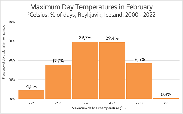
Distribution of daily temperatures in February
(% of days with a given max. daily temp., Reykjavik, 2000-2022)
Although daytime temperatures are usually above freezing, frequent nighttime frosts mean that snow lies undisturbed over most of Iceland.
In February, precipitation and wind remain high in Iceland. In the West Fjords it is the windiest month of all on average. In Reykjavik, too, February records the strongest gusts – averaging 33.4 km/h (20.8 mph). So even though the temperature may objectively be quite bearable, the “feels-like” temperature is still annoyingly low, and the risk of a critical break in the weather is high.
based on 2000-2022 data from Veðurstofa Íslands, vedur.is
Weather in Iceland in March
March in Iceland still has to be considered a winter month. However, the noticeably longer day creates weather that is much milder than in December or January and perhaps optimal for seeing the winter face of Iceland.
If you want to see the aurora borealis and remarkable ice caves, then March is the perfect time for it.
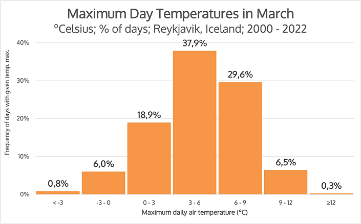
Distribution of daily temperatures in March
(% of days with a given max. daily temp., Reykjavik, 2000-2022)
The average maximum daytime air temperature in March is already almost 5 °C (41°F) – 4.7 °C (40.5°F) in Reykjavik, 4.0 °C (39.2°F) in Akureyri. Days with temperatures over 10 °C (50°F) are also becoming more frequent, and this is true both in the south and north of the island. However, nights are still cold (average: -2.9 °C / 26.8°F, extreme: -16.7 °C / 1.9°F), so you can still see snow in most of Iceland in March.
The wind has not yet begun to abate either. Its average speed in both Reykjavik and Isafjordur in the West Fjords is 16.7 km/h (10.4 mph). And the February record, measured at the Þverfjall station above Isafjordur, is still over 200 km/h (125 mph). So it’s getting brighter and warmer, but still conditions can be very difficult.
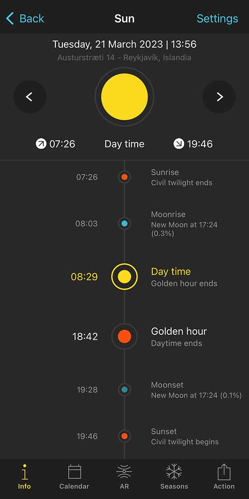
Amount of sunshine in March.
In all regions, monthly precipitation also remains high. Only in the north – in Akureyri – is it noticeably lower in March (as throughout the first quarter) than in the last months of the year. However, even there, total precipitation in March (47.7 mm) is almost exactly twice as high as in the following month – April (25.0 mm).
On March 21 comes the vernal equinox, the symbolic first day of spring. The sun rises at 7:26 a.m. and sets more than 12 hours later, as late as 7:46 p.m. Moreover, “daytime”, the time when the sun is at least 6° above the horizon, lasts for more than 10 hours (from 8:29 a.m. to 6:42 p.m.), while in December and January “daytime” does not occur at all. With cloudless skies, the weather can be ab-so-lutely beautiful!
In Iceland, March is certainly the last month of relatively stable – if harsh – winter weather. From April onwards, dynamic changes start shifting Icelandic weather into summer mode.
Weather in Iceland in spring
From the point of view of a tourist coming to Iceland, April and May should be considered spring here. These are two months of marked change between relatively stable winter weather and another relatively stable summer period. In April and May, by contrast, every weather factor changes very dynamically.
The spring changes are mainly an ever-increasing day length, rapidly falling precipitation, dropping wind speed and rising temperatures – both by day and by night. So all factors are changing in a way that is favorable to tourists.
However, let’s not get carried away. In the West Fjords, for example, the noticeably weaker wind amounts to this: while from November to March we record winds of up to 200 km/h (125 mph), the spring records only reach a “measly” 160 km/h (99 mph). Spring is still a challenging season.
April is still rather too cold and wet for a pleasant visit to the island – the chance of snow and/or a strong storm is still too high. But in May, tourist traffic clearly begins to increase, and prices usually still remain at or near winter levels. If you’re not afraid of bad weather and/or if you’re lucky, it’s possible to see Iceland very nicely by then.
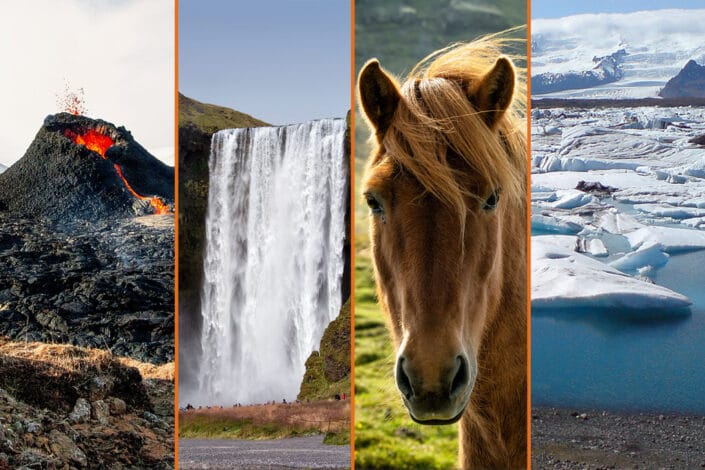
Travel plan: 7 to 13 days in Iceland in spring
If you’re considering a spring trip to Iceland, be sure to read our guide to a suggested spring itinerary (with places to see, where to stay cheaply and plenty of other tips): Iceland spring itinerary: 7 to 13 days.
Weather in Iceland in April
As we mentioned above, April is noticeably warmer than March, but nevertheless it is still a cool month. On the other hand, virtually all months are cool in Iceland, so there is nothing to be picky about 🙂
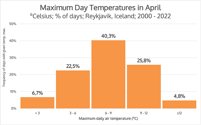
Distribution of daily temperatures in April
(% of days with a given max. daily temp., Reykjavik, 2000-2022)
As you can see, more than 40% of days have temperatures between 6 °C (43°F) and 9 °C (48°F), and as many as 88.7% have daily temperatures between 3 °C (37°F) and 12 °C (54°F). So it’s clearly warmer than in March, but it’s hard to say it’s warm…
Even in the north – in Akureyri – the average minimum night air temperature is already above zero in April (0.2 °C / 32.4°F, but still). And only in the West Fjords – in Isafjordur – does the average night temperature still sit below zero. Even there, though, it is barely below: exactly -0.8 °C (30.6°F).
Cold records in the West Fjords are still at winter values (-13.5 °C / 7.7°F), but the average maximum daytime temperature has already climbed clearly above winter levels: 5.2 °C (41.4°F).
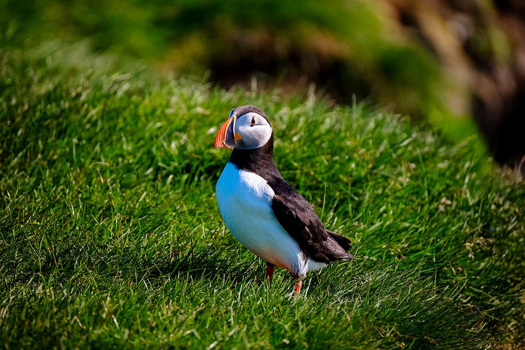
Puffin
In April puffins return to Iceland. These charming birds are the country’s icon and one of its top tourist attractions. They arrive on the mainland to nest and feed their young. Although they will not appear “in full strength” until May, you can already see them in many places in the second half of April. Cuteness overload 🙂
In all regions of Iceland, precipitation also drops noticeably in April. In the south, the decrease is still relatively small, but in the north – in Akureyri – April is the first of the three months with the lowest precipitation of the entire year.
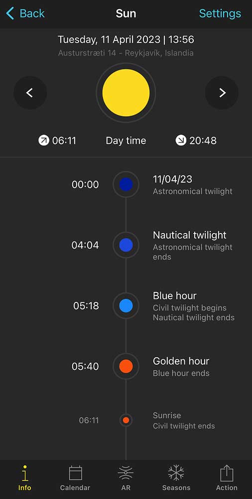
In April, the so-called “astronomical night” disappears
The length of the day increases so rapidly that already on April 11 the astronomical night disappears. This means that from that day onward the sun never drops more than 18° below the horizon, even for a moment. From midnight until about 4 a.m., there is the so-called astronomical twilight (the sun is between 12° and 18° below the horizon), but the astronomical dark night will not reappear until September 3…
Wind speed is also dropping. Interestingly, it falls noticeably more sharply in the north and in the West Fjords than in the Reykjavik area. In February the average wind speed is 17.4 km/h (10.8 mph) in both Reykjavik and Isafjordur; by April it is 15.8 km/h (9.8 mph) in Reykjavik and 13.8 km/h (8.6 mph) in Isafjordur. The numerical values may not be spectacular, but for Isafjordur that means a drop in average wind speed of just over 20%. This is certainly a noticeable change.
Weather in Iceland in May
If you want to see Iceland in relatively pleasant weather, before the crowds arrive and while car rental and accommodation prices are still reasonably low, May is the perfect month (see Spring trip plan for Iceland: 7 to 13 days).
The average maximum daytime air temperature is already over 10 °C in May (10.3 °C / 50.5°F), and fewer than a fifth of days (17.5%) have a maximum daytime temperature below 8 °C (46°F). This can be seen in the graph below.
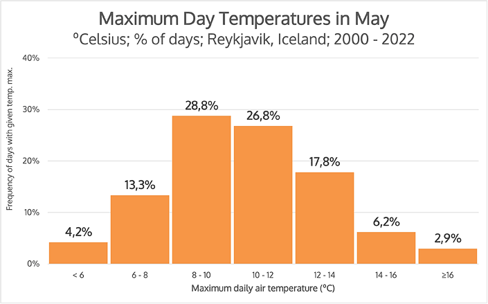
Distribution of daily temperatures in May
(% of days with a given max. daily temp., Reykjavik, 2000-2022)
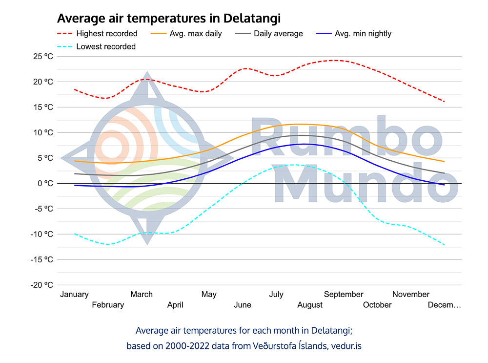
The above graph – like all on this page – shows data for Reykjavik, but in other regions the situation is very similar. In the north (Akureyri), the average maximum temperature is virtually the same. In the West Fjords (Isafjordur) it is 2 °C (4°F) lower, and only the east (the Dalatangi station) is clearly cooler, with an average maximum daytime temperature in May of just 6.6 °C (43.9°F) – almost 4 °C (7°F) colder.
The average minimum temperature at night in the south is 4 °C (39°F), in the north 3 °C (37°F), in the east 2.3 °C (36.1°F), and by this measure the coldest place is the West Fjords: 1.8 °C (35.2°F).
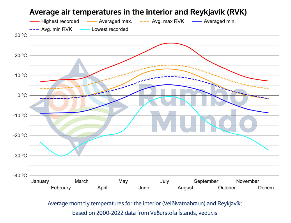
It is colder still in the interior – an average of 5.7 °C (42.3°F) by day and -1.3 °C (29.7°F) at night – but the interior is still closed to tourists in May, so we mention it only as a curiosity.
You can read more about the weather in different regions of Iceland in a separate article: Weather in different regions of Iceland.
In short, going purely by daytime air temperatures, May in Iceland already feels like a pretty nice early-spring month. And this is somewhat true, but with two caveats.
- First: although the wind is already noticeably weaker than in winter, the so-called “wind chill” is always strong in Iceland – even when it is weaker than in winter; if you find a place sheltered from the wind, it can be very nice and pleasant there; but most places in Iceland are not sheltered and the weather impression is quite cold;
- Second: unfortunately, the weather can break down at any time of year. A storm that comes from the north and brings Arctic air can “wind the weather back” to full winter for a few days. Most days will not be like that – but some certainly can be.
Let us reiterate an earlier caveat: the average temperature in May is 10.3 °C (50.5°F), more than 80% of days have temperatures above 8 °C (46°F), and the warmest days of May even exceed 18 °C (64°F). But when the weather breaks, it can be (for several days) much colder! The coldest days in May do not exceed 2 °C (36°F) during the day, and at night the temperature at ground level can drop even below -10 °C (14°F). Standard, typical weather is one thing, but if you are out of luck, the weather can be worse than in January…
Precipitation in May in virtually all regions of Iceland is at its lowest annual level. However, for some regions it is still high. For example, the station in Dalatangi in the east records an average of 112.4 mm of rain in May, which is in fact one of the lowest figures for that station. But at the same time, it is more than the weather stations in Reykjavik or the West Fjords record in any month of the year… That’s the East for you…
Compared with winter, the wind in May is already much weaker in every region. It is still easing, though, and will not reach its minimum until late summer.
Camping weather in Iceland in May
May under a tent in Iceland is still very challenging. It can be nice and warm during the day, but it can be close to winter too, especially at night. Be very well prepared if you choose to go for this.
Many people ask and wonder if it’s a good idea to go to Iceland in May and sleep in a tent. It’s cheaper that way, of course, and most campsites are already open in May. In addition, in most of Europe May is already very warm, and as you can see from the chart above, Iceland is also “survivable”. If you want to sleep in a tent, however, be prepared for a different kind of weather.
For those thinking about Iceland in May with a tent, we have collected data and prepared a graph showing the minimum temperature at night, at the ground level – see the blue graph below.
Air temperature is measured 1 m above the ground the world over – that is the standard we are all used to. But the temperature at ground level can differ from this quite significantly. And indeed – night temperatures near the ground in May in Iceland look quite different than the maximum daily temperature chart might suggest. See for yourself:
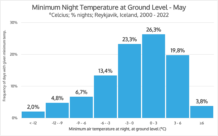
Distribution of minimum air temperature at ground level in May
(% of nights with given min. temp., Reykjavik, 2000-2022)
What do we see in the graph above? Well, among other things, that only half of the nights pass with temperatures above zero (to be precise, even the “lesser half” – 49.9% 😉 ). Half of the nights bring a ground frost, and one in seven (13.5%) a frost of -6 °C (21°F) or harder. The temperatures can even go below -12 °C (10°F)!
It is significantly more likely (13.5% vs 3.8%) that the air temperature at ground level will drop below -6 °C (21°F) at night than that it will stay above 6 °C (43°F). So as stated before – go camping only if you’re well equipped and know what you’re doing.
For the sake of completeness: the average minimum temperature at night (measured in the standard way, i.e. 1 m above the ground) is 4 °C (39°F) in May, with the highest recorded at 11 °C (52°F) and the lowest at -5.9 °C (21.4°F). So the readings are higher, but still rather low.
In May we still recommend accommodation in hotels, hostels or guesthouses. Sleeping in a campervan with a night heater is certainly comfortable, but it will not necessarily be cheaper. In a van with a roof tent, expect to spend the night in the cold. And it really is still far too early to pitch a tent on the ground.
May in Iceland already offers plenty of sunshine and often really nice, warm temperatures. However, the wind can still be annoying (or dangerous, even) and the nights very cold. This is the beginning of the tourist season, but not yet the beginning of summer…
Summer weather in Iceland
Summer (the period from June to August) is certainly the best time to visit Iceland. Admittedly, there are the most tourists here then, so the prices are also the highest, but the weather is by far the most pleasant, and on top of that, it’s the only period when you can visit the extraordinary interior (see, for example: Most Interesting Places of the Icelandic Interior [Top10]).
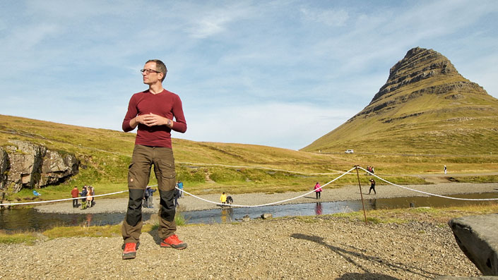
A warm August day in Snaefellsnes
The main features of summer weather in Iceland are the weakest wind, the lowest rainfall totals, the longest days and most hours of sunshine and, naturally, the highest temperatures.
Of course, one must make allowances for the fact that this is Iceland after all. So, for example, a distinguishing feature of the high summer temperatures is that only in these three months did the minimum night air temperature never (between 2000 and 2022) fall below 0 °C (32°F). The cold record for June was just 0.0 °C (32°F), for August 2.7 °C (36.9°F), and for July 3.4 °C (38.1°F). This is what “warm” means in Iceland 😀 .
For the sake of balance: the three summer months are also the only months in which the maximum daytime temperature above 20 °C (68°F) was recorded at least once (between 2000 and 2022). The warmth record (for the time being, as climate warming continues) was set on July 30, 2008: it is 25.7 °C (78.3°F). However, the average maximum daily temperature exceeds the 15 °C (59°F) mark only in July, and really by a hair’s breadth: it is exactly 15.1 °C (59.2°F).
Compared with the weather in central Europe, Icelandic summer is more like a kind of late, warm spring than an actual summer. Even in the warmest month – July – the average maximum temperature is only 15.1 °C (59.2°F), and the average minimum temperature is only 9.3 °C (48.7°F). In addition, there is still quite a strong wind.
To wrap up the subject of summer temperatures:
- Average maximum daytime temperatures range from 13.4 °C (56.1°F) in June, through 14.5 °C (58.1°F) in August, to 15.1 °C (59.2°F) in July.
- The highest temperatures on record exceed 20 °C (68°F): 22.4 °C (72.3°F) in June, 24.8 °C (76.6°F) in August and 25.7 °C (78.3°F) in July.
- The average minimum night temperature even in summer does not exceed 10 °C (50°F). That’s exactly 7.5 °C (45.5°F) in June, 8.8 °C (47.8°F) in August and 9.3 °C (48.7°F) in July.
- Summer is the only three-month stretch when Iceland (in the south and around Reykjavik) records no frost at all – though it comes close. The lowest temperatures recorded between 2000 and 2022 are: 0.0 °C (32°F) in June, 2.7 °C (36.9°F) in August and 3.4 °C (38.1°F) in July.
- However, even in summer there are so-called “ground frosts”. The distinguishing feature of the summer months in this regard is that (unlike any other month!) summer frosts do not fall below -10 °C (14°F). The lowest recorded temperatures at ground level are respectively: -8.4 °C (16.9°F) in June, -4.6 °C (23.7°F) in August and -4.1 °C (24.6°F) in July.
- The interior is noticeably cooler than the figures given above, as it lies almost entirely above 500 meters above sea level. A separate section of the article Weather in different regions of Iceland is devoted to it.
Summer is also the period of lowest rainfall (45 mm to 60 mm). In the north it is even less (just under 20 mm in July), while in the east, by contrast, the driest month is June, at 88.6 mm. Just a reminder that this figure – although a record low for eastern Iceland – is still higher than almost every month in Reykjavik…
In summer we can also count on the weakest wind (even “only” 10.9 km/h (6.8 mph) on average for the whole month). But again – in the particularly windy West Fjords, the lowest monthly average is almost twice as high: 18.7 km/h (11.6 mph; in the hills above Isafjordur). At the same time, the aforementioned Þverfjall hill never (between 2000 and 2022) recorded a month without winds exceeding 60 km/h (37 mph)! (and to be exact: 59.8 km/h / 37.2 mph).
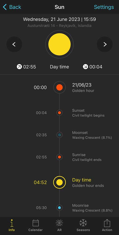
Golden hour all night
Summer is also the time of “white nights”. June, of course, reigns supreme in this statistic. At the summer solstice – June 21 – there is not only no night, but not even true darkness. The sun partially hides behind the horizon a moment after midnight, but is back above it before 3 a.m. All this time there is the so-called golden hour, that is, the period when the sun does not go more than 4° below the horizon. In practice you can see at least a sliver of it the whole time, and a pair of “blinkers” really comes in handy – a comfortable sleep mask that lets you sleep even when it is light outside.
Perhaps surprisingly, summer, quite like winter, is a period of relatively stable weather in Iceland (statistically speaking). The individual months do not vary that much, though June is certainly the coolest, and August can already be rainier. Since this is the most touristy, popular time of year, let’s take a separate look at the weather in each of the summer months.
Anyone particularly interested in, say, the weather in the West Fjords or the interior should again see the separate article on the weather in each region: Weather in different regions of Iceland.
Weather in Iceland in June
June is the first month with an average daily temperature exceeding 10 °C (50°F). Recall that for a month to count as summer, its average daily temperature has to exceed 15 °C (59°F). Iceland’s June – and July and August too – therefore falls quite a long way short of that…
Nevertheless, in Iceland, June is summer, because the average maximum daytime temperature is “as high as” 13.4 °C (56.1°F), and almost the entire month (93.8% of days) reaches a maximum daytime temperature of 10 °C (50°F) or more. See graph:
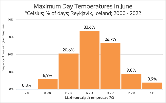
Distribution of daily temperatures in June
(% of days with a given max. daily temp., Reykjavik, 2000-2022)
The average maximum temperature of June is 13.4 °C (56.1°F) and indeed the temperatures of the entire month “oscillate” around this value. As many as 80.9% of days reach a similar temperature – between 10 °C and 16 °C (50°F and 61°F).
Even in the interior, the average maximum daytime temperature exceeds 10 °C (50°F) in June, as it is 11.2 °C (52.2°F). This is also the first month of the year when the average minimum temperature (at night) there exceeds zero: it is exactly 3.2 °C (37.8°F). Summer in full swing! 😉
June – like all summer – is also the period of lowest rainfall. Everywhere except the interior, it is the month with the lowest rainfall, although this means something “slightly” different for each region. The record-low rainfall is 18.1 mm in the West Fjords, 19.8 mm in the north (Akureyri), and 45.7 mm in the south and around Reykjavik.
In the east (the Dalatangi station), by contrast, the least rainy month still records 88.6 mm. It may be worth adding that in that region it is the only month with an average rainfall of less than 100 mm, while the other regions mentioned never exceed this limit…
June is also already a month of relatively weak wind. In most regions it will be a little weaker again in July, but even now it is weaker everywhere than in May, and 30-40% weaker than in the record winter months.
However, let’s remember the right scale. In the West Fjords, for example, June is not only the month with weak average winds, but also the month with the lowest wind speed record. This record for June is exactly 129.6 km/h (80.5 mph). That is almost half the January record (236.2 km/h / 146.8 mph), but a “low-wind” month in which we can be almost certain the wind will not top 130 km/h (80 mph) does rather curb one’s optimism…
based on 2000-2022 data from Veðurstofa Íslands, vedur.is
Weather in Iceland in July
Looking only at the weather, July is certainly the best month to visit Iceland. Virtually every region then has the lowest (or at least very low) rainfall, the weakest wind, a very long day, and, well, the highest temperatures.
As we mentioned earlier: the average maximum air temperature in July is a record 15.1 °C (59.2°F). And a little more than a third of the days actually pass at a very similar temperature, with more than 80% between 12 °C (54°F) and 18 °C (64°F). So by most European standards it is a “moderately warm spring”, but Icelanders already turn their air conditioning on 😉
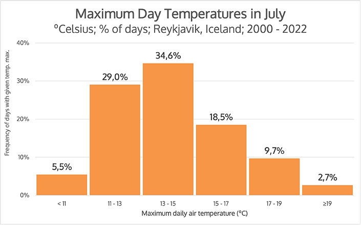
Distribution of daily temperatures in July
(% of days with a given max. daily temp., Reykjavik, 2000-2022)
The record high recorded temperature in July was the aforementioned 25.7 °C (78.3°F), but in general, temperatures above 20 °C (68°F) are rare – on average on less than 3% of days, so (statistically) less than once a month.
Other regions of Iceland record quite similar temperatures, mostly 1 – 2 °C (2 – 4°F) lower. Surprisingly, the record-holder in this unenviable respect is not the interior – where the average daytime temperature in July is 13.2 °C (55.8°F) – but the east! The weather station in Dalatangi in July records average maximum air temperatures of only 11.3 °C (52.3°F)! Detailed weather information for each region is in a separate article: Weather in different regions of Iceland.
July – like all summer – offers relatively low rainfall. Only in the north – in Akureyri – is it noticeably more than in earlier months, and in the east even more than in February (but the east in general is the rainiest).
In virtually all regions, it is also in July that we record the lowest average wind speed. In the north it is 10.8 km/h (6.7 mph), around Reykjavik 10.9 km/h (6.8 mph), in the east 16.9 km/h (10.5 mph), in the interior 18.3 km/h (11.4 mph), and in the West Fjords 18.7 km/h (11.6 mph). Stronger wind gusts can – and do – happen everywhere, but this is still certainly the calmest month in this regard.
Camping weather in Iceland in July
In July Iceland’s campsites are in full swing, and many people choose to sleep under a tent. This is very sensible, because in summer the costs of car rentals and accommodation are highest, and sleeping in a tent allows you to reduce them sharply.
However, when planning a tent overnight stay, there are three main challenges to keep in mind:
- Most campsites are simply grassy fields. They can be very waterlogged when it rains and soon after. You need to choose carefully where to pitch your tent, and to have shoes that don’t mind water.
- Nights are bright and windy. You really need a sleep mask in your tent, and many people also find earplugs useful. Campsites in the lowlands are (usually) reasonably sheltered from the wind, but in the interior it even happens that the wind simply tears up weaker or less well-pitched tents.
- Summer, Icelandic-style, is not very warm. In the interior it can snow at any time, and even outside the interior you have to expect really cold nights. More than three-quarters of the nights pass with a minimum temperature between 7 °C and 11 °C (45°F and 52°F), but temperatures near the ground drop much more: more than 90% of the nights “pass” below 9 °C (48°F), and almost 10% below 0 °C (32°F). See the chart below.
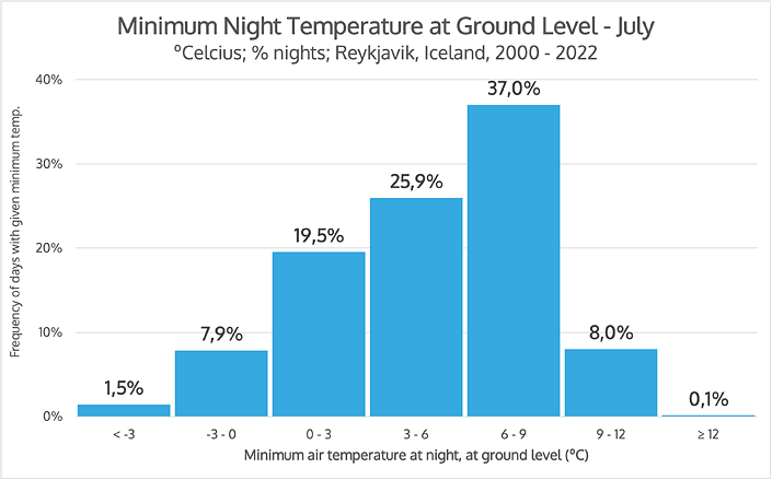
Distribution of minimum air temperature at ground level in July
(% of nights with given minimum temp., Reykjavik, 2000-2022)
As you can see above, although most often the temperature at ground level falls “only” to between 6 °C and 9 °C (43°F and 48°F), unfortunately almost 30% of nights record a ground temperature below 3 °C (37°F). This will be especially true for the interior, where you can absolutely expect snow and night frosts on any day of the year.
Keep in mind that this is data for Reykjavik, quite accurately representative of the entire southwestern region of Iceland. In other areas, as we wrote above, it is similar, but nevertheless usually about 1 °C to 2 °C (2 – 4°F) cooler, so those 30% of nights there may already record temperatures around 0 °C (32°F).
The minimum temperature, measured traditionally – i.e., 1 m above the ground – in July for all regions of Iceland averages between 7 °C and 9 °C (45°F and 48°F). But the temperature near the ground is noticeably lower, and it does occasionally drop below freezing even in July.
If you are going trekking in Iceland, July is the time to do it – but be sure to bring warm clothing, a sturdy tent and a gas stove that doesn’t mind the wind, ideally a JetBoil type.
Weather in Iceland in August
August is certainly a summer month in Iceland, but already with a distinct “stamp” of autumn. In some regions, it’s still very much a summer month, but in others, it’s already clearly more autumnal.
August is the last of the three months with an average daily temperature of more than 10 °C (50°F) (to be precise: 11.3 °C / 52.3°F). The average maximum daytime temperature then is 14.5 °C (58.1°F), and the average minimum at night: 8.8 °C (47.8°F). It is also the last of the three months when frost does not occur in Iceland (outside the interior, and not counting ground frosts, of course).
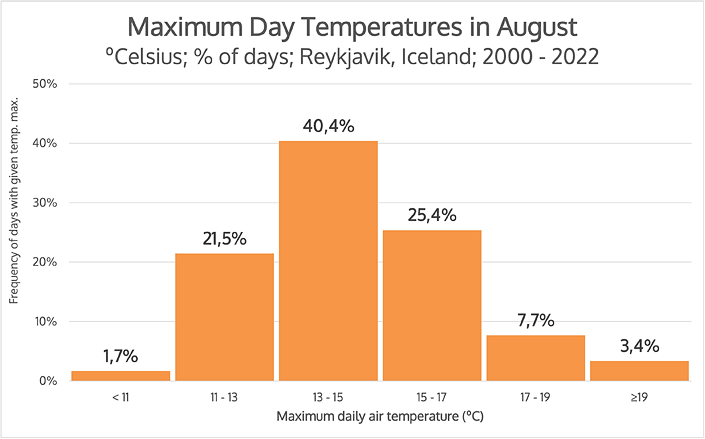
Distribution of daily temperatures in August
(% of days with a given max. daily temp., Reykjavik, 2000-2022)
As you can see on the chart, a little over 40% of days pass in Iceland in August with maximum temperatures between 13 °C and 15 °C (55°F and 59°F), with a huge majority – 87.3% – falling somewhere between 11 °C and 17 °C (52°F and 63°F). The lowest temperature recorded in recent years was 2.7 °C (36.9°F), and the highest: 24.8 °C (76.6°F). A little over a third of days (36.5%) bring a maximum temperature of 15 °C (59°F) or higher. As Icelandic months go, then, August certainly passes as a warm summer month.
The lowest average maximum daytime temperature is measured at the eastern station in Dalatangi (11.6 °C / 52.9°F), and not at stations in the interior (12.0 °C / 53.6°F) nor in the West Fjords (12.8 °C / 55°F). This is also a sign of summer, because August is the warmest month of the year in the east.
Of course, this is weather information for the lowlands and the “ordinary” interior. If you drive or hike higher – such as to the Askja crater – the weather can already be fully wintry.
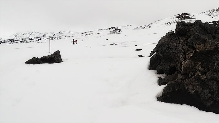
Path to Viti Crater (Askja, August 2019)
As for night temperatures, here the interior is back in first place – from the bottom, in a sense. In August, the lowest average minimum temperature at night was 4.4 °C (39.9°F) as measured at the Veidivatnahraun station in the interior. That is a clear few degrees lower than the same measurement in every other region, including in particular the Reykjavik area, where, as we mentioned above, it is 8.8 °C (47.8°F). The distribution of temperatures near the ground is very similar, almost identical to July’s, shown above.
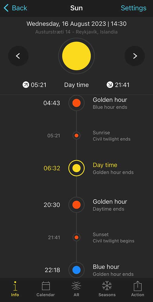
The hours of sunrise and sunset in August
August – like all summer actually – is also the period between the summer solstice and the autumn equinox. So the day becomes shorter and shorter, but nevertheless it is still long. In the middle of the month – August 16 – sunrise occurs at 5:21 a.m. and sunset at 9:41 p.m. “Daytime” – the period when the sun is more than 6° above the horizon – lasts from 6:32 a.m. to 8:30 p.m.
August is also the last month with low winds (although as far as these factors are concerned, regional differences begin to play a bit more of a role). The West Fjords even once had an August in which the wind speed did not once exceed 60 km/h (37 mph) on any day – something quite unheard of for the region. For comparison: there has never yet been a January there without gusts of more than 120 km/h (75 mph).
In the Icelandic interior, August is the month with the lowest precipitation (an average of 51.3 mm), but in all other regions it is already significantly higher than in May and June, although still far below winter and – the record-holder in this respect – autumn. For the Reykjavik area, it’s 61.2 mm, compared to 45.7 mm in June and 80 mm to 100 mm from September to March. In other regions, the pattern is similar, although the actual figures differ. In the east, the rainiest region of all, August already records 135.9 mm of rain, but there, too, that is far less than will fall in September or January, and above all in October, the record month there.
On the Icelandic lowlands, August is still summer, even if the nights are sometimes cool. But in the interior and in the mountains, the weather can already be quite wintry.
In the second half of August, puffins also begin to depart from Iceland. They will spend the winter off the mainland – feeding in the cold waters of the North Atlantic.
Autumn weather in Iceland
Autumn in Iceland sometimes begins as early as the end of August, and sometimes not until somewhere in mid-September. Temperatures (especially at night) fall, the wind blows ever stronger, and the rain comes more often and heavier. The days become not only colder but also wet, short and increasingly dark.
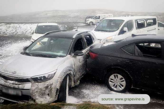
The storms are also already starting to get stronger. Although winter is considered the main storm season, the most recent notable storm – one that tore the roofs off houses, broke windows (including in cars) and moved cars across parking lots – happened in September. More specifically: September 25, 2022 in northeastern Iceland. See the article here: East Iceland Battered By Storms, Extensive Damage.
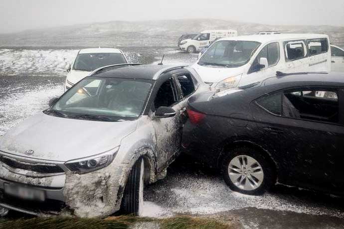
“East Iceland Battered By Storms, Extensive Damage”
(article in Reykjavik Grapevine)
Prices for many services also drop noticeably in autumn, but tourists are fewer and fewer anyway. The weather does nothing to encourage sightseeing – or visiting Iceland at all. Mountain roads (marked F) and most campsites are gradually closed. In the second half of September, the last of the puffins are also leaving Iceland. Many whales are also leaving the coastal waters. They swim further south, toward the Caribbean, to give birth and feed their young. Winter is coming…
It is worth noting that autumn, like spring, is – at least from a tourist’s point of view – a shorter season than winter or summer: it lasts only two months. August is still warm enough to belong to summer, while November is already cold and wet and snowy enough to count, realistically, as a winter month. Therefore, autumn is actually only September and October. Two months when Iceland returns from its relatively warm and welcoming state to winter weather that is as stable as it is unpleasant.
Autumn has temperatures and wind speeds similar to spring’s. The main difference between these seasons is the amount of precipitation. While it is relatively low in spring, it breaks records in all regions in autumn. For parts of Iceland, September is the rainiest, and for the rest, October. Naturally, in the east these rainfall records are about twice as high as anywhere else in the country.
Autumn is the worst time to visit Iceland. The weather is very unpleasant, with strong storms becoming more frequent. And at the same time, it is still too early for most of the typical winter attractions (aurora borealis, ice caves).
What is the weather like in Iceland in autumn? Here is a brief summary of it:
- Average maximum daytime air temperature ranges from about 6 °C (43°F) in the north and West Fjords, to about 11 °C (52°F) in the east and south. In the interior it drops to 3 °C (37°F), but the interior is off-limits to tourists by then.
- The average minimum night temperature in the interior already drops below 0 °C (32°F), but in the lowland parts of the country it ranges from about 1 °C (34°F) in the north and West Fjords to about 6 °C (43°F) in the south and east.
- Autumn – like any season – on individual days can deviate very strongly from the averages indicated above. The highest temperature recorded then is as high as 24.1 °C (75.4°F) (east – Dalatangi weather station), and the lowest: -10.9 °C (12.4°F) (north – Akureyri), with ground frosts as low as -14.6 °C (5.7°F), and even harder in the interior (-18.1 °C / -0.6°F).
- Autumn rainfall totals are the highest of the year, though they reach different values in different regions. For most regions it is about 75 mm to 100 mm, but in the east, the record-holder in this respect, it can be over 200 mm!
- The average wind speed in Iceland also rises very quickly in autumn, reaching at least 80% of its maximum in every region: from 10.6 km/h (6.6 mph; north, Akureyri) to 22.9 km/h (14.2 mph; interior).
- In early autumn, sunrise ends around 7:30 a.m., and sunset begins at around 7:30 p.m. At the end of autumn (late October), it’s around 10:30 a.m. and 4 p.m. respectively.
Weather in Iceland in September
Autumn in Iceland begins mainly with an increase in wind speed and rainfall.
Winds in the south and Reykjavik reach an average of about 14 km/h (8.7 mph), which is about 30% more than in the calmest month – July – although still about 20% less than the windiest month – February. In other regions, the pattern is very similar, although the average wind speed itself can vary somewhat.
Rainfall totals rise from a moderate 61.2 mm by more than 60%, to a record 98.9 mm. In the east, September precipitation totals are as high as 165.3 mm, although for that region this is not (yet) a record.
Maximum daily temperatures are clearly dropping, but still usually stay above 10 °C (50°F) – see chart.
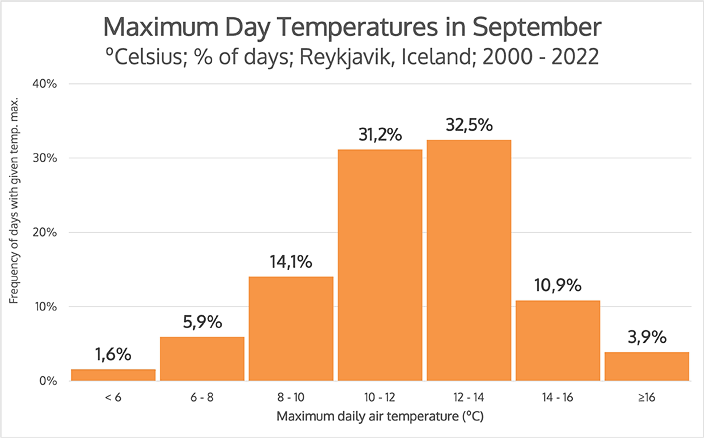
Distribution of daily temperatures in September
(% of days with a given max. daily temp., Reykjavik, 2000-2022)
More than 60% of days in September have a temperature close to 12 °C (54°F), and almost all (88.7%) are between 8 °C (46°F) and 16 °C (61°F). This is, of course, quite a wide range, but still does not include extremes. The highest air temperature measured in September reached 18.5 °C (65.3°F), but the coldest day did not even top 3.5 °C (38.3°F) – in September!
The average of the minimum night temperatures was 6.4 °C (43.5°F). The warmest September night reached 13.4 °C (56.1°F), while the coldest brought a clear frost: -3.4 °C (25.9°F). Minimum temperatures at ground level average 3.3 °C (37.9°F), but have already fallen as low as -10 °C (14°F). The record “frost” was as low as -11.9 °C (10.6°F).
September 23 marks the autumnal equinox. After that, the night is again longer than the day and its length increases quite rapidly in Iceland.
Weather in Iceland in October
October is another transitional month, after September, but still warm enough that it is hard to call it winter. Wind and precipitation are already at the high levels characteristic of winter, but the average maximum temperature during the day is still above 5 °C (41°F), and the night temperature is above 0 °C (32°F). So winter is still a little way off, although the weather really is far from “nice”.
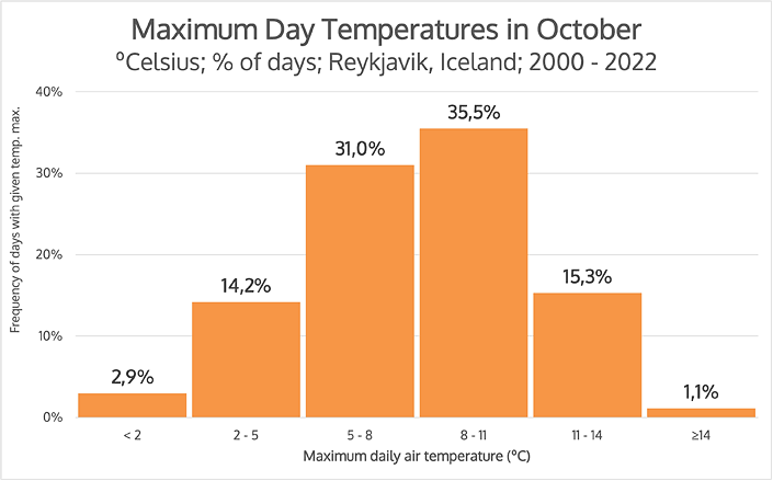
Distribution of daily temperatures in October
(% of days with a given max. daily temp., Reykjavik, 2000-2022)
The average maximum daytime temperature is 7.9 °C (46.2°F) in October. Nearly two-thirds of days (66.5%) pass with temperatures between 5 °C (41°F) and 11 °C (52°F).
Frost during the day (as a maximum temperature) is rather rare, but at night it is already the norm. Even the average minimum temperature at night already slips just below zero – it is -0.2 °C (31.6°F).
The maximum temperature recorded in October was 15.6 °C (60.1°F), but the lowest was -7.2 °C (19°F) – and at ground level -14.6 °C (5.7°F)!
In many regions, rainfall totals are slightly lower in October than in September (and lower than in winter), but in the rainiest eastern region, October is the rainiest month of the year. Between 2000 and 2022 the average October rainfall in the east was 208.8 mm (see the distinct “hill” on the right of the chart below). In many parts of Europe that is half a year’s worth of rain!
based on 2000-2022 data from Veðurstofa Íslands, vedur.is
The wind picks up in every region of Iceland too, but nowhere does it reach the levels of the winter months. For the oft-mentioned Þverfjall station in the hills above Isafjordur, the October wind speed (27.9 km/h / 17.3 mph) is almost 50% more than in July (18.7 km/h / 11.6 mph), but at the same time still almost 20% less than in January (34.1 km/h / 21.2 mph). So it is already really windy, but “we’re not there yet”.
Summary
So when is the best weather to visit Iceland? Strictly speaking, it will certainly be the summer holidays. However, if you don’t care about visiting the interior and want to avoid the highest prices, May and June will be the best.
On the other hand, for seeing the aurora borealis, ice caves and the beautiful winter landscape, February and March will certainly be the best, although you have to be lucky then not to hit one of the storms. And only autumn is the period that is actually best avoided.
In the article When (and how) it’s best to go to Iceland we write more about which time of year to choose for a trip to Iceland, how to arrange the whole trip, and in particular what to see, where to sleep, what car to rent and how to build your itinerary. You will also find links to suggested detailed itineraries, showing routes and places worth visiting for longer and shorter trips.
Sources
- Einarsson, Markús Á.: Climate of Iceland, in H. van Loon (editor): World Survey of Climatology: 15: Climates of the Oceans. Elsevier, Amsterdam, 1984, pp 673-697.
- Icelandic Met Office: Climatological data.