On
the Internet Thorsmork is often translated to ‘the Valley of Thor’. This translation is incorrect for at least two reasons.

Between the three glaciers Eyjafjallajökull, Mýrdalsjökull and Tindfjallajökull lies a place considered by many Icelanders to be the most beautiful corner on their island – Thorsmork (Þórsmörk). This beautiful and attractive place is extremely difficult to access, yet anyone can get here quite easily….
Thorsmork is located in the southern highlands of Iceland and is one of the country’s popular tourist destinations, often (especially by Icelanders) considered the most beautiful place on the island and a favorite of photographers and nature lovers.
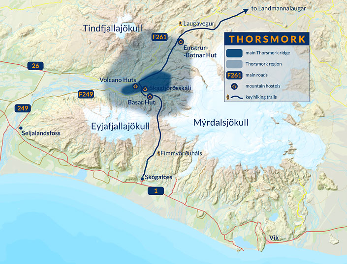
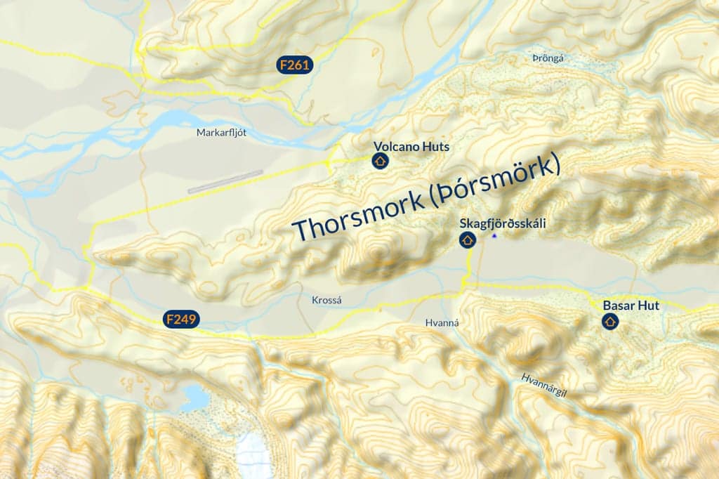
Thorsmork (Isl.: Þórsmörk) – map
© Based on data from National Land Survey of Iceland
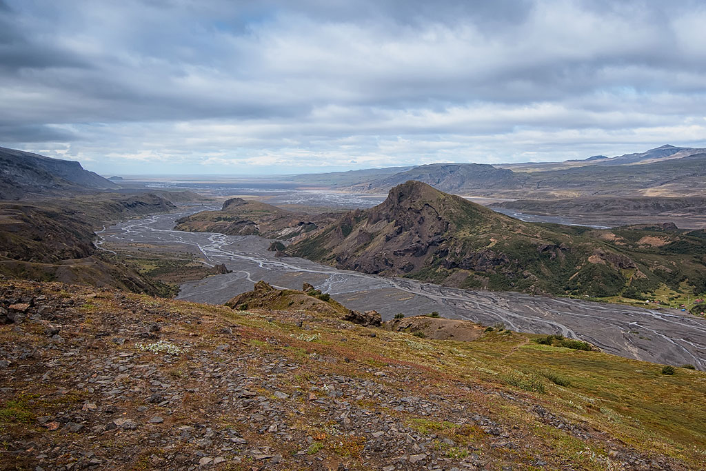
Strictly speaking, Thorsmork (Icelandic: Þórsmörk) is a mountain ridge located in a wedge between the Markarfljót and Krossa rivers. However, the name is most often used to describe the larger region adjacent to this ridge. The Thorsmork, so broadly defined, thus includes the valleys of these two rivers and the third Thronga (Isl.: Þröngá) to the north, as well as the mountains on the other side of these valleys. In total, then, it is quite a large area between the aforementioned Eyjafjallajökull, Mýrdalsjökull and Tindfjallajökull glaciers.
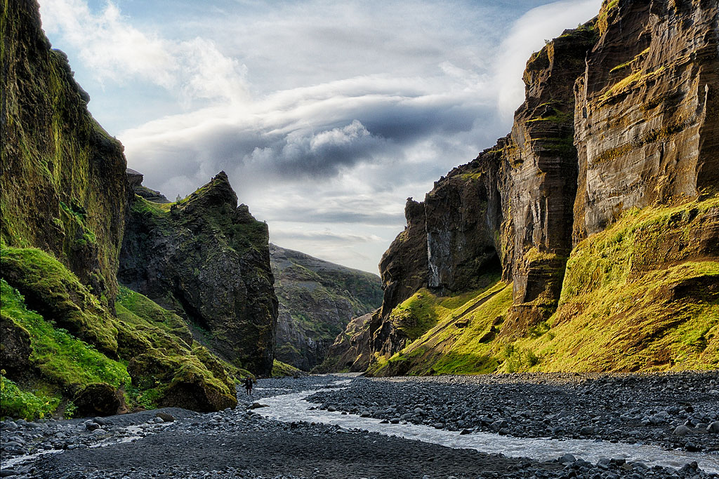
Þórsmörk is made up of hills, slopes and mountains crisscrossed by smaller valleys and ravines and covered with lush green vegetation. The region owes this vegetation to the fact that it lies – for Iceland – quite far to the south, while being sheltered on almost all sides from the hateful Icelandic wind. If Iceland is famous for its so-called “lunar landscapes,” Thorsmork is the inverse of that. Besides, that’s why Icelanders themselves are so fond of this valley – they lack such lush greenery in other parts of the country.
There are two, perhaps the most beautiful and popular long hiking trails on the island leading to Thorsmork: Fimmvorduhals (Fimmvörðuháls) and Laugavegur If you like hiking and can spare a few days to get away from civilization – it’s definitely worth it here.
The first one I pointed out earlier – Thorsmork is simply not a valley. “Main” Thorsmork is a mountain ridge, which is even the opposite of a valley. And if we want to look at it more broadly, we can say that it is a region, an area, a terrain, but not a valley. Anyway, in this broad view there are at least two valleys in Thorsmork – the Krossa and Markarfljót rivers. Which of them would be “this” valley of Thor? The third river – the Thronga – flows in a canyon rather than a valley, so it’s probably not that either.
The second and probably more important reason is that indeed, according to the rules of the Icelandic language, Thorsmörk can mean “mörk” belonging to Thor. Only, the word mörk does not mean a valley. In modern Icelandic, the word primarily means a wild, inaccessible area – wilderness. But in the past, its primary meaning was different: mörk meant forest!
To be sure of this we reached out to The Árni Magnússon Institute for Icelandic Studies, in Reykjavik. Here’s what professor Haukur Þorgeirsson, of the institute’s Department of Manuscripts, replied to us:
The meaning of the name Þórsmörk is obvious – it is “Thor’s Forest.” Another related “geographical” meaning of the word “mörk” is “wilderness, uninhabited area,” but it seems natural to take the meaning of “forest” in this case.
I dare not debate a professor at an institute specializing in Icelandic names, so Thor’s Forrest it is.
Admittedly, walking around Thorsmork, it’s hard to see a forest there (although you can easily call it a wilderness). Historically, however, Iceland was much more forested than it is today. One of the first settlers from the 12th century – Ari called Wise – described it in his work Íslendingabók as “forested from the mountain tops to the ocean coast”. Unfortunately, it was humans (albeit with the prominent help of volcanoes) that led to today’s situation, where trees are rare in Iceland and forests are virtually non-existent. Nevertheless, at the time of the first settlement, Thorsmork may have been covered with wild forest, so the name Thor’s Forest has a lot of justification, I think.
As a complete side note: “mörk” is also used as… a measure of infants’ weight and means 250 grams. In the old days it was a measure used quite commonly, probably the same as the elbow and foot used to measure length or stone meaning just over 6 kg. However, this is certainly not the meaning of the name Þórsmörk today.
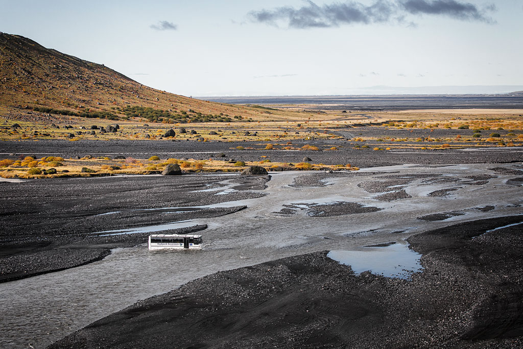
The Thorsmork Valley could become the most visited place in Iceland, if only it were more easily accessible. Unfortunately, the rivers flowing from under the 3 glaciers mean that at best when going there we have to ford some streams several times, and at worst the road leading there is closed and the valley is simply inaccessible. This happens on some days in summer as well.
One of Thorsmork’s distinguishing features, its special flavor, is crossing rivers at fords. And while the Markarfljót is simply too big to cross in this area, and the Thronga has too steep a slope, the third river, the Krossa, is a real challenge. It can be crossed, and suitably strong and tall cars (and buses!) do it quite often, but for ordinary off-road vehicles it is an interesting, though also risky crossing. It is a really dangerous, deep and wide ford on a fast and capricious glacial river. You have to cross it on the way to central Thorsmork, the Husadalur area and Thorsmork Skagfjordsskali, but if you don’t have a proper car and experience in such crossings – just give up.
detailed map of Thorsmork,
© Based on data from National Land Survey of Iceland
In winter (usually from mid-October to the end of April), the road to Þórsmörk is impassable and closed (it does happen in summer as well, but quite rarely).
Volcano Huts arranges transportation to the hostel for groups of more than 10 people at any time of the year.
You can always find the current status of the roads at https://www.road.is/
Several campgrounds and hostels offering different levels of accommodation are available in this beautiful region. All of them allow you to pitch a tent, and those that can be reached by car, of course, allow you (for a fee) to park an RV (although to get here it must be a 4×4 and a really off-road version). There will always be room for you at campgrounds, but if you want to sleep on a bed be sure to book as far in advance as possible. Hostels are rather small and usually fully booked even more than six months in advance.
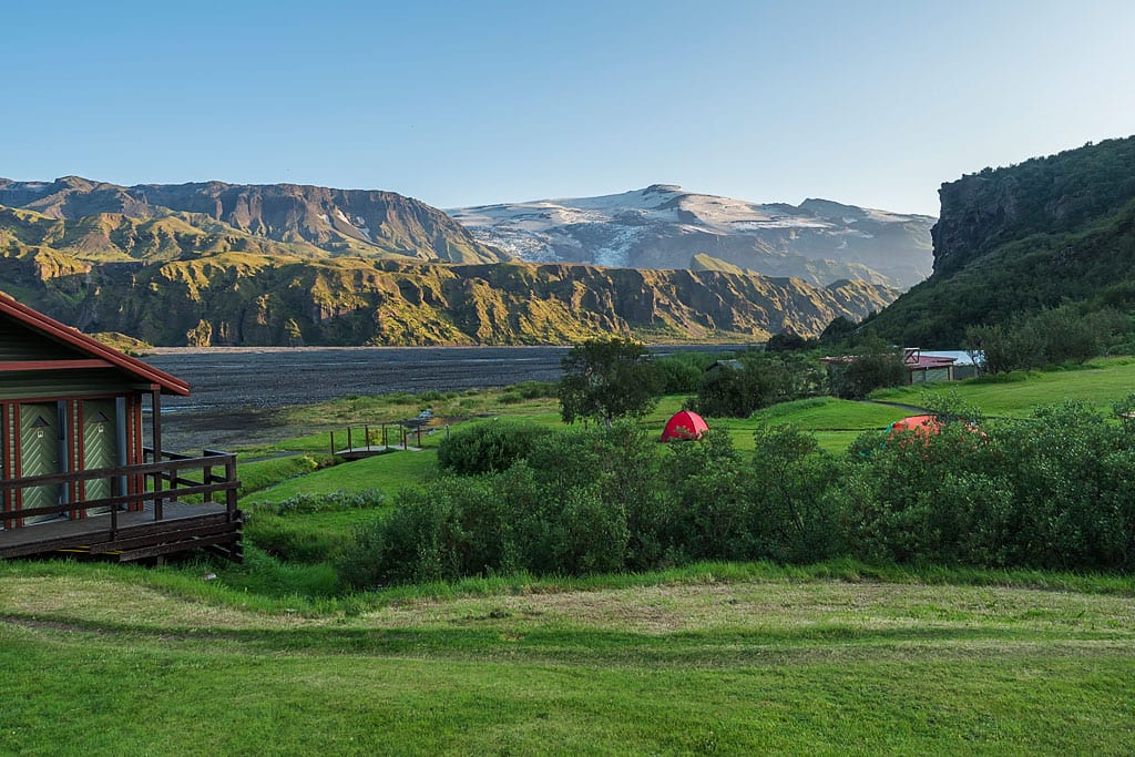
Camping at Skagfjordsskali hostel
The following hostels and campsites operate in the Thorsmork Valley:
The F249 road leads to Thorsmork. In its initial part it still functions not as a mountain road, but simply road 249. It departs from the ring road – road 1 – at the very popular Seljalandsfoss waterfall, about 130 km southeast of Reykjavik and about 60 km northwest of Vik and Myrdal.
The road from Seljalandsfoss to Basar Hut is only about 30 km, but usually a little over 1h drive.
The road to Husadalur/Volcano Huts bounces off the ‘main’ F249 to the north after about 25 km of driving, but the exact location of the Krossa crossing changes depending on water conditions – it’s already an off-road crossing par excellence, don’t go there if you’re not sure you can make it….
The price of the ride is 8000-9000 ISK (about $60) per adult. It may sound a bit expensive, but it’s a great way to get to the valley safely if you want to spend one or more days there walking on the surrounding trails, or if, for example, you want to cross Laugavegur and get to Landmannalaugar on foot (from where you will also return to Reykjavik by bus). Children under the age of 9 ride for free, and those aged 10-15 receive a 50% discount.
Alternatively you can join one of the guided tours from Reykjavik: