Inwinter crampons would certainly be useful on the upper trail, but in winter the vast majority of cars (including regular 4x4s) will not be able to reach the upper parking lot anyway, because the access road is not cleared of snow.
Reykjadalur is a beautiful valley with a hot mountain stream. It is located above the town of Hveragerdi (Hveragerði), about 50 km east of Reykjavik, in the southern part of the so-called Golden Circle.
Reykjadalur – an unusual hot stream
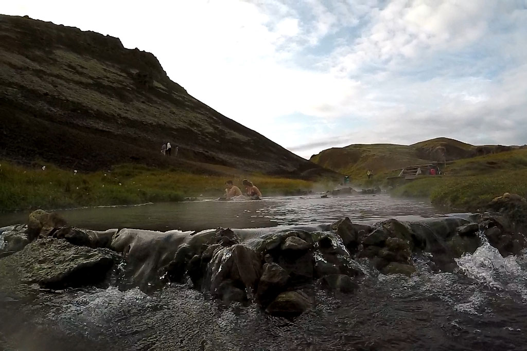
Full of hot springs and mud pools, the Reykjadalur valley is an ideal recreational area, famous for the hot stream that flows through its center and can be used all year round. It is certainly one of Iceland’s most extraordinary hot springs.

Upper Reykjadalur
Bathing in a hot stream “simply” flowing through a beautiful mountain valley is an absolutely unforgettable experience, especially if you know the sensation of bathing in the icy streams of the Rockies, Alps or Pyrenees. Reykjadalur is difficult to believe in, even when you already sit in it…


Reykjadalur hot spring — what you need to know
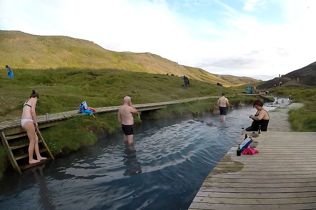
- The stream in the Reykjadalur valley, like most mountain streams, is very shallow; to immerse yourself completely, you have to lie down on the bottom in one of the deeper pools.
- On the stretch where the stream is usually in best temperatures, piers, wooden steps, and windbreaks have been built, making it a little easier to change and get into the water.
- Be sure to bring everything you need with you – a swimsuit, towel, a bag for your wet things, something to eat and drink – there are no shops at the top (there are some open periodically in the parking lot at the bottom); it is also worth being prepared for possible changes in the weather – there are no rain shelters in the valley.
- You might want to put your swimsuit on before you set off to the valley, if you’re OK with hiking in it. There’s no changing rooms “upstairs”. It’s also a good idea to take your water shoes with you, if you have them, as the rock in the stream are a bit difficult to walk on.
- There are two trails leading to the valley – one (more popular) from below and the other from above; both offer beautiful views; see below for how they differ and when and how you can use them.
- There are no fees for entering the valley or using the stream, but the lower parking lot is paid (in 2025 it was 1000 kroner for 5 hours; payments by Parka app, zone 8204).
- A trip to Reykjadalur is a wonderful experience at any time of year, as long as it is not raining; while it’s fine to enjoy the hot water in a light drizzle, remember that all your belongings will be covered only by whatever cover you bring with you.
- Do not stray from the designated trails – this is for both nature conservation and your safety near the hot springs.


It is also worth taking a walk to the geothermal region of Hverasvaedid (Hverasvæðið) in the center of town.
How to get to Reykjadalur? Two trails and a map
| Two routes to Reykjadalur – comparison | ||
|---|---|---|
| classic route – lower | alternative route – upper | |
| starting point | parking lot north of Hveragerdi, next to Reykjadalur Café 📍 Google Maps Pin |
small parking lot above the valley 📍Google Maps Pin |
| access road | asphalt, urban, for all cars | gravel, bumpy, not cleared of snow, 4×4 drive recommended even in summer |
| trail difficulty | minimal – gentle, wide trail | medium – trail slightly steep and sloping in places, with some loose gravel |
| walking time | approx. 60 minutes | approx. 20 minutes |
| number of tourists | high | minimal |
| parking | large, paid – ISK 1,000 (approx. $7) for up to 5 hours | tiny, near-wild, free of charge |
| Who is it best for? | For families, people who prefer walking, 2WD cars | For people prepared for mountain trails, 4×4 cars |

Map: access to the lower parking lot in Reykjadalur
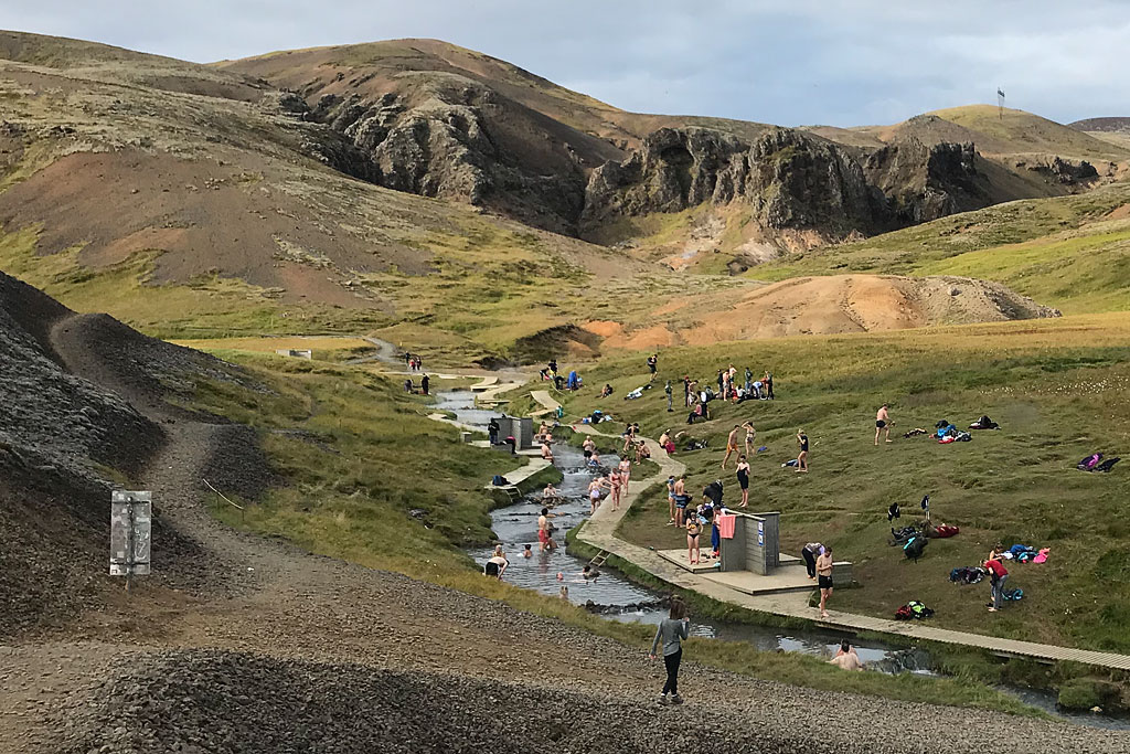
There are two routes to Reykjadalur – from below and from above. The lower route is accessible all year round, while the upper route is only accessible when there is no snow.

Map: access and hiking trails to the Reykjadalur hot stream
Option 1: Main trail from Hveragerði (year-round, paid)
View of the trailhead from the lower parking lot
Its main advantages are a fairly large (though paid) parking lot at the bottom and a relatively gentle, though quite long, walking route.
From this side, you can get to Reykjadalur all year round. From road No. 1 turn off to the town of Hveragerdi and drive to its northern end and a little further. In the final stage, follow the signs north.
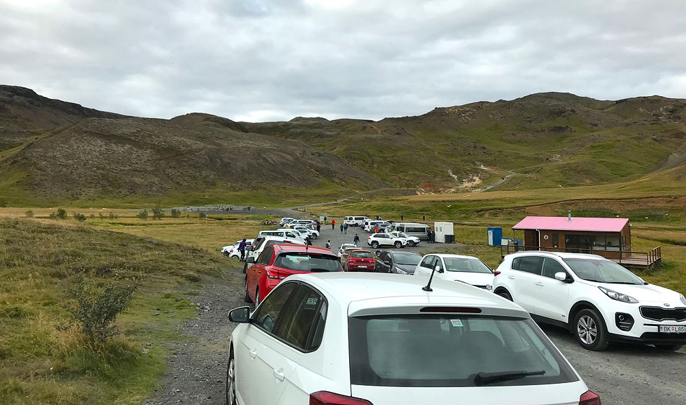
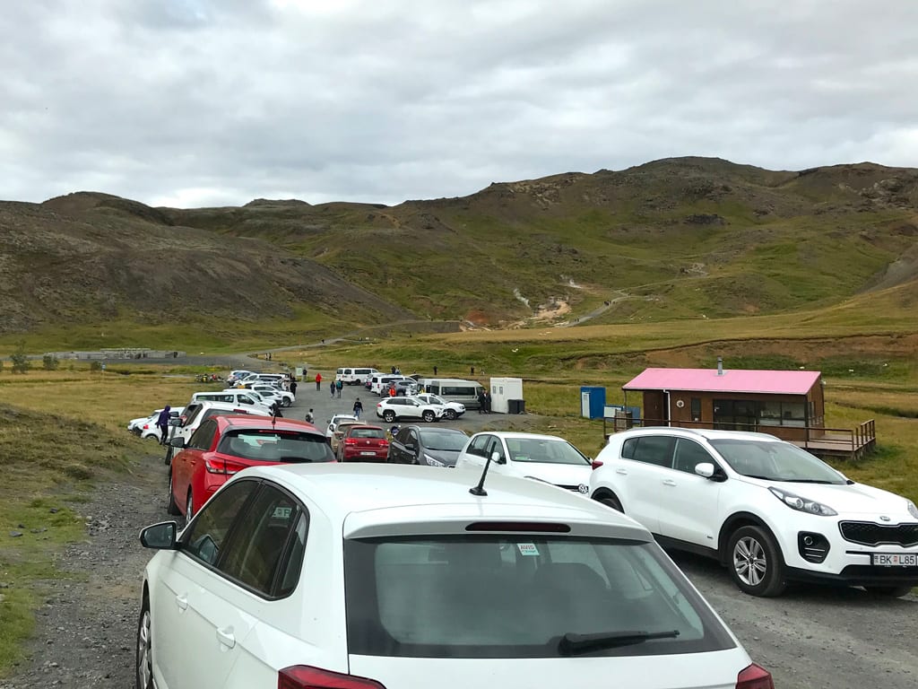
In summer, this lower parking lot can get quite busy and sometimes you have to leave your car a little earlier.
The trail to the valley starts at the parking lot and is clearly marked. The ascent takes about an hour, or about 45 minutes at a brisk pace, but there are no steep sections. The return trip takes about the same amount of time. The trail is well maintained and wide. In winter, it is a good idea to bring crampons, as parts of the trail can be slippery and icy.
Access to the trail, the valley, and the stream is free of charge. However, the parking is paid – currently ISK 1,000 (approx. $7) for up to 5 hours. Payment is made in the Parka app: zone 8204.
Option 2: Trail from the top of the valley (shorter, for 4×4)

View to Reykjadalur from the upper trail
To get to the upper Reykjadalur trail from Hveragerdi, you need to take road 1 towards Reykjavik and about 2 km after the switchbacks, turn right onto a small gravel road. When arriving from Reykjavik, there is no turn onto this road – you have to drive down to Hveragerdi, turn around on the first roundabout and climb the switchbacks on the north side of the road.
The access road is bumpy. In summer, any car can handle it, but I would advise against driving the smallest ones, the likes of Kia Picanto, on it. You risk damaging your undercarriage in the smallest cars and that certainly is not worth it. After about 5 km / 3 mi of picturesque driving, you reach a small parking lot on your right.
The upper parking lot is tiny. With a bit of luck, it can accommodate 10 vehicles, but no more. If there are no spaces left, you can drive about 1 km further to another parking lot, although the trail from there is obviously longer (but you don’t have to walk back to the first parking lot – find the trail leading directly from the second parking lot in the mapy.com app).
There is a clear path from the upper parking lot to the Reykjadalur valley. The upper and lower parts of the path are very comfortable and flat, but the middle part – the descent into the valley itself – is somewhat steep and with some loose gravel. So be careful there.
Inwinter crampons would certainly be useful on the upper trail, but in winter the vast majority of cars (including regular 4x4s) will not be able to reach the upper parking lot anyway, because the access road is not cleared of snow.
The trail to the valley is about 1.5 km / 1 mi long and takes about 20 minutes. The return uphill hike might take a little more – 30 to 40 minutes maximum.
Google Maps pins to key points on the upper route:
Which route to choose? Choose the best one for you
Both routes to the stream in the Reykjadalur valley have their advantages and benefits. The choice depends on your preferences, expectations, and, of course, the season in which you visit Iceland.
If you are traveling in winter, the upper road is almost certainly out of your reach. The access road to the upper parking lot is not cleared of snow, so driving on it when there is snow on the ground requires a high-clearance vehicle, preferably with special large wheels and tires. A regular 4×4 vehicle will not be able to handle it in winter. In winter, be sure to choose the lower trail and start from the parking lot in the northern part of Hveragerdi.
Also, if you are traveling around Iceland in a regular car or a large motorhome, there is no point in risking damage to the undercarriage (which is never covered by insurance!) and it is better to choose the lower route. There, you can reach the parking lot via a comfortable asphalt road, and your car, even if it is the smallest, will be safe. Admittedly, in favorable weather, you can drive to the upper parking lot with virtually any car, but it is not worth risking damage to your car.
Finally, choose the lower route if someone in your group has mobility issues.
If that person is able to walk on a slightly sloping gravel road, but a mountain trail would be risky for them, choose the lower route. The trail leading from the lower parking lot is much more comfortable, less steep, and better maintained. The trail leading from the upper parking lot is a lot steeper, more sloped, and with slippery, loose gravel. It’s an easy trail, as far the mountain trails go, but it is not a walking park path.
Ifnone of the above reservations apply to you and your group, then the upper trail is definitely better. The trail itself is shorter, less crowded, and offers even better views than the lower trail. And the parking is free, which is a rarity in Iceland nowadays.
During peak season, an additional disadvantage of the upper road is that the upper parking lot is really tiny (10 cars maximum). So in summer, there is a good chance that you will have to drive further to the next parking lot. From there, the trail down is a bit longer, but there is even less people on it 🙂
Fauna and flora of the Reykjadalur valley
The valley was formed by glacial erosion in the crater of an extinct volcano (the volcano was active about 120,000 years ago). It was therefore created by the two most important forces in Iceland.
The vegetation in these areas has been shaped by geothermal activity and includes lush wetland plant communities flourishing near hot streams and warm springs, as well as mossy areas in drier parts. This area is home to various thermophilic moss species (some endangered) and very rare colorful microorganisms.
Photos from Reykjadalur