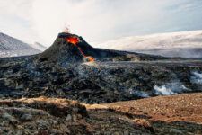
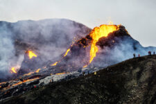
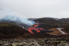
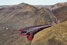
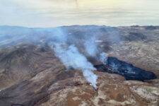
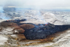
Seeing with one’s own eyes the lava freshly flowing from the volcano is such an extraordinary experience that not only for tourists, but for Icelanders themselves, the ongoing 2021 Geldingadalir/Fagradalsfjall eruption has become a huge tourist attraction.
On August 3, 2022, the eruption “revived” this time in the Meradalir valley, about 1.5 kilometers from the 2021 crater, but stopped already on August 21. Again, it is worth keeping in mind when planning a visit to Iceland.
Up-Date: New eruption: 2022 (Meradalir)
August’s volcanic eruption lasted from August 3 to 21, 2022. After the eruption stopped, a new hot lava field remained, which began to slowly cool. Geologists are quite unanimous in predicting that further eruptions are to be expected in the region, but they cannot give even an approximate date for such further episodes.
The period between eruptions
When lava flow ceased from the crater in September 2021, volcanologists agreed that this was probably not the end of eruptions, and certainly not the end of seismic and volcanic activity in the region. Eruptions such as Geldingadalir can last as long as 150 years, though usually with even fairly long breaks in between.
For the next six months, the peninsula remained active, but the date of the next eruption was difficult to predict. Rather, scientists cautiously spoke of the next few years – on a volcanic scale, that’s still very fast. However, in June and especially July 2022, earthquakes began to appear more and more, and satellite measurements unequivocally confirmed that the ground was rising, which meant that new lava was flowing into the volcano’s system and “pushing apart” the earlier fissure.
The peak wave of seismic activity began on July 30, 2022, when up to 10,000 (small) earthquakes per day were felt on the peninsula! For the most part, these quakes were small, below M3, and therefore virtually imperceptible to humans. However, the strength of these strongest tremors also gradually increased, and just on July 30 they began to exceed the M4 limit, and on July 31 at 5:48 p.m. even a tremor of M5.4 magnitude was recorded, which is already a strong event, even for Iceland.
This series of events strongly resembled what happened immediately before the March 2021 eruption, so many Icelandic enthusiasts thought that Gelidngadalir was coming back, but volcanologists also confirmed that (unless activity dies down), we could be facing a new eruption “in the near term.”
Meradalir eruption 2022
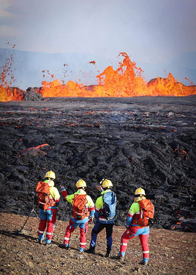
Meradalir eruption 2022. [source: safetravel.is]
The new eruption took place in the same region – about 1 km northeast of the previous one. The site lies in the Merardalir Valley, into which some of the lava from the 2021 eruption periodically flowed.
The new eruption was fissure-like in nature.
Unlike typical craters, here the lava came to the surface through a rather long fissure. Initially, the length of this fissure was up to 500 meters, but just a few days later it had shrunk to about 100 meters.
Due to the very short duration of the eruption, the volcano did not manage to form a new cone similar to the one in 2021.
E
ruption was more intense than the one in 2021. According to initial measurements, up to 50 m3 of lava per second came out of the fissure in the first few hours, which would mean an eruption up to 10 times larger than that of 2021. After a few days, the intensity of the outflow decreased, but even the level of 20-30 m3/s is still several times higher than that of 2021. Not surprisingly, the lava quite quickly occupied a large area and poured into the Meradalir Valley.
A large amount of gases also came out of the volcanic fissure, the chemical composition of which was being studied on an ongoing basis. However, no ash was emitted from it, so air traffic was not disrupted. Instead, an unusually large number of tourist helicopters flew in the area of the explosion – the demand for such sightseeing flights has again increased tremendously….
A new hiking trail to the site of the eruption has been marked out – it is a route of about 7 km, but due to the rather difficult mountainous terrain, it will take up to 5-6 hours of walking (both ways) to cross it. Periodically – in exceptionally bad weather or high gas emissions – the Civil Service not only advises against entering the trail, but even closes it.
Due to repeated incidents of serious exhaustion of families trying to see the volcano with their children, there is also a BAN on entry for children under 12.
It is necessary to prepare very well for such a trip and plan it flexibly.
Eruption end – 2022
Seismic tremors in the eruption region began to decrease noticeably from around August 18, and stopped completely on August 21, along with the end of lava emissions.
Fresh lava has ceased to appear in the region, but the lava already deposited there will continue to cool for many more months.
According to information from the Icelandic Meteorological Office, there are still various volcanic hazards in the eruption region, including, in particular, the emission of potentially poisonous gases, so the relevant services are monitoring the situation on an ongoing basis and can still close access to the eruption site if necessary.
It is impossible to say when the eruption will start again, but scientists agree that we can expect more episodes in this volcanic system. However, whether this will happen in the next weeks, months, years or maybe even decades – it is impossible to determine. Such eruptions can last as long as 150 years, but the gaps between episodes can also be years.
If
there is any new developments on this volcano, we will keep you informed by updating this article.
Top tourist attraction of 2021
The eruption in the Geldingadalir Valley, on the slopes of Fagradalsfjall (385 meters above sea level), began on Friday evening, March 19. Perhaps that’s why almost immediately after the eruption – and confirmation of its mild course – many people, taking advantage of the free weekend days, decided to see it up close and personal. Not only tourists, who, due to the COVID-19 outbreak, were few in number anyway, but also Icelanders themselves wanted to look at the freshest lava up close.
A spontaneous parking lot was set up on a nearby road, and many people had a picnic near the eruption. Some decided to play volleyball near the lava, others tried scrambled eggs fried on the lava. Numerous drones buzzed in the air – and were often destroyed from the heat. Until the Civil Service began to somewhat control and order the flow of people, the whole thing took on the character of a spontaneous and rather joyous celebration, where everyone wanted to enjoy a magnificent display of the force that is steadily creating and enlarging Iceland.
The eruption was dynamic, new points of lava flow appeared, and the gases coming out of the fissures changed their composition and were sometimes dangerous. The whole thing, however, was closely and continuously monitored by the Icelandic Civil Service, and whenever the situation could become dangerous for visitors, the entire area was closed off, and any people already there were evacuated.
C
urrently (as of September 2021) the eruption site is just a more or less smoky field of OVERLAPPED lava. You can’t see lava flowing or shooting into the sky at the site. The site is therefore no more interesting than, for example,
Berserkjahraun,
Surtshellir, or
Vidgelmir, and certainly much more difficult to access.
Several strong tremors (maximum M 4.8) were recorded in the area in mid-May 2022, so there is a strong possibility that another crater will open here soon. Until then, however, it’s only worth going here if you’ve already seen all the other attractions, and are looking for a theme for a few hours of trekking…
How to see the Geldingadalir eruption site
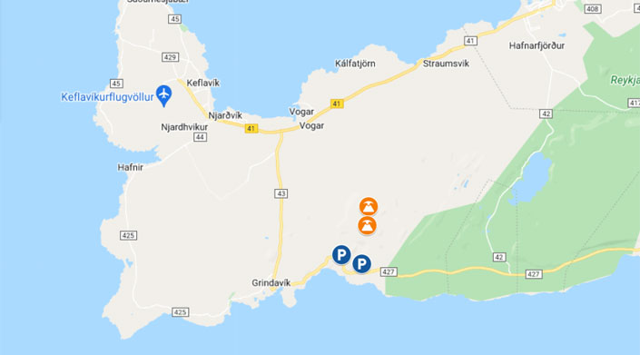
The lava flow points lie northeast of Grindavik and east and southeast of the summit of Fagradalsfjall.
Map: eruption sites and parking lots at Geldingadalir / Fagradarsfjall
The best access to the eruption site is from road 427 (Suðurstrandarvegur) east of Grindavik. Two hiking trails (marked A and B) have been marked from the nearest point to the eruption site itself. The trails are marked with special posts, but pretty soon hikers have trodden clear paths (or even roads) there, which are impossible to lose. Trail A runs along the southeastern border of the Geldingadalir Valley, and Trail B runs west of it, along the slopes of Fagradalsfjall. Each of the trails has a length of about 4 km, but they run through quite difficult terrain, making their crossing time up to about 2h one way. The choice of route depends on the direction of the wind – you should go as far to the windward side as possible to avoid possible harmful volcanic gases. There are also plans to build a road near the volcano.
EDIT: At the end of April 2021, the volcano formed new craters and accelerated its eruption, flooding the Meladalir Valley and much of designated Route B, among other things. In contrast, by early May 2021, most of the craters that had formed no longer participated in the eruption – they became inactive. On the other hand, the only crater that remained active is operating much more actively than before – including ejecting plumes of lava up to several hundred meters up and emitting a relatively large amount of dangerous gases. The situation is developing dynamically, but now (in May ’21) it is no longer possible to approach the volcano at such a short distance as in April. The Civil Service designates a safe observation zone of about 500 meters from the active crater. The views are still breathtaking….
In the area of the eruption, there is practically a constant presence of emergency workers and the Civil Service, who will direct us to the right path if necessary.
T
he hike alone is about 2 hours of walking each way, plus the time it takes to get from where you park your car to the beginning of the trail. If you want to spend some time at the lava itself it is actually a full-day excursion.
It is essential to adjust your attire for such a long trek, to protect yourself against possible (almost certain in Iceland) weather changes, and to bring enough provisions and water. It is also imperative to have a working cell phone, as local services will use it to possibly alert tourists and call for evacuation should the eruption become dangerous.
P
revious eruptions in the area (thousands of years ago) lasted between 100 and 300 years. Also, in other parts of the world and at other times, this type of eruption – a slow outflow of relatively rarefied lava – is usually just long-lasting. So there is a good chance that there is no need to rush to this volcano. We will probably be able to enjoy the Geldingadalir eruption for a very, very long time to come.
Course of the Geldingadalir eruption
The Reykjanes Peninsula has long been one of Iceland’s most seismically active regions. Volcanic systems in Iceland most often run along a northeast-southwest direction, and the same is true in Reykjanes. Therefore, there are as many as three volcanic systems on the peninsula: Brennisteinsfjöll (a.k.a. Bláfjöll), Krísuvík (a.k.a. Krýsuvík or Krýsuvík-Trölladyngja) and Reykjanes (along with Svartsengi). In addition, as it were, on the southwestern extension of the peninsula, but already underwater, there is another system – Eldey. In turn, on the northeastern border of the peninsula lie another three volcanic systems – Grímsnes, Hrómundartindur and Hengill. In total, that’s almost 20% of all Iceland’s volcanic systems….
Eruption announcements
In the Krysuvik system, the last eruption took place in the 12th century, and there were at least 10 in the entire Holocene (the last 8,000 years). As late as 2020, several earthquakes a week were recorded here. For the most part, these were quakes with a magnitude of less than 3, and thus de facto not felt by humans, but shocks with a magnitude of more than 3 were also quite frequent.
In 2021, the number and strength of these tremors increased markedly, which was a clear signal to all seismologists that magma was moving underground and coming closer and closer to the surface. By the end of February 2021, at least 90 tremors of magnitude M4 or greater had been recorded in the Fagradalsfjall area, and on February 24 two tremors of magnitude greater than M5. It was clear that if this process was not stopped for some reason, it would lead to an eruption in the short term.
Volcanic activity in the region of Mount Fagradalsfjall intensified again in mid-March 2021, with more than 1,700 tremors recorded there on March 11; a record of more than 3,000 on March 14; more than 1,000 on March 15; more than 1,400 on March 17; and about 400 seismic tremors on March 18. Most of these tremors had magnitudes below M3, but the strongest – on March 14 at 14:15 GMT – had a strength as high as M5.4.
Main eruption of Geldingadalir
After several weeks of tense anticipation, numerous cameras were set up in the Fagradalsfjall region, including those streaming live video to the Internet. Not surprisingly, perhaps for the first time in history, the eruption was recorded not only by seismic instruments and specialized satellites, but also by many Internet users watching the live camera feed.
On March 19, 2021, at around 20:45 UTC, a volcanic eruption began in the Geldingadalir valley, at the foot of Mount Fagradalsfjall.
The very next day, Icelandic scientists confirmed that the eruption was small and mild, as expected. The eruption fissure was about 500-700 meters long, the lava fountains were described as small, and the whole event was described as non-threatening to local residents. The main potential danger – volcanic gas emissions – was closely monitored. However, it turned out that it, too, could at most cause “discomfort” to those in the immediate vicinity of the eruption. Air traffic at the nearby Keflavik Airport was halted for only a few hours immediately after the initial eruption.
A
ccording to data from the end of March, the magma is rich in magnesium oxide (about 8.5%), indicating that it comes from a depth of about 17 to 20 km.
Next craters
About 2 weeks after the first eruption – on April 5, 2021 – two more craters appeared near the first fissure, and another one on April 6. In total, a large part of the Geldingadalir valley was already occupied by fresh lava, and lava from the third fissure also began to flow into the neighboring Meradalir valley northeast of Geldingadalir. In the following weeks, new fissures and lava flow points appear every few days.
Nothing predicts an increase in the intensity of the eruption, but more lava fissures are appearing in the region. According to scientists’ predictions, if the eruption continues in the same way (about 5-7 m3/s), a new shield volcano will form in place of the Geldingadalir valley. This is not a quick process – eruptions forming such volcanoes take up to several hundred years each. Also, previous eruptions in the Krysuvik system lasted from 100 to even 300 years. So we most likely have plenty of time to watch the formation of this volcano with our own eyes.
Change in nature of eruption
In late April and early May 2021, most of the craters that formed ceased activity. The lava in these craters began to cool, and the smallest craters slowly began to disappear under layers of new, fresh lava.
The only still active crater strengthened, but also changed its activity. Instead of calmly and steadily pouring out lava in a small stream, the crater now acts a bit more like a geyser. It “nudges” periodically to erupt after a few-odd minutes with a much stronger and higher plume of lava. The height of the columns of emitted lava is determined to be as high as 300 meters, for the highest “shots”. The crater is also more likely to emit large amounts of noxious gases, causing the Civil Service to sometimes move tourists away from the crater or halt trips to the area altogether.
Meradalir, Geldingadalir or Fagradalsfjall?
Some controversy surrounding the 2021-2022 eruption is what to call it. First eruption was taking place in the Krysuvik volcanic system, or more accurately Krýsuvík-Trölladyngja, on the slopes of Mount Fagradalsfjall, and the largest part of the lava has flowed into the Geldingadalir valley. Therefore, both those names are correct in their own way.
Nevertheless, since both the first eruption and most of the lava were in the aforementioned valley, the eruption was most often referred to as the Geldingadalir eruption in media – and tourist – information.
This is also appropriate because the Geldingadalir valley most accurately identifies the site of the eruption. After all, by giving the name of the mountain – Fagradalsfjall – we may have in mind its other, northern slopes, and the Krysuvik volcanic system extends for tens of kilometers from Grindavik all the way north past Reykjavik itself.
In 2022 the third eruption blew up in another, adjacent valley – Meradalir. But since the first two names were already established, and in many ways it’s the same volcano and the same eruption site, the “old” names were also used. So the new, third name was rather added to the mix, then replaced the original two. Hence, in a way, it’s a single site, albeit with three names…
As an aside: Fagradalsfjall should be translated as Mountain of the beautiful valley [fagur – beautiful; dalir – valley; fjall – mountain]. Geldingadalir, on the other hand, we can translate as Valley of the geldings [gelda – castration; dalur/dalir – valley]. And Meradalir – very fittingly – means “the next valley” 😀 (how did they know?!)
Photos from Geldingadalir / Fagradalsfjall
This article is based on information and materials published on the official website of the Icelandic Meteorological Institute: Icelandic Meteorological Office Also from this site are some of the photos presented.

