Hekla is one of Iceland’s highest and most active volcanoes. At the end of the 20th century it erupted every 10 years, but in the 21st century it has not yet happened to it….
The queen of Icelandic volcanoes
Hekla is a so-called stratovolcano, meaning a massive, solitary mountain formed from successive layers [loss]. These layers are formed from the volcanic lava of successive eruptions, interspersed with layers formed from ash from the same or separate eruptions. The summit of the volcano rises to 1,491 meters above sea level (according to other, probably older, sources: 1,488 meters above sea level). The mountain itself can be seen even from very far away, but is most impressive from nearby roads 26 and 35.
S
ince year 874, Hekla has recorded more than 20 eruptions, lasting from several to as many as several hundred days. In the Middle Ages it was known as the Gate to Hell. In total, in the last millennium, Hekla has “spewed” the most lava (8 km3) of all volcanoes in the world!
As late as the late 20th century. Hekla erupted quite regularly (in 1970, 1980-81, 1991 and 2000) each time giving warning tremors only 30 to 80 minutes before the main eruption. Not surprisingly, it is still considered a very serious and real threat today, and tourists are warned about the necessary safety measures. After all, the volcano doesn’t know that another century has already occurred in our calendar, so it could erupt again at any time (or wait several hundred or several hundred thousand years).
Not surprisingly, there are no villages or major human settlements in the area, and the area is distinguished by a very small (even for Icelandic conditions) population. Less than two people live here per square kilometer. The space around the volcano consists mainly of rocks and wasteland. This is another area of the so-called “lunar landscapes”, for which Iceland is perhaps world famous.
Hekla – current situation and safety requirements
Scientists constantly monitor geological phenomena in the vicinity of Hekla and, if necessary, report increased activity to civil defense, which can activate emergency security measures.

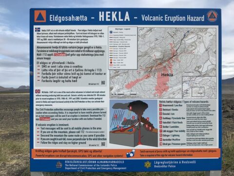
Warning board at Hekla viewpoint
Civil Defense recommends taking all possible precautions when entering and moving around Hekla, and in particular (we are in the 21st century, after all) to turn on your cell phone. The idea is that in the event of an alert about an impending eruption, appropriate text messages will be sent to all phones in the area (you will receive such a message even if you have roaming turned off, so really: be sure to turn your phone on). Information boards around the volcano provide information about the rules of conduct in case of an impending or already starting eruption.

Hekla eruption recommendations
- text messages will be sent to all cell phones in the area;
- if you are on the mountain, be sure to call 112 (if necessary, a helicopter will come for you – you can’t escape the eruption on foot!);
- descend from the mountain by the same route you entered (if possible);
- if volcanic ash falls on you, try to walk perpendicular to the direction of the wind;
- when descending, stick to the crest of the mountain and do not descend into valleys and ravines;
In Iceland, minor earthquakes occur almost every day. So Icelanders are used to them, but that doesn’t mean they ignore them. After all, even the largest eruption (almost) always begins with a small warning tremor. However, although a small earthquake is a common thing in Iceland, if you feel one, stay away from Hekla just in case. And if you have any doubts – call 112.
Raudaskal – a red bowl near Hekla
Rudaskal (Isl. Rauðaskál, literal: Red Bowl) is a small volcanic crater lying about 7 km northeast of the summit of Hekla. It’s not a large crater – the diameter of its caldera is only about 270 meters, and its peak reaches a height of 630 meters. Thus, it is even lower than the Hekla ridge that passes at this height.
Raudaskal is a very nice volcano and an interesting stop on the way to the foot of Hekla. The road departing from the F225 road and leading to the base of the great volcano, runs at the very beginning of Raudaskal’s slope. The ascent to the summit is as possible, but no path leads there. The scree slope is quite steep and loose, so the ascent is surprisingly long, but 30-40 minutes should be enough. You’ll also find tire tracks on the summit without any trouble – if you have the right sturdy off-road car, you can just drive up Raudaskal….
Hekla is located in the southern part of Iceland, about 30 km northeast of the town of Hvolsvöllur. The mighty lone mountain can be seen from afar from many places – the volcano region can be reached by road 26 (from near Fludir, Hrauneyjar, Selfoss or Hvolsvöllur) or by road F225 (Landmannaleið) from near Landmannalaugar.
Probably the best viewpoint of the volcano is at the parking lot on Road 26, at the point where the F225 road diverges from it to the east. This parking lot can be reached on asphalt and also by car without 4×4 drive.
On the other hand, you can drive a car with both axles very close to the volcano itself – the last parking lots are located literally at the foot of the mountain, about 4 km from the very top of the mountain. Along the way you will see beautiful volcanic landscapes and many side craters, including perhaps the prettiest of them – the aforementioned Raudaskal.
If you want to reach the parking lot at the foot of the volcano, take the F225 east from Road 26 and after about 7 km turn south towards Hekla itself. This is also the road leading to the foot of the Rauðaskál volcano.
The ascent to the top of Hekla itself is easiest from the northeast, just from the parking lots at the foot of the volcano, but the top part of the ascent requires glacier equipment, and the entire trip will take practically a full day and is not recommended without a professional local guide.
Much additional information about the volcano can be learned by visiting the multimedia exhibition at Leirubakki (Leirubakki Hotel).
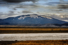
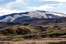
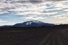
Photos of Hekla volcano


