A
ccording to Icelandic legends, the true creator of the canyon was not a river, but Odin’s steed, Sleipnir, who, descending from the heavens, left a distinctive horseshoe imprint on the ground.

Ásbyrgi is an impressive horseshoe-shaped canyon located about 30 km north of Iceland’s most powerful waterfall, Dettifoss. There are several reasons to see this canyon.
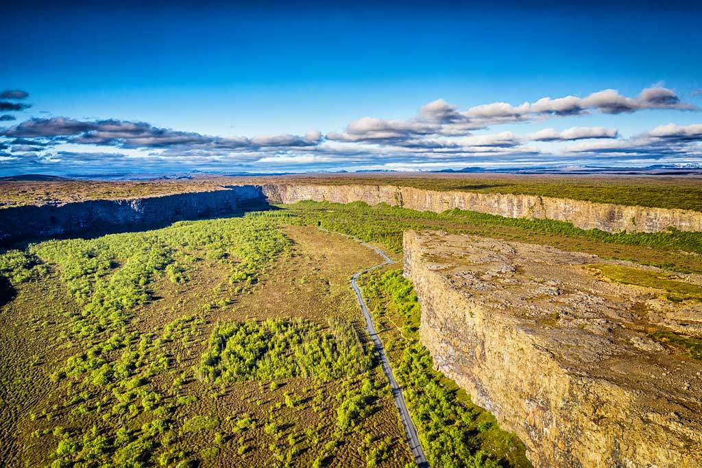
Ásbyrgi is a true natural wonder. It is located in northeastern Iceland, along the route of the so-called Diamond Circle Trail and the North Coast Way (isl. Norðurstrandarleið; English: Arctic Coast Way). It reaches about 3.5 kilometers in length and 1.1 kilometers in width. The canyon area, together with the area around the nearby Dettifoss waterfall formally belongs to Vatnajökull National Park and is called Jökulsárgljúfur (literally, Jokulsa River Canyon). However, it is such an “island” of the park, about 50 km from the northern border of the main park. Interestingly, although the area belongs to the national park, it is managed by the “ordinary” Forest Service.
Asbyrgi is a glacial canyon. It was formed thanks to two gigantic catastrophic floods of the Jökulsá á Fjöllum River. The first was said to have happened about 8,000-10,000 years ago, just after the last ice age, and the next about 3,000 years ago. Later, the river changed its course and flows east of the canyon today.
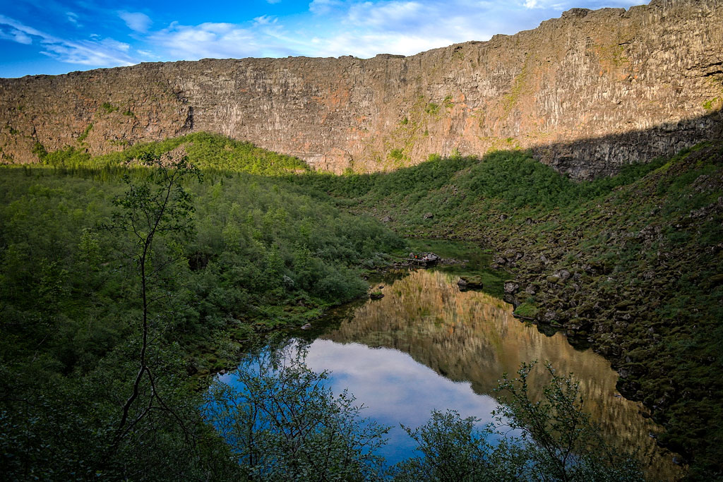
One of the most distinctive features of the canyon is Eyan (literally: island). It is a 25-meter-high rock formation that divides Ásbyrgi in two almost halfway along its length. Also surprising is the unusual for Icelandic conditions environment of dense birch and willow forests. Spruce, larch and pine trees also grow around Ásbyrgi, but these species were artificially introduced here by man in 1947-77.
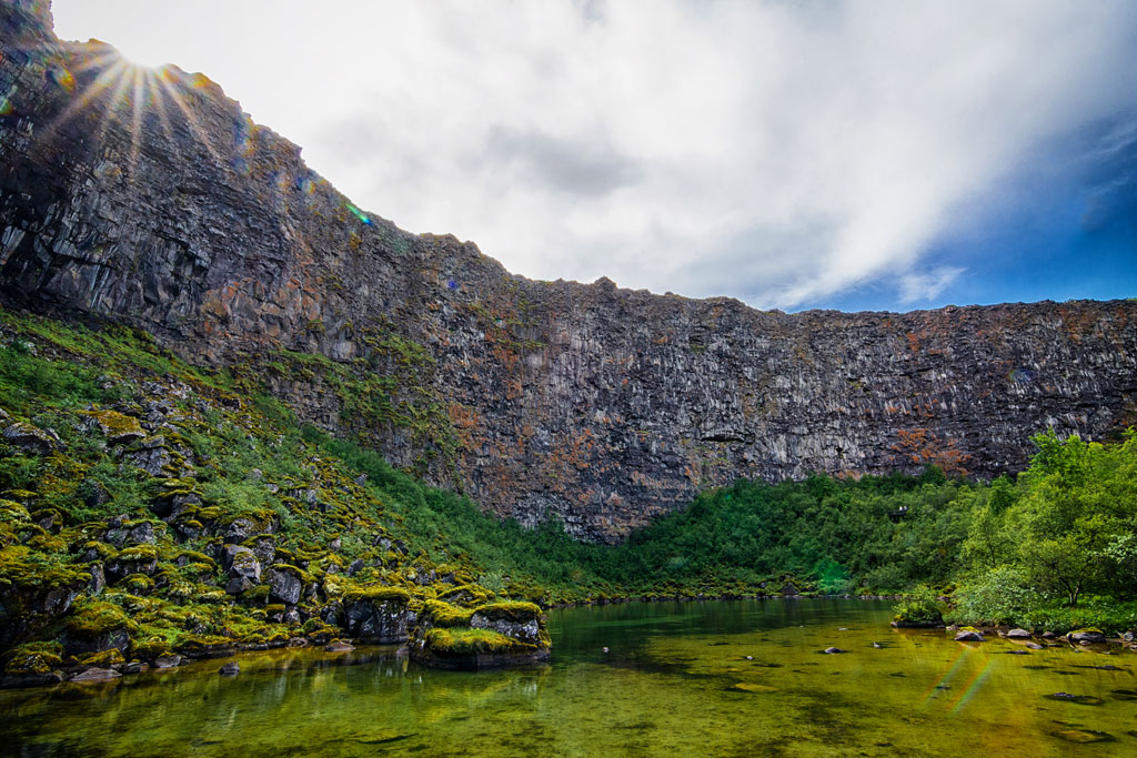
At the southern end of the canyon is the beautiful small lake Botnstjörn. Car parking is a short, pleasant walk away. This is certainly the shortest and easiest hiking trip in Asbyrgi.
On the steep cliffs of the canyon nest Arctic fulmars – unusual birds that use the air currents created over rough waves to fly.
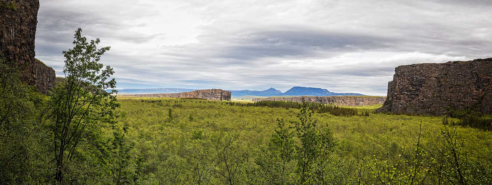
In the eastern part of the park, on the other hand, you can walk through picturesque heathlands and view the smaller but no less attractive canyon of today’s Jokulsa a Fjollum River. Also scattered throughout the park are numerous smaller rock formations created by past floods.
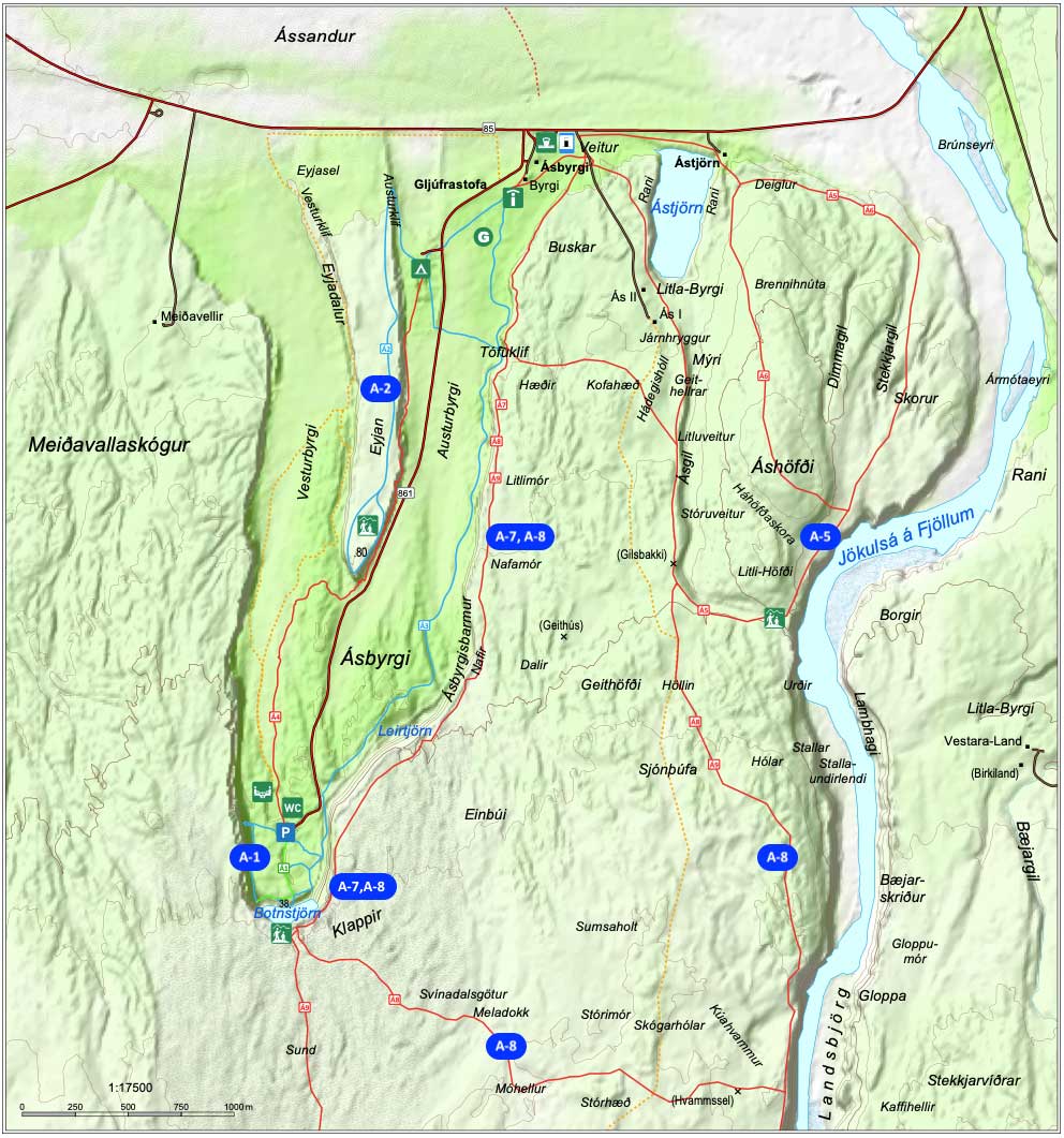
Map: Hiking trails in Ásbyrgi
Length: 1km, 1-1.5 h; easy route;
This shortest route is marked A-1 and leads to Botnstjorn Lake at the southern foothills of the canyon. This route begins at the parking lot in the southern part of the park. We descend the stone steps to the lake itself, after which we can walk to the viewing platform under the western wall of the canyon. From there, along the canyon wall, we can walk to a small hill with a beautiful view of the canyon interior and return to the parking lot.
length: 4.5 km, 2-2.5 h; easy route;
In order to look at the canyon from the height of the central hill – Eyjan (literally, island) – we need to take the A-2 route. This route begins in the north of the park, at the parking lot near the campground. The trail first heads north, towards the place where you can approach the ridge of the hill (head up the wooden stairs). Once on the ridge, the trail turns south and heads toward the edge of the ‘island’ from where there is a beautiful view of the entire canyon.
length: 9 km, 2.5-3h; challenging route
If you want to view Asbyrgi from its crest, you’ll need to take the longer A-7 route. The route starts and ends at the tourist information (Visitor Center) in the northern part of the park. The trail goes east along the golf course and turns south at a trail junction. A shorter but more difficult version of the trail leads immediately south, turns east there and climbs up the canyon slope. On this section we have a railing rope, which will certainly come in handy. Further on, the trail already leads along the canyon rim to the south, up to the viewpoint at the southern end of the canyon. In addition to a great view of the canyon itself, along the way you will also see very interesting rock formations carved there by the river.
In the basic version, you return from here along the same road to the parking lot at the tourist information.
Alternatively, you can return via a circuitous route, switching to the A-8 trail to see the beautiful Jökulsá á Fjöllum River.
length: 12 km, 4-5 h; challenging route
This route is a beautiful half-day hike where you will see all the most beautiful things in the park and Asbyrgi Canyon.
The trail starts and for the first part goes the same way as its simplified, shorter version, the A-7. Only after reaching the Klappir viewpoint at the southern end of the canyon does the A-8 diverge from the A-7 and head east through beautiful heathland to the Jökulsá á Fjöllum River canyon. The path then heads north along the canyon, after which it passes the ruins of the old Gilsbakka house and the Ás park rangers’ cottage and returns to the parking lot. Those wishing to do so can depart further east on the A-5 route along the way.
Of course, routes can be combined with each other and modified. It is worth talking to the park rangers at the information center about all possibilities and the current status of the trails.
length: 32 km, 2 days; challenging route
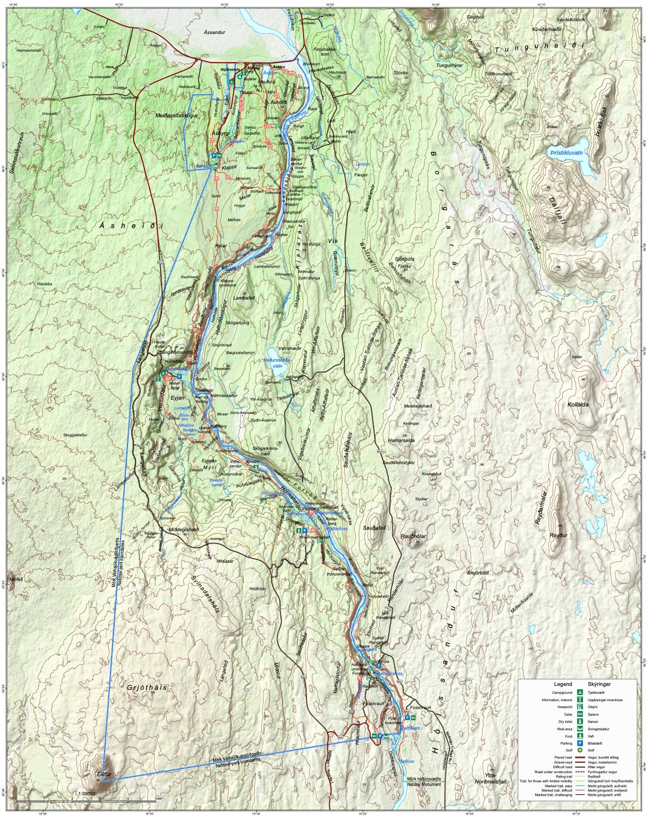
Map: Trails in the Jökulsárgljúfur region
You can download detailed maps of the park with marked hiking trails and other important points from these links:
Asbyrgi Canyon Hiking Trails Plan (PDF 2.7 MB)
Plan of the entire Jökulsárgljúfur area (PDF 7.65 MB)
The canyon has a store, restaurant and tourist information center with a small exhibition dedicated to the canyon; the center is open from 10 am to 4 pm, and from June to August even from 9 am to 6 pm.
Near the entrance to the canyon there is also a campground (open from April 1 to the end of October). There are also places with electrical outlets for campers, toilets, showers and laundry facilities are available to guests, but there is no kitchen for camping guests. Reservations – as always in Iceland – are not accepted, but large groups are asked to confirm their arrival in advance.
Park / Canyon park staff contact:
Ásbyrgi Canyon can only be entered (by car) from its northern side, from Highway 85.
The entrance is located about 90 km northeast of Myvatn and 60 km east of Husavik.
If you must choose one of these roads, choose the western one – 862. Dettifoss itself looks more beautiful from this side (although you won’t get to the very edge of the waterfall), and you can also stop at additional attractions on the way from this side – the Hljodaklettar (Hljóðaklettar) rocks and the red Raudholar (Rauðhólar) mountain. The nearby Selfoss waterfall is also a bit easier to access from the west.