Let’s remember that 1 km3 is as much as a billion (!!!) m3! 18 km3 is 4.3 cu miles and that’s 23.5 billion cubic yards! This helps to understand how the 200 m high cliffs that we can still observe today were formed.
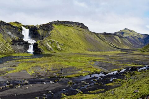
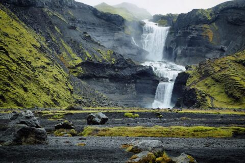
Eldgjá, also known as the Fire Canyon, is a massive eruption fissure of the Katla volcanic system. Its slopes also produced the beautiful Ófaerufoss waterfall.
Eldgjá – the geological wonder of Iceland
Eldgjá is a unique natural phenomenon. Raw, unspoiled, illustrating the immense power of Icelandic nature. Together with the beautiful two-stage Ófærufoss waterfall, the Ófærá River flowing inside, and rocky caves, it creates a picturesque landscape unlike any other place on the island.
Geologically, Eldgja is an eruptive fissure of the Katla volcanic system, whose main crater lies about 80 km to the southwest. Katla is one of Iceland’s more active volcanoes (more than 20 eruptions in 1,100 years), and lies beneath the Mýrdalsjökull glacier, which is up to 700 meters thick. The last Katla eruption to break through the ice was in 1918.
Let’s remember that 1 km3 is as much as a billion (!!!) m3! 18 km3 is 4.3 cu miles and that’s 23.5 billion cubic yards! This helps to understand how the 200 m high cliffs that we can still observe today were formed.
Eldgji’s picturesque surroundings, full of contrasts between green moss islands and black and red soil, provide great hiking conditions. Those interested in longer trekking in the area, and possibly walking to the linear Laki volcano, should secure an overnight stay at the mountain hut Skaelingar hut or at an adjacent campsite.
Ófaerufoss – An impassable waterfall?
Ófaerufoss is a picturesque tiered waterfall on the Ófæra River flowing into the Eldgjá Canyon here.
The waterfall gets its name from the river that forms it – Ofaera (Isl. Ófærá). Its name means in Icelandic something impassable, impossible to cross or pass. And in relation to the river such a name makes perfect sense. However, “impassable waterfall” sounds a bit strange 🙂 Especially since, until 1993, the characteristic feature of the waterfall was precisely the natural rock bridge located in the lower cascade – is it also impassable? However, due to erosion combined with frequent small earthquakes, the bridge collapsed.How to get to Eldgja and Ofaerufoss
Eldgja Canyon is located in the southern part of the Icelandic interior, about 20 km east of Landmannalaugar and 35 km northwest of Kirkjubaejarklaustur (ah those Icelandic names, eh? 🙂 ).
Therefore, Eldgjá is only accessible when the mountain roads are open, especially F208. The southern part of this road, from near the Skaftartunga farm (about 20 km southwest of Kirkjubaejarklaustur), is usually open from mid-June, until mid-September [https://www.road.is/travel-info/condition-and-opening-of-mountain-roads/]. The entrance from the north, from Landmannalaugar and Hrauneyjar usually opens about 2 weeks later.
Naturally, a 4×4 car is needed to reach Eldgja. The road to the canyon is uneven and quite often crossed by rivers. They are not deep, but you need to be careful not to bury your car in the muddy bottom. The exit to the parking lot is about 3 km southeast of the junction of F208 and F235 (leading to the beautifully located Langisjór campground).
A path of about 1.5 km leads from the parking lot to the Ófaerufoss waterfall. You can also follow it farther, more into the Eldgja Canyon, although from the vicinity of the waterfall you can already see it very well. Due to the capriciousness of rivers in Iceland, the trail often disappears, washed away by the waters of Ofaeru. Despite this (in summer) the passage to the waterfall is not a problem.

