GOT (PTTK Mountain Tourist Badge) points are a really cool measure of distance in the mountains. 1 such point counts for walking 1 km on the flat or for climbing 100 m vertically (but only uphill – descents do not count). After adding all the distances and elevations on a given route, we get its total length in GOT points.
Certainly the best known hiking trail in Iceland is the famous Laugavegur. Together with the adjacent Fimmvorduhals and Hellismannaleid trails, it is Iceland’s most popular hiking trail. See what it looks like and what it’s famous for.
In this article, we focus on what the Laugavegur trail itself is like and what you need to know when going on it. On the other hand, in separate articles we write about the following topics, among others:
- How to pack for the Laugavegur (and neighboring) trail: How to prepare for a hiking trip in Iceland
- What all the hostels and campsites along the route look like and offer: Laugavegur campsites and hostels;
- What the neighboring trails look like and what they offer: Fimmvorduhals and Hellismannaleid;
If you prefer a video version, check out this YouTube video:
Video: Everything you need to know about the Laugavegur, Fimmvorduhals and Hellismannaleid trails
What is the Laugavegur trail
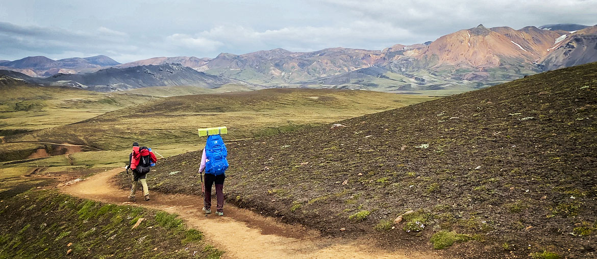
Laugavegur is a hiking trail connecting two beautiful and famous places in the Icelandic interior: Thorsmork (or more precisely: Langidalur campground) and Landmannalaugar. Each of these places is a gem worth visiting, and we have described each of them in separate articles.
Not surprisingly, a trail connecting such great attractions relatively easily and quickly gained enormous popularity. Today it is certainly the most popular multi-day hiking trail in Iceland. At the same time, it’s one of the few trails that can be conveniently reached by bus, and in fact, the only one that can even be hiked, with our luggage from one overnight stay to another going by car, and us walking through the mountains with only a light, small backpack….
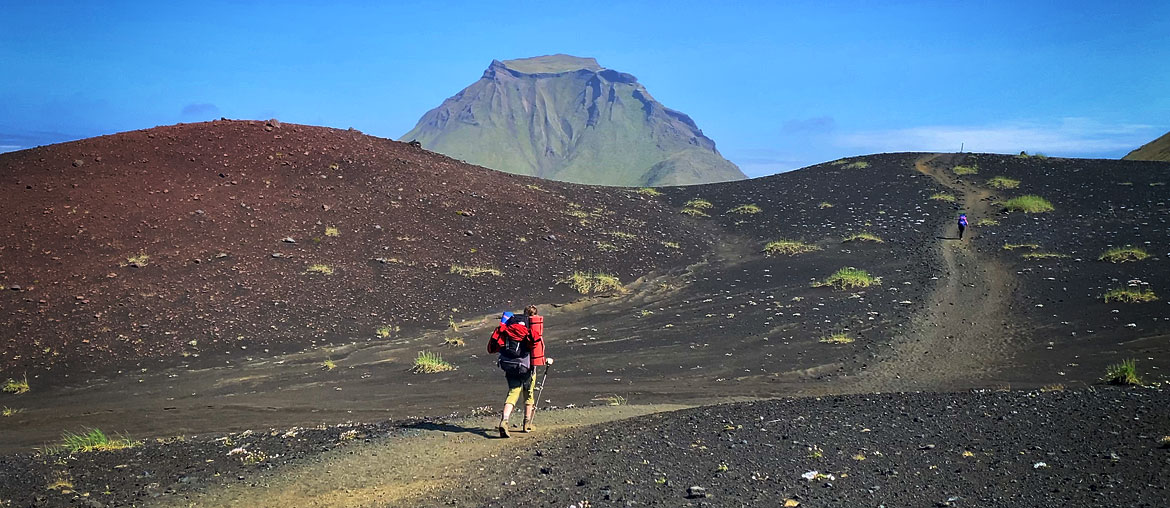
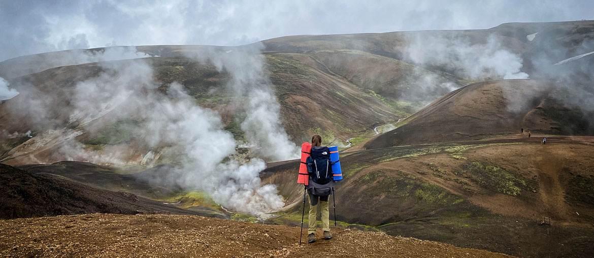
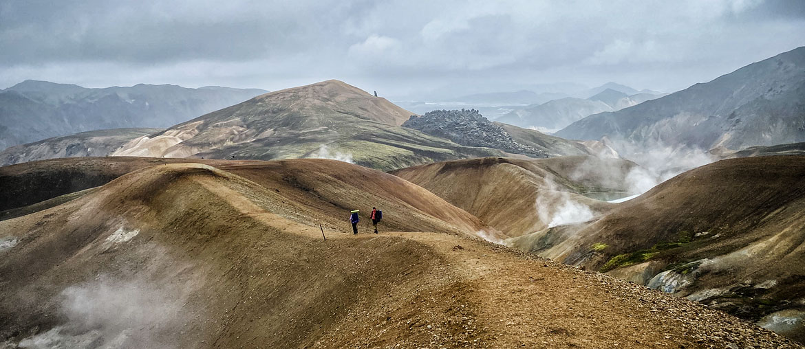
The name of the trail could be translated as “hot springs trail,” but such a name would be somewhat misleading, as the only hot spring we can bathe in along the route is in Landmannalaugar itself. Also, the smaller hot springs and lakes that we can only see lie only near this northern end of the trail, and not along its entire length. While certainly the most interesting and beautiful parts of the trail are precisely the ends of the trail – the colorful rainbow mountains in Landmannalaugar and the dense green slopes of Thorsmork – Laugavegur provides beautiful and unique views along its entire length. Here you will see, among other things, hot springs, plains of volcanic cinders (and ashes), unusual colorful “humpback humps,” perhaps the largest easily accessible obsidian field in Iceland, green groves of dwarf birch, smaller and larger gorges, and icy mountain streams through which the trail leads. Almost every overnight stop along Laugavegur is relatively easy to reach by 4×4 vehicle. Therefore, if you don’t have the stamina, the equipment, the time or simply the desire to hike for several days, but you want to see the most interesting places along the route – there is no big problem with that. You just need to go to Iceland in summer (when the F roads are open) and have a 4×4 car at your disposal (but preferably not a 4×4 urban SUV, but at least the ‘iconic’ Duster). The only exception to the above rule is Hrafntinnusker, located on a high pass, and – to some extent – the hostels and campsites Langidalur and Volcano Huts located in Thorsmork, but on the north bank of the Krossa River (see more in the articles about these campsites and in the general article about Thorsmork).
Course and length of the Laugavegur trail
The Laugavegur trail itself connects the Landmannalaugar and Langidalur campsites (in Thorsmork). In this basic version, the trail is about 53 km long and 65 or 68 GOT (depending on which way you go).
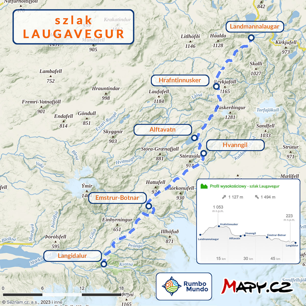
Map of the Laugavegur trail (maps.cz)
GOT (PTTK Mountain Tourist Badge) points are a really cool measure of distance in the mountains. 1 such point counts for walking 1 km on the flat or for climbing 100 m vertically (but only uphill – descents do not count). After adding all the distances and elevations on a given route, we get its total length in GOT points.
The northern end of the trail is not in doubt – it is Landmannalaugar campground. The southern end, on the other hand, is formally Langidalur campsite, but it can be replaced by Volcano Huts or Basar Hut campsite. Both of these campsites are within a 2 km radius of Langidalur and may be better in some situations. Volcano Huts offers more comfort, while Basar Hut is a better base for the Fimmvorduhals trail. All of these campsites are reached by buses from the BSI station in Reykjavik.
If you sleep in a tent, you can walk Laugavegur either way. But if you want to sleep in huts, you have to go south – start in Landmannalaugar and end in Thorsmork. Accommodation in huts on the trail is reserved only in this direction.
The time to walk the entire trail depends, of course, on the one hand on your fitness, on the other on the weather, and on the third on whether you want to walk it as quickly as possible or, on the contrary, slowly and leisurely. Traditionally, the Laugavegur trail is walked from north to south, because then we have almost 400 m less approaches. However, on the scale of the entire route, this is a negligible difference, and some arguments in favor of going from south to north after all (more on this later in the article). Most hikers who are advanced enough to undertake such a multi-day excursion move through the mountains at a speed of approx. 4 GOT per hour. The fastest ones will approach 5 GOT/hour (although that’s rather difficult in Icelandic conditions and on long routes), while those who are calmer or more overwhelmed by the weight of a backpack, or walking in bad weather, will probably walk closer to 3 GOT/hour.
Forcomparison: there is an annual mountain run on the trail, the winners of which complete the entire route in just over 4 hours (the 2023 winner was literally 1 minute short of going below the 4-hour mark). However, those who take more than 9 hours and 15 minutes to run are disqualified. If you are interested in participating in this event take a look at this website: Laugavegshlaup.
The basic plan for crossing Laugavegur is spread out over 4 days and assumes an overnight stay at each campsite along the way (except for Hvanngil or Alftavatn, of which we choose only one). In this plan, the lengths of the daily sections, GOTs and estimated walking time look as follows:
| Daily sections on the Laugavegur trail (4-day version) |
||||
|---|---|---|---|---|
| South direction | North direction | |||
| Landmannalaugar -> Hrafntinnusker |
10 km, 15 GOT, 4-5 h |
Langidalur -> Emstrur-Botnar |
16 km, 22 GOT, 6-7 h |
|
| Hrafntinnusker -> Hvanngil* |
15 km, 17 GOT, 4-6 h |
Emstrur-Botnar -> Alftavatn* |
16 km, 19 GOT, 5-6 h |
|
| Hvanngil -> Emstrur-Botnar |
12 km, 13 GOT, 3-4 h |
Alftavatn -> Hrafntinnusker |
11 km, 17 GOT, 4-6 h |
|
| Emstrur-Botnar -> Langidalur |
16 km, 20 GOT, 5-7 h |
Hrafntinnusker -> Landmannalaugar |
10 km, 10 GOT, 2,5-3 h |
|
| TOTAL | 53 km, 65 GOT | TOTAL | 53 km, 68 GOT | |
20GOT is not a very long stretch if you have a full day to pass it. However, it is important to remember that on Laugavegur we usually walk in a strong, cold wind; that we carry a heavy backpack on our backs; that we have to cross a brisk, cold stream several times; and finally, that we walk every day, and sleep in a tent or a simple shelter. All these factors increase our fatigue, so it’s worth planning routes carefully.
Examples of trails in the Polish mountains, with a length of about 22 GOT include:
- Bieszczady: ascent to Tarnica from Muczne and descent to Wolosaty;
- Beskid Żywiecki: crossing from Zawoja (stop Zawoja Markowa), to Babia Gora and descending to Krowiarki Pass;
- Gorce: loop from the Kowaniec Pętla stop, to the Turbacz mountain shelter and back;
- Karkonosze: ascent from Karpacz (Kopa stop) to Śnieżka via the black trail and return via the red trail;
Although the northern direction has a slightly higher sum of approaches it is much better organizationally. You can read more about the advantages of both directions later in this article.
If the weather is bad (or threatening to break), and crossing almost 30 GOT in one day doesn’t sound problematic to you, you can skip the overnight stay at Hrafntinnusker and walk the entire route in 3 days. It’s a pretty intense 3 days of walking, but quite a few people choose this option. Laugavegur spread over 3 days means the following daily sections:
| Daily sections on the Laugavegur trail (3-day version) |
||||
|---|---|---|---|---|
| South direction | North direction | |||
| Landmannalaugar -> Alftavatn |
21 km, 27 GOT, 7h | Langidalur -> Emstrur-Botnar |
16 km, 22 GOT, 5h30′ | |
| Alftavatn -> Emstrur-Botnar |
16 km, 18 GOT, 4h30′ | Emstrur-Botnar -> Alftavatn |
16 km, 19 GOT, 5h | |
| Emstrur-Botnar -> Langidalur |
16 km, 20 GOT, 5h | Alftavatn -> Landmannalaugar |
21 km, 27 GOT, 7h | |
| TOTAL | 53 km, 65 GOT | TOTAL | 53 km, 68 GOT | |
Another thing is that if you’re going north, you probably won’t walk around Landmannalaugar on that last day, and it will be difficult to catch the evening bus, too. That is, you’ll have to plan one more day on the spot anyway, which means that you basically gain nothing from skipping Hrafntinnusker… On the other hand, if you’re going south and arrive in Landmannalaugar on the morning bus, you can start your route around 11:00 – 11:30 a.m. If you walk fast, you’ll arrive at Alftavatn campground at a pretty reasonable hour. But you will only “run” through the entire beautiful Landmannalaugar, perhaps the most beautiful place in all of Iceland (sic!)…. Is it worth it to plan a trip like this? You will really get a lot more out of the trip if you plan to walk only to Hrafntinnusker on that first day, and spend the ‘saved’ time hiking to Blahnukur or walking through Sudurnamur (or both). Alternatively, leave going out on the trail at all for another day, and spend the entire first day after your arrival on hiking in and around Lanadmannalaugar itself….
Nocleg in Hrafntinnusker you have to skip if you don’t have a reserved place in a hut, and you hit extremely windy weather. The wind on the pass can really rip tents apart.
When planning your trip to Laugavegur, keep in mind that both ends of the route – both Landmannalaugar and perhaps even more so Thorsmork – are so beautiful and interesting that it’s worth spending at least 1 extra day in each. In such a plan, the tour extends to 5-6 days. It is worth planning it this way also because it creates a certain weather buffer. Then you have some minimal flexibility in the implementation of the route and you can adjust at least a little to the weather. It is worth reminding here that in Iceland, as a rule, the so-called wild camping is allowed, i.e. accommodation in a tent outside the campsite (but only in a tent pitched on the ground). Excluded from this rule are national parks and nature reserves. This means that outside the Friðland að Fjallabaki reserve, i.e. south of Alftavatn, we do not have to use campsites and can pitch a tent wherever we want. Campsites, of course, provide some minimum comforts, but there is no obligation to use them.
In the article How to prepare for a hiking trip in Iceland,we write more extensively about what to bring and how to prepare for walking Laugavegur and other hiking trails in Iceland.
Shelters and campgrounds on the Laugavegur trail
There are 6 campsites along the Laugavegur trail, and if you take the southern end of the trail a little more casually, there are up to 8. We describe each of them in detail in separate articles (links next to the names), and below we collect only their most important commonalities and the biggest distinguishing features of each.
Each campground has a hostel and a campground. At each you will also find a small store (basic food, gas for the kettle, snacks, drinks), and in Landmannalaugar even two stores. You’ll find a restaurant at Alftavatn and Volcano Huts and Basar Hut, as well as at Landmannalaugar (although it’s more of a bar and a small one at that).
There are no showers at Hrafntinnusker campground, and no ‘canteen’ tent for campers at Alftavatn. In addition, Alftavatn and Hvanngil lie so close to each other (no more than a 2-hour walk) that, in practice, everyone stays overnight at one of these places and avoids the other.
The hostels along the route are very similar to each other and offer a similar range of services. Accommodation in them needs to be booked quite far in advance, we can use a fully equipped kitchen on site, mattresses are available, but we need to have our own sleeping bag (one with a comfort level of 10ºC is completely sufficient). Most accommodations are single bunks, but there are also double bunks, multiple bunks, and sometimes mattresses are simply spread out on the floor.
No one is allowed into the huts unless they have booked accommodation. Those sleeping in their own tent, for example, cannot use the hut’s kitchen or drying room. There is no way to recharge a phone at the campsites. There are no outlets available to tourists. The exceptions to this are the store in Landmannalaugar (charging for a fee) and the Volcano Huts campsite (free). There is running water for washing up in the huts, but no bathrooms or toilets. Those sleeping in the huts use the same sanitary facilities as those sleeping in the campground. It is a separate room, container or small building.
Unlikemost lowland campsites, there are no kitchens at Laugavegur campsites for people sleeping in a tent to use. Usually (though not always) you can use a ‘canteen’ tent, but all the equipment is tables and benches for sitting.
The price of sleeping in a tent is anywhere from 2,300 ISK (PLN 75) per person, while the price of sleeping in a hostel is 13,000 ISK, or about PLN 415 per person. The shower is an additional 900 ISK (30 PLN) and in this price we have 4 to 5 minutes of hot water. The prices are for the 2024 season, in earlier years it was cheaper, of course. However, each of the campsites is distinguished by something, whether for good or bad. You’ll read the details in separate descriptions of each, but here’s a look at their biggest distinctions in super-short order:
- Landmannalaugar
Hot spring, hot water for washing up, terribly hard ground at the campground, best-stocked store on the entire route (actually, two stores); wonderful views on several trails in the area; - Hrafntinusker
the windiest and coldest of the campsites, because it’s the highest; the only one where there are no showers and the toilets are only “dry” (like our saloons); there are no trash cans at this campsite – we take them with us the next night (even if we sleep in a hut!); a bad-weather shelter under construction (it should be fully operational in 2024); a campground on obsidian deposits – it glitters beautifully in the sun, but quite uncomfortable to sleep in; a curiosity nearby – ice caves (unfortunately, collapsed in 2023); - Alftavatn
small restaurant at the campground (for everyone); no tent or room to prepare a meal or wait out the worst of the weather for those outside the shelter; in windless weather, flies can be a problem, very fond of living – and feeding – on the shores of the lake; no shelter from the wind; the boundary of the Fridland al Fjallbaki reserve runs in the hills north of Alftavatn; - Hvanngil
state-of-the-art (built in 2023) sanitary facilities; several spots in rock hollows protect tent from even the worst wind; former barn (usually) made available to tourists as a canteen; - Emstrur-Botnar
huts with viewing terraces (to the south); campsite on very rough terrain – between several small hills and ravines; as of 2023, it is not allowed to leave garbage here – all tourists take their garbage for the next night; nearby huge attraction: the Markarfljotgljufur canyon; - Langidalur
sizable hostel, but a small campsite, although very nice and green; crossing the Krossa (behind the campsite / south of it) on distinctive bridges; crossing the Krossa only for the largest 4×4 cars; bus stop to Reykjavik (when the water level is high, stop on the south bank of the river); close to the routes to Tindafjoll (a smaller or larger loop) and Valahnukur (one of the key viewpoints of the Krossa valley); - Volcano Huts
the most comfortable, and not at all the most expensive of the campsites (campground: 2,800 ISK (£90), but sauna and any number of showers included; hut site: 9,000 ISK (PLN 290), which is cheaper than at the ‘main’ Laugavegur; chalets: 31,000 ISK (PLN 1,000) for 4 to 5 people); hot spring, sauna, showers at no extra charge or time limit, electricity for unlimited phones, wifi and a real restaurant; also a bus stop to Reykjavik and right next to the scenic peak of Valahnukur; - Basar Hut
campground that is the easiest to get to (among the campgrounds in Thorsmork); sprawling, green, between groves of dwarf birch; a lot of Icelandic families come here; there is a restaurant; best start to the Fimmvorduhals trail and to Hvanargil and Strakagil canyons (both beautiful);
Top attractions near Laugavegur
The entire Laugavegur trail is beautiful and really rich in amazing views. In addition, both ends of it – the beautiful Thorsmork and Landmannalaugar– deserve an absolutely huge mention. However, in addition, it is possible to point out (only?) two places that are particularly worth visiting, but require going off the main trail. These are the Markarfljotgljufur canyon near Emstrur-Botnar campground and the ice caves at Hrafntinnusker.
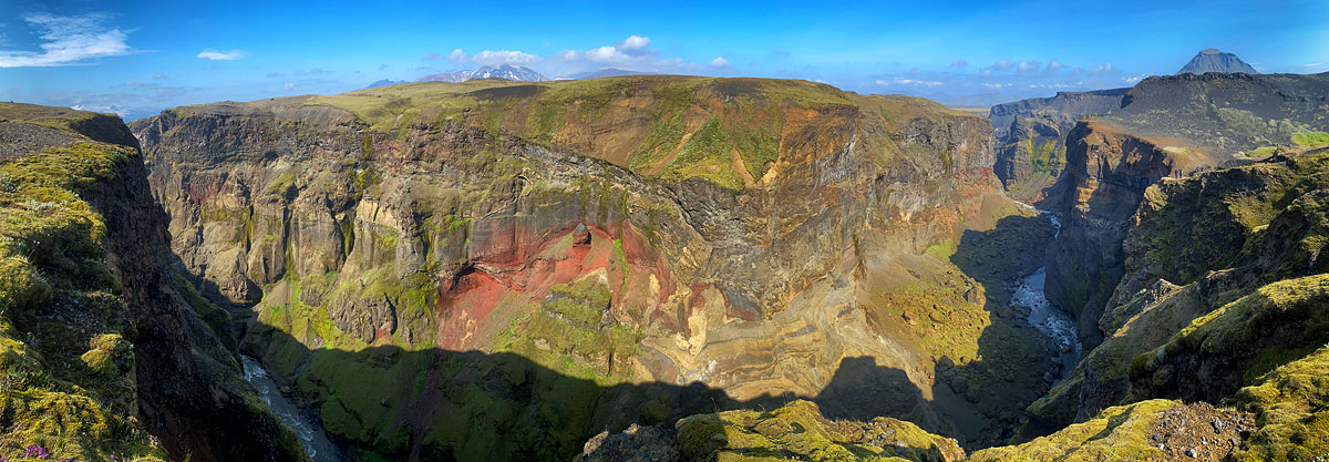
Panorama of Markarfljotsgljufur from the viewpoint[/caption]Markarfljotgljufur is certainly one of Iceland’s largest and most beautiful canyons. It is extremely deep, steep and has beautifully colored walls. Unfortunately, we view it only from above, but it is still very impressive (in good weather). Viewing it requires going off the trail for about 1 hour. During this time you will have time to visit both main viewpoints and feast your eyes on the views [caption id="attachment_11612" align="aligncenter" width="705"].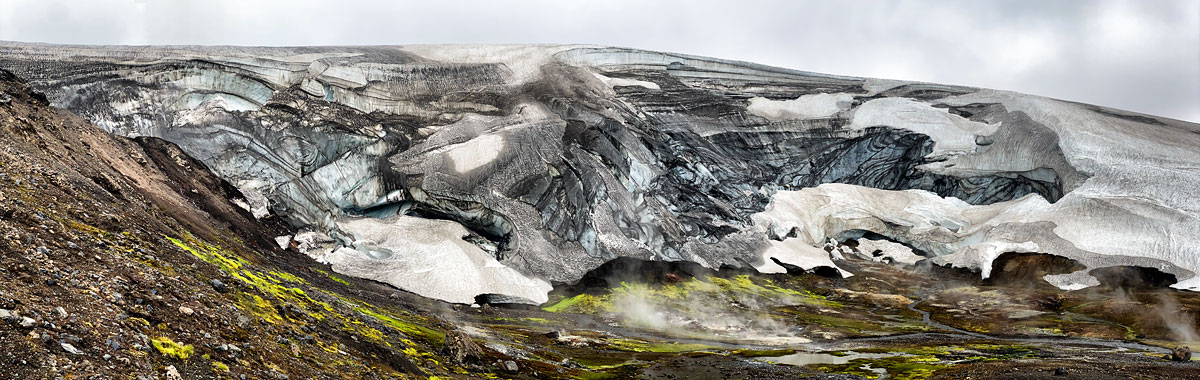 remnants of the Hrafntinnusker cave
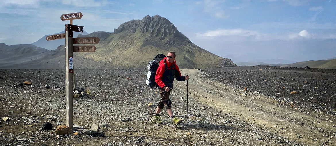
Connecting Laugavegur with other trails
It’s really very worthwhile to combine a trip to Laugavegur with neighboring trails: primarily the Fimmvorduhals to the south, but also the Hellismannaleid to the north/west. We have described both of these trails separately in the linked articles, and below we will only discuss the issues involved in adding them to a trip to Laugavegur.
Laugavegur and Fimmvorduhals
Fimmvorduhals is a trail that runs south of Laugavegur, from Skogar to Basar Hut, and is about 26 km (35 – 37 GOT). It is almost as popular as Laugavegur, and according to many tourists, even nicer and more interesting than its “big brother.” The passage of this trail is best planned for 2 days, although it can also be done in 1 day. We described the trail itself quite comprehensively in the article Fimmvorduhals – the trail of 20 waterfalls (and more…). Therefore, here we will describe only the issues related to the combined passage of both trails.
Both ends of such a combined route can be easily and conveniently reached. But you can return comfortably only from Landmannalaugar – the return from Skogar is surprisingly poorly organized. Therefore, the combined routes of Fimmvorduhals and Laugavegur are definitely better to go from the south (Skogar) to the north (Landmannalaugar). In this direction, the route does have 6 more GOTs, but on the scale of the entire trip, this amount is completely negligible. In addition, in Landmannalaugar there is a store and a hot spring waiting for us, so it’s really a great place to end the trek. Well, and then in Landmannalaugar you can decide whether to add Hellismannaleid to the trip as well …
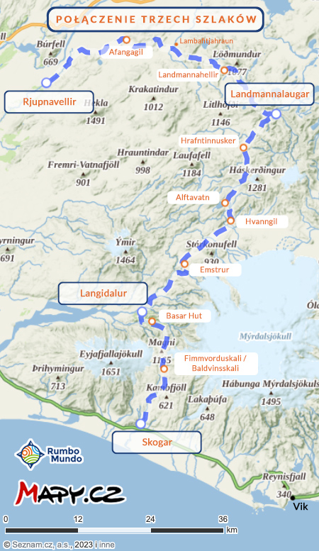
Map: Fimmvorduhals + Laugavegur + Hellismannaleid
Leaving Landmannalaugar is best planned for the day after you get there, so that you have the aforementioned ‘buffer’ for bad weather or injury. And if nothing bad happens along the way, you have an extra day to hike the trails in Landmannalaugar (it’s worth it – see the article about this campground for more details: Landmannalaugar – rainbow mountains like a fairy tale).
So such a full version of the plan requires the dedication of 8 days. On the first day in the morning you leave Reykjavik (and reach Baldvinskala), and on the eighth day in the evening you return to it.
A combination of Laugavegur, Fimmvorduhals and Hellismannaleid
If you are already trekking to Iceland, it would be a shame to pass Fimmvorduhals and Laugavegur and not see the very interesting Hellismannaleid.
The Hellismannaleid is a 3-day trail leading west from Landmannalaugar, so from the northern end of Laugavegur. Its other end is the Rjupnavellir campsite on Road 26, at the foot of the Hekla volcano. To some approximation, the entire trail is just the route to and around Hekla. See its extensive description here: Hellismannaleid – a trail through truly wild Iceland The Hellismannaleid trail is much less popular than the Fimmvorduhals and Laugavegur, though also beautiful and interesting. Its distinguishing features are lava fields and valleys and plains strewn with volcanic ash and cinders. You also pass some really beautiful lakes on the trail. The low popularity of the trail gives you a sense of solitude in the Icelandic mountains – a feeling quite typical of all mountain trails in Iceland, with the exception of Laugavegur and Fimmvorduhals. At the same time, due to its lower popularity, the rules for tourists here are noticeably more lenient and, for example. charging your phone isn’t as much of a problem, and showers (usually) don’t have to be limited to 4 or 5 minutes. This trail in its standard version is another 54 km and 62 to 66 GOT, connects to Laugavegur at Landmannalaugar campground and runs west from there

Elevation profile: Fimmvorduhals, Laugavegur and Hellismannaleid
In addition, it is really worth adding one day between each of the trails. Such extra days are your reserve for a small injury or bad weather, but also a chance to see the most interesting “side” trails in Thorsmork and Landmannalaugar.
So all in all, the shortest trip is an express 3 days on Laugavegur alone, but the longest is up to 11 days (or more 🙂 ) on the Fimmvorduhals + Laugavegur + Hellismannaleid combo.
Which way is better to go Laugavegur
Is it better to cross Laugavegur from north to south or from south to north? A surprisingly popular topic of online conversations about planning the passage of Laugavegur is the question of whether it is better to go from north to south or vice versa – from south to north. Is it better to start in Thorsmork and end up in Landmannalaugar, or to just start in Landmannalaugar and go to Thormsork. The topic is – in our opinion – generally overstated and not that important, but we present below the arguments in favor of actually going from north to south and those in favor of the opposite direction.
Why it’s worth walking Laugavegur from north to south
The basic or classic arguments for walking Laugavegur from north to south are:
- Laugavegur in the version from north (Landmannalaugar) to south (Thorsmork) has almost 400 m less ascent (according to map.cz, it is exactly 1127 m of ascent, which is exactly 368 m less , than the route in the northern direction);
- Shelters can only be booked in order from north to south;
- Most hikers just go from north to south. Walking in the same direction, you will meet on the route only those who are walking clearly faster or clearly slower than you. On the other hand, you will only pass those who are walking in the opposite direction;
- After passing the volcanic-cinder-sand section of the northern part of the trail, the entrance at the end to the green Thorsmork, full of trees and bushes, is incredibly impressive. It feels like we have reached an oasis in the desert.
People who want to sleep in shelters or go in such an organized group basically have no choice – they have to go from north to south. And in principle there is nothing wrong with that. But for those who want to sleep in a tent or combine sleeping in a tent and in hostels, the strength of these arguments is rather average, especially when juxtaposed with the opposite.
It seems that the opinion that Laugavegur needs to be crossed from north to south is being strongly conquered by companies organizing tours with overnight stays in hostels. They want to convince customers that their offer is the only reasonable solution.
Why you should cross Laugavegur from south to north
Here are the reasons why it is better to walk Laugavegur (and neighboring trails) from south to north (and possibly west):
- The differences in approach are negligible
On Laugavegur alone, it’s less than 400 meters, or less than 10% of the total in terms of GOT points. For the combined Fimmvorduhals and Laugavegur, the difference depending on walking direction is also less than 10% of the total. And if you combine all 3 trails described here, the difference in total approaches drops to 1.2%, or basically disappears. - Rather, one should be afraid of descents than approaches
The two steepest parts of Laugavegur you go up if you are going north and descend them if you are going south. On the surface, this may sound like an argument for heading south, but these descents are then so steep as to be potentially dangerous. Especially in bad weather, it is certainly safer to climb these steep slopes than to descend them. That is, it is safer to go north. - Best to sleep in a tent
Of course, sleeping in hostels has its advantages – mainly that it is dry and warm. However, these accommodations are really expensive, have to be booked early and offer (almost) no opportunity to change the route. In practice, they are also crowded and bustling, it’s hard to get a room without a snorer, and there is often a queue for the kitchen…. As a variety, a moment to dry clothes or in case of bad weather, it is worth considering 1 or 2 nights, especially in the highest huts (Hrafntinnusker, Fimmvorduskali, Baldvinskali). However, an entire route (or three) with overnight stays in hostels is definitely not a good idea for those seeking peace, quiet or solitude in the mountains. - Going north you have better views
Of course, you can always turn around – and it’s often worth it – and you have beautiful views not only in front of you and behind you, but of course also on the sides. However, when you go north you have the sun constantly behind your back – it doesn’t blind you and nicely illuminates the landscapes in front of you; and when you go south, unfortunately, it shines constantly in your eyes, and the landscapes viewed under the sun lose their appeal; in addition, on Fimmvorduhals going north you see each successive waterfall fairly far away and you walk quite a long way up to it; while going south you will see it only when you reach it (and turn around); and on the same Fimmvorduhals going north you can see the beautiful Krossy Valley and Thorsmork in front of you (almost) all day long; meanwhile, going south you have to keep turning around – de facto you won’t and you will lose a lot of views; - Landmannalaugar is a better end of the route
Of course, Landmannalaugar is a remarkable place both at the beginning, end and middle of any route. However, the hot spring, the not badly stocked store, the well-maintained showers – all of these things become more meaningful when you end the tour, not when you start it. And also the ‘rainbow mountains’ themselves are a rarity, which are great as a tour destination, and probably less so as a tour start. It’s better to walk toward such a major attraction than away from it. - The return from Skogar is quite a hassle.
The access is good to any nodal point of the trail, but the return from Skogar is clearly more troublesome. So it’s better not to end the trip in Skogar, because the campground there is “so-so” at best, and getting out of there to Reykjavik is a bit more difficult than from other nodal points on these trails. Therefore, if you want to cross (also) Fimmvorduhals, it’s definitely better to do it from south to north, and this also determines the direction of walking on the other trails; - Hellismannaleid is best left for last
The virtues of the Hellismannaleid trail become more valuable against the backdrop of Laugavegur and Fimmvorduhals. If you have plans to walk the Hellismannaleid, it is certainly better to start in Skogar (or Thorsmork) and finish in Rjupnavellir, not the other way around;
So all in all, we strongly recommend crossing all three trails and starting in Skogar and finishing in Rjupnavellir.
Hazards on the Laugavegur trail
Laugavegur is a well-defined and popular trail. There are no very serious dangers on it, and in case of need, help can get here relatively quickly (but never underestimate these mountains!) The main difficulties we have to reckon with on the trail are:
- strong wind
strong wind is naturally a feature of all of Iceland, but in the highlands, however, it is stronger, and sometimes even hurricane force; the Hrafntinnusker campsite is particularly prone to strong winds – it is here that the famous “nights of flying tents” happen, and if it blows really hard, the staff “drives” tourists to campsites lower down; the wind can cause real danger to your tent (although this is rare), constantly causes you to get colder faster on the trail (a hat and warm gloves are a year-round necessity), plus in many places it lifts volcanic ash from the ground, which some tourists ignore, but others protect their mouths and eyes with scarves because of it; - steep slopes
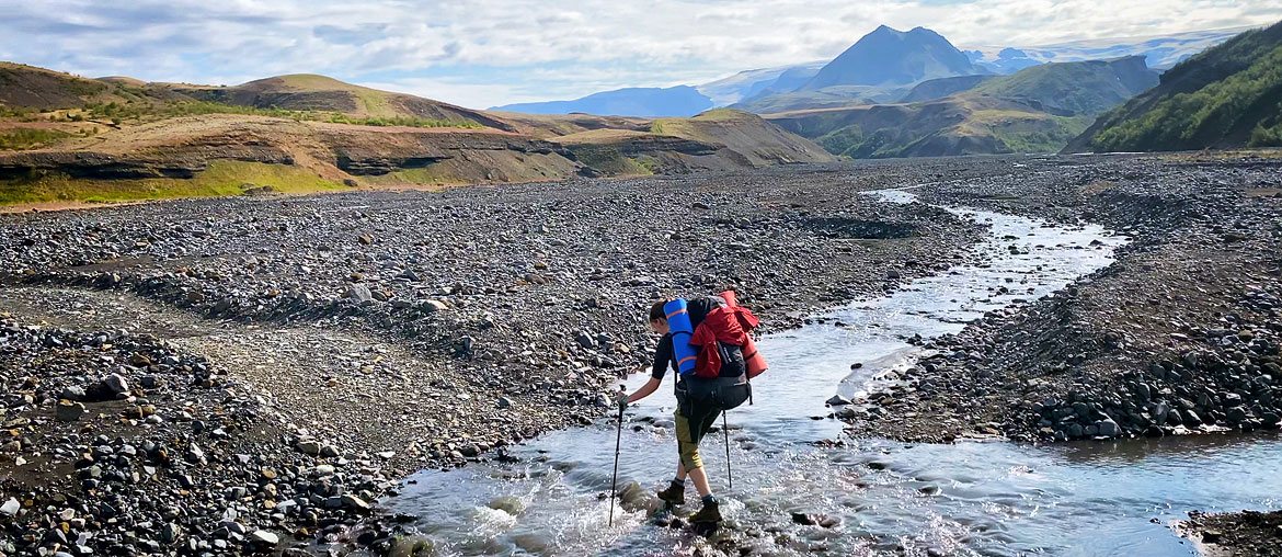
north of Alftavatn and south of Emstrur lie two large and really steep slopes; going north you will ascend them, going south – descend; on the ascent (so going north) they are a hindrance, but not a danger; while on the descent (going south) you have to be really very careful on them (be sure to bring poles!) – a fall here can end very badly; - crossing streams
only the stream south of the Hvanngil campsite is sometimes really deep – after major rainfall you need to go approx. 100 m north / northeast, to a shallower ford (if you are walking from the north – ask at the hut about the condition of the ford, if you are walking from the south – ask people walking from the north); the water in the other fords very rarely reaches above the knees, but even such fairly shallow water usually flows very fast and is really icy; in addition, the bottom of the streams is uneven and often rocky – it’s really worth taking water shoes and trekking poles with you – both are great for crossing the streams smoothly and without problems;
Getting to the Laugavegur trail
You can get to both Thorsmork and Landmannalaugar by bus from Reykjavik before noon and set off on the trail right away, or – better – spend half a day hiking in the area and set off on the long trail the next morning. The buses are quite accommodating for tourists. That is, they leave Reykjavik as early as 6:30 in the morning and return even at 10 pm in the evening. In addition, as much as possible, you can book rides back from a different place than the one you arrived at. So as much as possible, for example, you can go to Skogar, and return from Landmannalaugar or Rjupnavellir. Or vice versa.
Pertinent exceptions are buses returning to Reykjavik from Skogar (the southern end of the Fimmvorduhals route). The return from here is a bit more complicated, as the morning bus has a very long layover and only reaches Reykjavik in the evening, while the afternoon bus does not guarantee seats, and still leaves quite early (16:25 on weekdays and 15:07 on Saturdays and Sundays). More in the article Fimmvorduhals – a trail of 20 waterfalls (and more…).
Cost of a trip to Laugavegur
If you want to go to Iceland just to pass Laugavegur, it will be quite expensive long weekend. But if the trail crossing is just a supplement to a larger trip to Iceland, it won’t add too much to the cost of the trip, and it will make it immensely more attractive. The biggest potential costs of such a trip are equipment (if you don’t have it and have to buy or rent it specifically for this trip) and accommodation in hostels, if you choose to do so. You will consume some gas for your stove (small cartridge: about 1000 ISK (£30), large cartridge about 1800 ISK (£55). Some candy bars, sweets, sunscreen, etc. etc. Not including these costs (and the price of the flight), the approximate costs of the trip are as follows:
| Costs of going to Laugavegur | |||
|---|---|---|---|
| Laugavegur | Laugavegur +Fimmvorduhals |
Laugavegur +Fimmvorduhals +Hellismannaleid |
|
| planned number of days | 5 | 7 | 10 |
| Access/return by bus (price for 2024, per 1 adult, return ticket) |
800 zł | 700 zł | 700 zł |
| Accommodation in hostels (price for 2024, per 1 adult) |
1660 zł | 2490 zł | 3365 zł |
| accommodation in a tent (price for 2024, per 1 adult) |
300 zł | 450 zł | 655 zł |
| daily hot shower (where possible) |
180 zł | 240 zł | 300 zł |
| freeze-dried food | 350 zł | 490 pln | 700 zł |
| travel insurance | 45 zł | 60 zł | 85 zł |
| TOTAL: shelters TOTAL: tent |
3035 zł 1675 zł |
3980 zł 1940 zł |
5150 zł 2440 zł |
The service is not cheap, as it costs 10,000 ISK (about 320 PLN) for each piece of luggage and each day. But you can imagine a group that nevertheless carries most of the ‘usual’ stuff on their backs, but, for example, a bag with food, a large tent and self-inflating mattresses is carried in just such a ‘cab’. It may sound strange, but it is quite popular. For those interested, here is the link: Luggage Transport for Laugavegur.
Photos from the Laugavegur trail