Iceland owes its beautiful landscapes to unusual volcanic (and glacial) activity. But why exactly here are there so many active volcanoes? And why exactly here – in the middle of the Atlantic Ocean – was this island formed? How fast is it growing, and where can we observe it? Finally: what do Iceland, Greenland and Bermuda have in common? You will read about all this below.
Did
you know that the collapsed caldera of one of Iceland’s volcanoes is as large as 8 x 11 km / 5 x 7 miles? And did you know from which volcano the lava flowed into the ocean as much as 200 km / 125 miles away? In the next article in this series, we describe in more detail the formation, operation and various interesting facts about selected Icelandic volcanoes (see:
How Icelandic Volcanoes Work).
V
olcanic activity effects are not only lava and volcanic mountains. Volcanoes can heat water far above 100 ºC / 212 ºF, create dragon glass and in one flood pour out more water than a regular lake holds. We write about the fascinating, stunning, but also frightening effects of Iceland’s volcanoes in the third article in this series:
Stunning Effects of Iceland’s Volcanism
But let us begin with why Iceland came into existence in the first place.
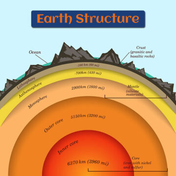
Earth’s inner structure
The oceanic crust is usually about 5-10 km / 3-6 miles thick, while the continental crust, under large mountain ranges, can be as thick as 80 km / 50 miles. They also differ in age. Oceanic crust is much younger – the oldest is about 200 million years old – while continental crust can be over 3 billion years old!
The tectonic plates themselves can not only be of different ages, but also of different sizes. Some are huge like the Pacific one (103 million km2), while others are much smaller like the coconut plate. The coconut plate lies southwest of Mexico and is a small tectonic plate – it is only about 3 million km2 But “small” is, of course, a relative term – for comparison: the area of Nevada – or Italy – is about 300,000 km2, so 10 times less. The plates also differ in what percentage of their surface is solid, dry land (vs seabed)
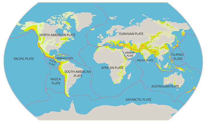
Major tectonic plates

Schematic of plate tectonics
The research was later continued by, among others, teams preparing to lay telecommunications cables across the Atlantic. But it wasn’t until 1953 that Marie Tharp and Bruce Heezen, thanks to a very detailed study of the Atlantic Ocean floor, discovered that in the middle of the Mid-Atlantic Ridge runs a so-called rift valley. To put it in some perspective: a valley runs through the middle of the mountain range, along the entire length of the range and in parallel to it…
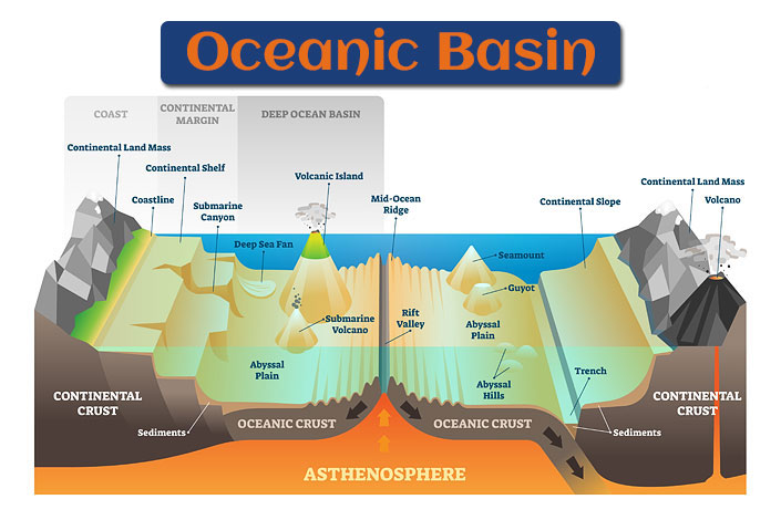
How a rift valley emerges
T
hanks to tectonic plate spreading in the rift region, the eastern and western parts of Iceland are moving away from each other by about 2 cm / 0.8 in per year.
The Mid-Atlantic Ridge runs down the middle of the Atlantic almost from pole to pole, but only protrudes above the water’s surface at a few points. One of them is Iceland and the best place to see the rift valley elevated above the water’s surface here is certainly Thingvellir National Park
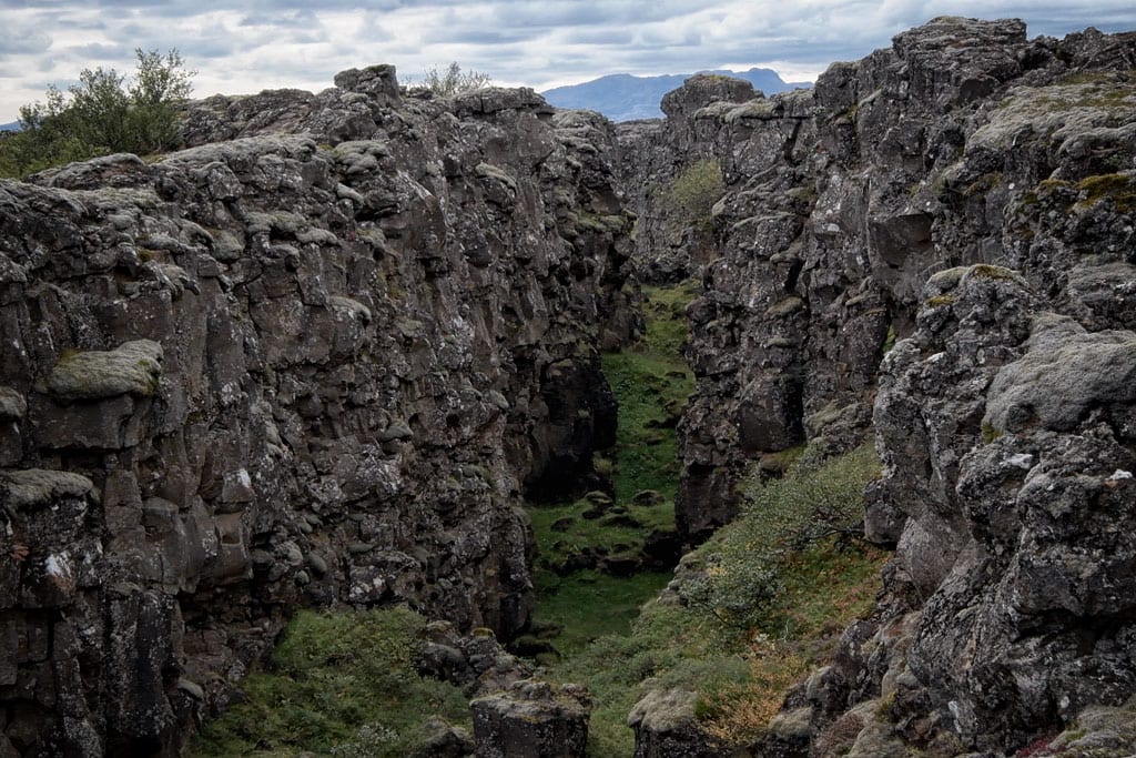
A fragment of an ocean rift in Thingvellir Park
But since the Mid-Atlantic Ridge along its entire length (about 16,000 km / 10,000 miles!) is on average submerged 2,500 meters under water, and it protrudes above the surface only in a few places, why does it protrude at all? And why exactly in these specific places? In other words: why does Iceland exist at all?
Convection and tectonic plates’ movements alone do not explain the island’s formation.
Island’s hotspot
In light of Tharp and Heezen’s discoveries, the origins of Iceland have begun to be reconsidered. Its geological structure consists of distinctive belts that symmetrically converge toward the center (in the map below: blue, green, orange), from the oldest in the west and east to the youngest sediments in the central part of the island.
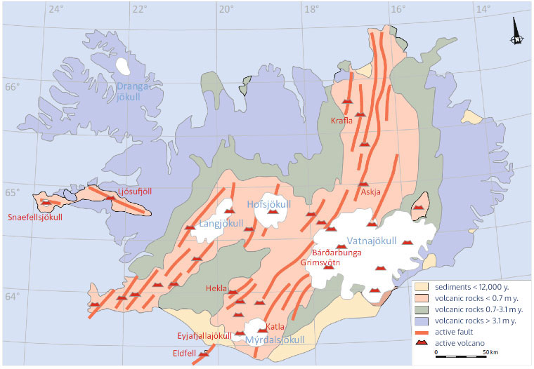
Geologic map of Iceland (Fraedrich, 2018)
A hotspot is an area where the heat flux reaching the Earth’s crust from the mantle reaches much higher than average. And the location of the spot is not related to the movement of the continents, but to processes in the deep layers of the Earth’s mantle. Therefore, the hotspot is stationary or may move differently than the continents “floating on top”. It is, so to speak, a fountain of heat gushing from the depths of the mantle, toward the Earth’s crust. Therefore, in turn, looking from the perspective of the continent, the hotspot can change its position. On a human scale, of course, these are extremely slow processes, but if the continent is moving westward, then from its perspective the hotspot is moving eastward underneath it….
Increased volcanic activity is also recorded in the area of such a heat spot.
T
he hotspot on which Iceland is located is the largest we know of in the entire Atlantic!
With the above findings, we now have all the information to reconstruct the mechanism of Iceland’s creation.
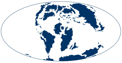
Earth continents about 60 million years ago
In the illustrations below we can trace the course of events that led to the configuration we see today. The apparent eastward migration of the spot is due to the westward shift of the Atlantic rift. Greenland itself, lying on the North American tectonic plate, is moving westward away from the rift line as new crust forms on the Atlantic rift. But the entire rift is also moving westward relative to the Earth’s core, due to the uneven growth of the different tectonic plates. That’s why the hotspot that used to be underneath Greenland is now at the height of the Atlantic rift, significantly contributing to the formation of Iceland.

History of the Icelandic hotspot
As a place with such good conditions for the formation of new oceanic crust, we can very well call Iceland a new, tiny protocontinent. Who knows how big it will be in another 60 million years (and where will we find it…).
The other side of the coin – Bermuda
An interesting, somewhat inverse, result of the same volcanic processes and tectonic movements in the Mid-Atlantic Ridge area is the formation of Bermudas.
Bermuda – the northeastern tip of the so-called Bermuda Triangle – is an archipelago of more than 100 islands about 1,000 kilometers east of the US coast (not to be confused with the Bahamas, located almost next to Florida).
Today’s islands are the remnants of the caldera top of a large volcano that formed and was once active on exactly the same tectonic fracture where the Mid-Atlantic Ridge lies today[10].
Thanks to the growth of the North American plate, by today Bermuda has “wandered” about 2,000 kilometers west of the Mid-Atlantic Ridge, and is more than 3,300 kilometers away from the Azores.
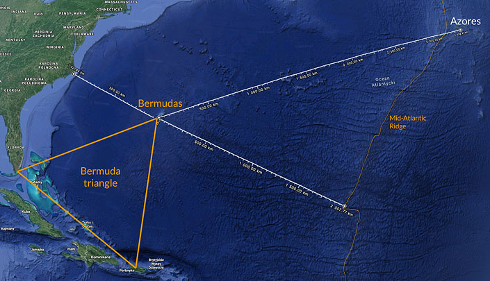
The Bermuda archipelago
Volcanoes and the effects of their activity
Iceland’s peculiar genesis and location make it home to a great number of volcanoes, the vast majority of which remain active. Volcanoes are a powerful but also very diverse phenomenon. In Iceland, their largest eruptions took place several thousand years ago, but the most recent lava field is only a few years old (it formed in 2021-21), and the last major eruption took place in 2010. Did you know that one of the volcanoes in Iceland has a caldera measuring 8×11 km / 5×7 miles and as deep as 700 m / 0.4 of a mile?! And do you know how a volcanic mountain can form without erupting lava?
 Lots of interesting facts and practical information about how volcanoes in Iceland form and work, a brief description of a selection of the most interesting volcanoes and the largest and most fateful volcanic explosions can be found in the following articles: How Iceland’s volcanoes work and Iceland’s biggest volcanic eruptions. You are guaranteed to see at least some of the volcanoes described there and the effects of their eruptions on your trip to Iceland! These articles will give you a better understanding of what you are dealing with.
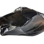 We write about the traces of volcanic activity and the various effects and impacts of Icelandic volcanoes in the third article of this guide series: Stunning effects of Iceland’s volcanism. You’ll probably be surprised to read there how common an earthquake is in Iceland. Or to how hot can water get when a volcano is having its way with it (that’s far more than 100 ºC / 212 ºF!). You’ll also learn how geysers work, what are fumaroles, what the “dragon glass” from The Game of Thrones is, and the effect of a sudden outpouring from a glacier of as much water as would fit in a few regular lakes….
Bibliography
- Czechowski, L. 1994. Plate tectonics and convection in the Earth’s mantle. PWN Scientific Publishers, Warsaw
- Fraedrich, W. 2018. Iceland from the West to the South. Springer International Publishing (27-92)
- Fridriksson, T. 2006. CO2 emissions and heat flow through soil, fumaroles, and steam heated mud pools at the Reykjanes geothermal area, SW Iceland. Elsevier
- Jaroszewki, W., Marks, L., Radomski, A. 1985. Dictionary of Dynamic Geology. Geological Publishers, Warsaw.
- Książkiewicz, M. 1979 Dynamic geology. Wydawnictwa Geologiczne, Warsaw
- Lamur, A et al. 2018. Disclosing the temperature of columnar jointing in lavas. Nature
- Pożaryski, W. 1977. Island in the light of plate tectonics. Geological Review
- Stanley, S. M. 2002. Earth History. Publishing House of Science PWN, Warsaw
- Thordarson, T., Larsen, D. 2006. Volcanism in Iceland in historical time: Volcano types, eruption styles and eruptive history. Elsevier
- Earth Observatory – NASA.gov
- Mid-Atlantic Ridge – UNESCO.org


