Amore complete description of how to incorporate the ascent of Hekla and Raudaskal into the Hellismannaleid passage can be found at the end of the article.
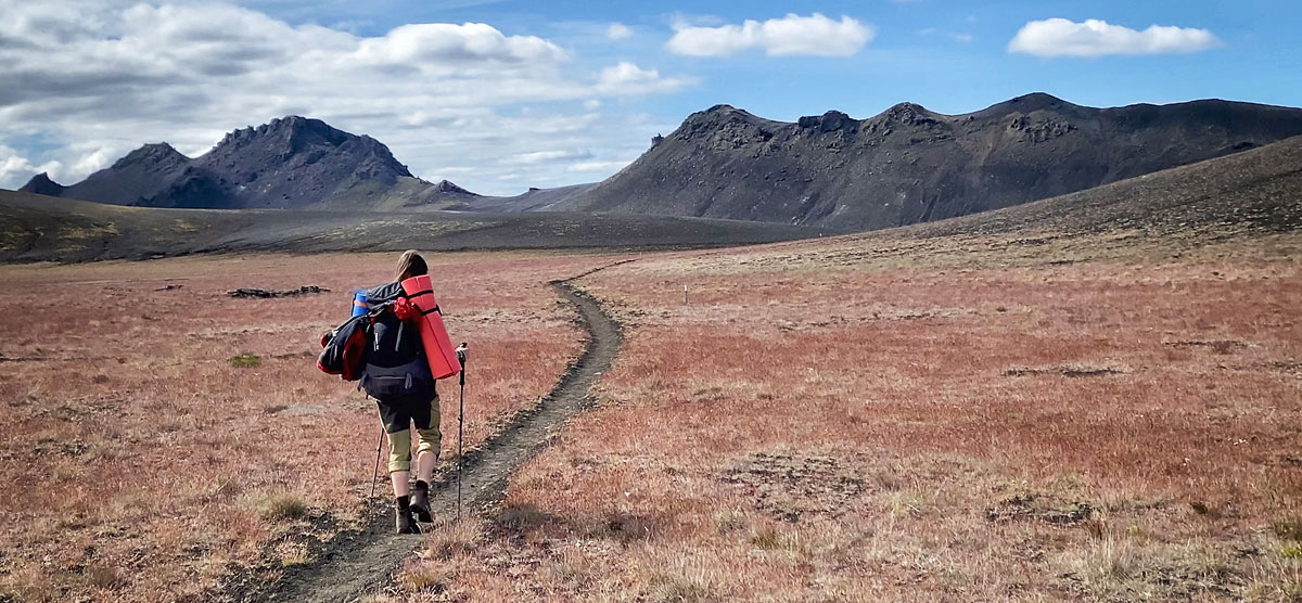
Hellismannaleid (isl. Hellismannaleið) is a less popular but very interesting three-day hiking trail west of the famous Landmannalaugar. If you want to see vast volcanic cinder fields, beautiful mountain lakes, solidified lava fields and enjoy hiking in relative solitude, this trail is exactly for you.
The name Hellismannaleid can be translated as “the way of the cavemen,” but it’s obviously not about American cartoons from the ’60s, but about the shepherds who may have spent the night in caves in the area.
Where the Hellismannaleid trail lies
Hellismannaleid connects the Rjupnavellir campsites on Road 26 and the famous Landmannalaugar. It runs generally in the same direction as the F225 road with a similar-sounding name – Landmannaleið
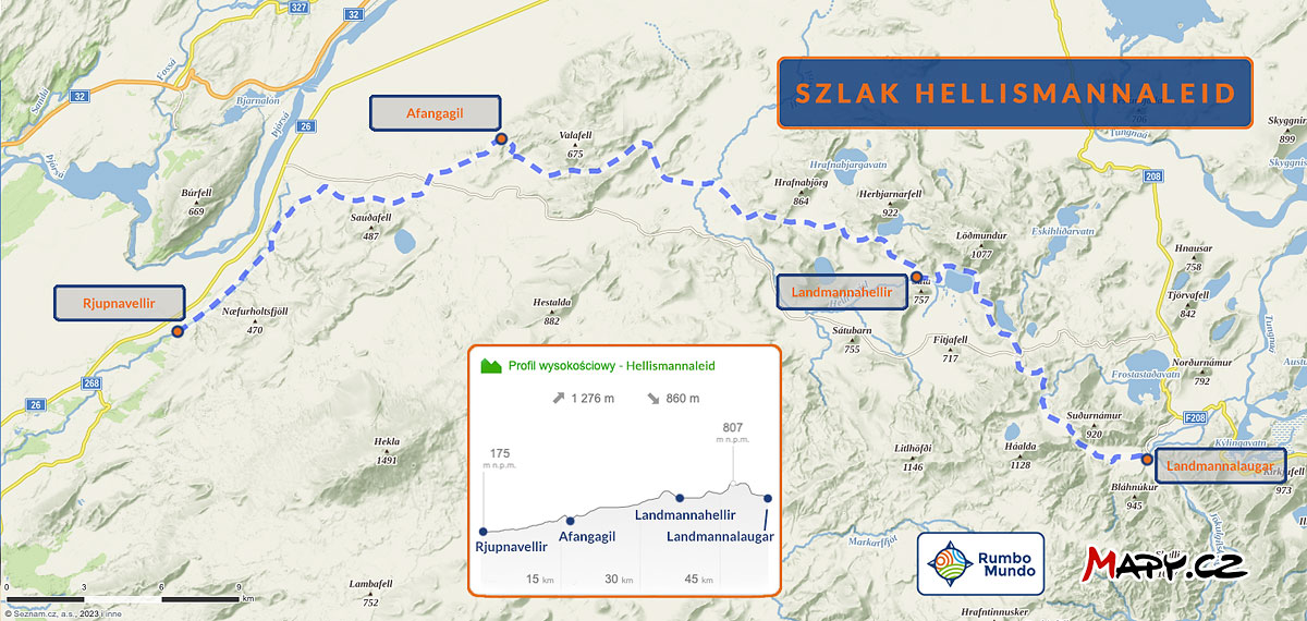
Hellismannaleid: trail route and elevation profile

elevation profile of the Hellismannaleid trail [maps.cz]
Attractions: why you should walk the Hellismannaleid trail
The Hellismannaleid landscape offers a different beauty than the famous Laugavegur. Its beauty is modest, sometimes even minimalist, but it certainly cannot be denied that beauty. In addition, it is on this trail that we will perhaps see more of the real Iceland – empty, quiet (albeit windy) and cinder-volcanic. And still, as often as on Laugavegur we stop with the thought “but what an amazing place!”

views on the Hellismannaleid trail
Where the trail approaches the F225 road a bit, you can sometimes see a car passing in the distance, but this is also a rare sight, because usually the road from the trail is not visible. On this trail we don’t get the feeling of running in a tourist turnstile, but rather we can experience that nice mountain solitude that many people go to the mountains for in the first place… Certainly the most distinguishing feature of the landscape on this route are the volcanic fields of lava, cinders and ashes. While it may not sound spectacular from the description, walking through a volcanic cauldron filled with even black cinders is truly quite a sight and experience (again: especially for those who have previously walked Laugavegur and Fimmvorduhals). Also, even an hour’s walk on a flat as a table plain lined with such cinders and absolutely devoid of any landmarks is a very interesting experience (a map and GPS on your phone really come in handy!). On the side of views – in addition to the volcanic deserts – beautiful and beautifully located mountain lakes are also characteristic here. Each of them is a wonderful place for a short stop. Most are also stocked, so we can meet anglers at some of them
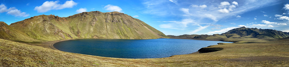
One of the lakes at Hellismannaleid – Lifrarfjallavatn
Of the individual, separate places of interest requiring a descent from the trail, we should mention here the colorful Rauðaskál crater, located about 5 km southeast of Sauðafellsvatn Lake. The crater is quite colorful (rust-red) and can be approached very closely by 4×4 vehicle. However, from a hiker’s perspective, it’s quite a departure from the trail, as it’s about 12 km (15 GOT) one way

Hekla as seen from the trail
A fairly clear (usually) path leads to the summit via side ridges, where there are no very steep sections. However, in addition to generally good mountain preparation, crampons and poles will certainly come in handy for such an outing.
Amore complete description of how to incorporate the ascent of Hekla and Raudaskal into the Hellismannaleid passage can be found at the end of the article.
How to get to the Hellismannaleid trail
Both ends of the Hellismannaleid trail can be reached by your own car. You don’t even need a 4×4 to get to Rjupnavellir – the campground lies just off paved road 26.
Rjupnavellir is a great base, for people who do not have a 4×4 car, but want to see Landmannalaugar. This is described in detail in the section “how to get there by bus” in the article Landmannalaugar – rainbow mountains like a fairy tale.
Both ends of Hellismannaleid also lie on the route of buses going from Reykjavik, via Selfoss and Hella, to Landmannalaugar (Hella is a bit out of the way, but it’s a popular stop and transfer point there). Therefore, it is quite convenient to take the trail directly from Reykjavik. Buses start the route under Laugardalur campground (Dalur hostel) and stop in the city center (Trex line) or at BSI station (RE line).
Scheduled departures from Reykjavik are set for 6:30 a.m., 7:45 a.m. and 12:45 p.m. Buses arrive at Rjupnavellir about 2.5-3 hours later, and at Landmannalaugar itself after a total of 4-5 hours. You can set off from Landmannalaugar at 14:30, 15:45 and 18:00, and from Rjupnavellir (on the same buses) at 16:00, 17:00 and 19:30, respectively. These are, of course, scheduled times and in reality are often subject to minor adjustments.
If you want to take a bus in Rjupnavellir – be sure to indicate this when purchasing your ticket, and preferably additionally remind the ride organizers by phone the day before the ride. Unfortunately, drivers sometimes forget to enter this stop….
Rjupnavellir is a good base for Hellismannaleid and Landmannalaugar, for those who drive around Iceland by car without 4-wheel drive. Here you can spend the night, leave the car and follow the trail to Landmannalaugar, and after 3-4 days return by bus. And if you are not interested in the Hellismannaleid trail itself then here you can take a bus and go for a day or two to the beautiful rainbow mountains themselves (see more: Landmannalaugar – rainbow mountains like a fairy tale).
Campsites and accommodations on the Hellismannaleid trail
In addition to the beginning and end – Rjupnavellir and Landmannalaugar – there are two more campsites along the Hellismannaleid trail: they are Afangagil and Landmannahellir. All four offer a similar level and range of services, although not identical, of course. You’ll find details in the linked articles about each of these places, but here we’ll just mention their most important features. At each campsite you can – without prior reservation – pitch your own tent. In 2023 it cost 2000 ISK per person per night (about 65 PLN), for 2024 we expect a price of about 2300 ISK, or about 75 PLN. It is also possible to book a place in a hut on each, but it costs much more – from 7,000 ISK to 11,000 ISK, or about 225 PLN to as much as approx. 350 PLN (in 2024 probably up to 13,000 ISK, or about 415 PLN). The hostels do not offer bedding – you must bring your own sleeping bag. Showering is an additional fee (2023: 400 – 500 ISK, or about PLN 15; 2024: up to 900 ISK, or PLN 30), but in Afangagil and Landmannahellir it is not time-limited. The owners ask not to waste water, but de facto we use it any way we want. Anyway, this often means that we actually use less of it. In Rjupnavellir and Landmannalaugar you will find tourist stores with basic items – tourist food, snacks, gas for bottles. The stores in Landmannalaugar are two and much larger, so there you can also buy all sorts of camping accessories, maps or alcohol. Prices – naturally – are quite high.
- Rjupnavellir stands out for the possibility of free recharging of electrical devices and an open wifi network;
- Afangagil stands out negatively – the lack of any tent or room where campers could, for example, prepare and eat a meal while being sheltered from the wind and rain;
- Landmannahellir offers perhaps the nicest views and is also popular with fishermen and those interested in horseback riding;
- Landmannalaugar is positively distinguished by, among other things, a hot spring, and negatively by the fact that the campsite here is terribly hard and it is difficult to drive a pin or herring into the ground;
Once again: you can find detailed information about these campsites in the linked articles.
How to plan the passage of the Hellismannaleid trail
On the route of the Hellismannaleid trail, between its extreme points, lie two campgrounds. It is natural, therefore, to spread the route over 3 days. This certainly has a number of advantages, but if you prefer to walk more, the weather is favorable, and one night without a shower doesn’t seem terrible to you, you can walk the Hellismannaleid faster – in 2 days – and in two ways.
Standard Hellismannaleid trail plan: 3 days
Since we have two campsites along the way, the Hellismannaleid route is standardly spread over 3 days, regardless of the direction of march. You start and end in Rjupnavellir or Landmannalaugar, and spend two intermediate nights in Afangagil and Landmannahellir. With this plan, there are a comfortable twenty-odd GOTs for each day, so only about 6h of walking.
Hellismannaleid: dividing the trail into 3 days
| Daily sections on the Hellismannaleid trail (3-day version) |
||||
|---|---|---|---|---|
| East direction | West direction | |||
| Rjupnavellir -> Afangagil |
17 km, 20 GOT | Landmannalaugar -> Landmannahellir |
16 km, 21 GOT | |
| Afangagil -> Landmannahellir |
21 km, 27 GOT | Landmannahellir -> Afangagil |
21 km, 24 GOT | |
| Landmannahellir -> Landmannalaugar |
16 km, 21 GOT | Afangagil -> Rjupnavellir |
17 km, 19 GOT | |
But on the other hand, short day sections mean that you end the day early and have a lot of free time, which you are a little unsure what to do with. Meanwhile, shortening the route by one day allows you to shorten the entire trip and save, if only on the cost of accommodation or the food you take with you. If walking longer day sections is not a problem for you, consider one of the following alternative plans for crossing the Hellismannaleid in 2 days.
Hellismannaleid in 2 days: sleeping at campsites
The first way to cross Hellismannaleid in two days is to bypass one of the “intermediate” campsites. Better to bypass is Afangagil, because it offers no ‘canteen’, bypassing it saves a bit of walking (by bypassing it you go more straight ahead), and there are nicer views at Landmannahellir.

possible shortcuts to Hellismannaleid

Variant of the route via Raudaskal (and Hekla)
On the other hand, between these mountains and the place where the Hellismannaleid intersects with the F225 road (that is, the place near which it is worth returning to the trail), you will find quite a few roads and paths.
If time and weather are favorable, you can also approach the shore of the beautiful Sauðafellsvatn Lake for a stop (e.g. lunch?), or you can combine this option with the next one and north of Raudaskal bounce northeast toward the bivouac at Lambafitjarhraun…. If you allow yourself to go off the trail, the possibilities are indeed plentiful. Passing through Raudaskal adds about 15 GOTs (12 km) to the day’s plan. Thus, the total will be approx. 35 GOT’s, but you are partially walking ‘on azimuth’, so potentially a bit slower than the trail. There are also some of the best views of Hekla itself from Raudaskal, and climbing to the top of Hekla is about 27 additional GOT’s, so in total you have a route of 50 GOT’s to do that day (Raudaskal will be on the way, ‘in a package’ so to speak). If the weather is beautiful and you can count on views from the summit and, of course, you like to walk fast and for a long time, this is as good an idea as possible. Just remember that in the peak areas of Hekla you are almost guaranteed snow, ice and head-breaking wind. Don’t underestimate this mountain and prepare very well if you want to climb it (or hire a guide).
Hellismannaleid in 2 days: sleeping in the wild
Alternatively – and probably best if you sleep in your own tent – you can walk the Hellismannaleid in 2 days by sleeping in the “middle” night in the wild.

Hellismannaleid – 2-day variant
Sladies outside a campsite in a tent pitched on the ground is as allowed in Iceland as possible, as long as you don’t do it in a national park, nature reserve or on private land (unless with the owner’s permission; see: Umhverfisstofnun | Where can you camp).
In practice, if you want to hike the Hellismannaleid in two days, you need to find a place to spend the night west of the summit of Hrafnabjorg and Lake Saudleysuvatn, because that’s where (roughly) the western boundary of the Fridland ad Fjallabaki Nature Reserve runs, where sleeping wild is precisely prohibited.
Conveniently, then, is the old lava field of Lambafitjarhraun, which lies just beyond the reserve’s western boundary. Between the rocks, mosses and volcanic sand you’re sure to find a convenient spot for a tent, and a small stream flowing here provides water for drinking, cooking and micro-washing. So the conditions for camping are really quite good.
In addition, from here in both directions – both to Rjupnavellir and to Landmannalaugar, and regardless of which way you go – you have about 30-35 GOT to go. That is, in principle, anyone should be able to do such a route in about 10 hours. With a stop for lunch and correction for fatigue or bad weather – a maximum of up to 12 hours. That is, it is a long day, but acceptable. And if you walk fast, you will even get away with maybe 8h.
Ne often the Hellismannaleid trail is chosen as a complement to the famous Laugavegur, which in turn can also be combined with the passage of the beautiful Fimmvorduhals. About how to organize a trip to these combined trails, how to prepare for it, equip yourself for it, when to go and what you can expect along the way, we write in the article Laugavegur – Iceland’s most beautiful trail.
Safety on the Hellismannaleid trail
There are really no dangerous places on the Hellismannaleid trail

Where does the trail go next?
(Answer: to the mound in the middle of the ridge)
Unfortunately, the path “disappears” precisely in those places where it passes through flat areas, and therefore devoid of good landmarks. In addition, printed maps are available only at a scale of 1:100,000, so they do not allow accurate navigation in such more difficult areas.
Therefore, the absolute best solution is an app like Mapy.cz or AllTrails and a map of the area downloaded to the phone. The phone does a great job of showing the trail and location even when it is in airplane mode, which saves its battery (and as a rule there is no GSM coverage on the trail anyway). Walking on Hellismannaleid myself, I didn’t take the paper map out of my backpack even once…
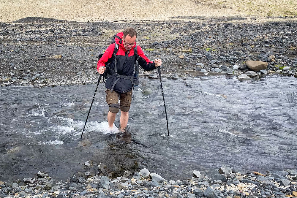
stream on the Hellismannaleid
How to pack for Hellismannaleid
Hellismannaleid does not require any special preparation or equipment, beyond what you should take with you on any Icelandic, or any mountain, trail in general. You absolutely need to prepare for cold weather and strong winds (for more on the weather in the Icelandic highlands, see here: Weather in different regions of Iceland), but not much more. We have more extensively and thoroughly described the equipment you should take on trips in Iceland in a SEPARATE ARTICLE, and we invite you to read it in this regard.
Photos from Hellismannaleid